Hadseløya
| Hadseløya | |
|---|---|
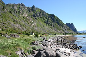
| The west of Hadseløya | |
| Waters | European Arctic Ocean |
| Archipelago | Vesterålen |
| Geographical location | 68 ° 32 ' N , 14 ° 47' E |
| length | 15 km |
| width | 6.5 km |
| surface | 102 km² |
| Highest elevation | Lamlitinden 656 moh. |
| Residents | 5369 53 inhabitants / km² |
| main place | Stokmarknes |
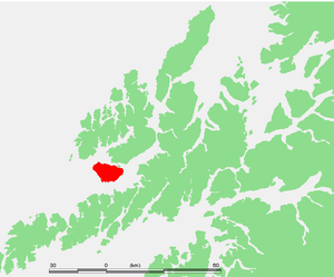
Hadseløya is an island in the Vesterålen region in the Norwegian municipality of Hadsel in Fylke (administrative district) Nordland . With its location in the Hadselfjorden, it is the link to the islands of the Lofoten region in the south and the islands of Vesterålens in the north.
General
The E 10 runs on the east side of the island and connects the two main towns of Stokmarknes in the north and Melbu in the south. A branch line runs west around the island, so that the other places are also connected. Together they are exactly 42 km in length, the reason for the nationally famous Hadsel Marathon .
The interior of Hadseløya consists of a mountain range up to 656 m high, which offers a fantastic panoramic view of the two archipelagos that is easy to hike.
Stokmarknes is also home to Norway's largest regional airport with over 100,000 passengers a year.
Famous pepole
- Richard With , founder of Hurtigruten
- Madrugada , rock band
- Dag Jostein Fjærvoll , politician
Web links
- Pictures from Hadseløya ( Memento from March 11, 2007 in the Internet Archive )
- View of Stokmarknes
- Stokmarknes harbor
- Melbu harbor


