Moskenesøy
| Moskenesøy | |
|---|---|
| Main town Reine on the Vestfjord | |
| Waters | European Arctic Ocean |
| Archipelago | Lofoten |
| Geographical location | 67 ° 59 ′ N , 13 ° 0 ′ E |
| length | 35 km |
| width | 5 km |
| surface | 186 km² |
| Highest elevation | Hermandalstinden 1029 moh. |
| Residents | 1263 6.8 inhabitants / km² |
| main place | Pure |
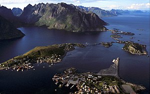
| Reine, Hamnøy and Sakrisøy from the air | |
Moskenesøy is an island in the southern part of Lofoten in Norway . The main town is Reine , other places on Moskenesøy include Moskenes , Å , Sørvågen , Sund, Sakrisøy and Hamnøy .
Between Moskenesøy and the neighboring island of Værøy to the south there are special tidal currents, called Moskenstraumen , which are considered to be the model for the mythical "maelstrom".
Since 2018, the west coast of Moskenesøy and the offshore islands have been part of the national parks in Norway as Lofotodden National Park .
Economy and Transport
Fishing is still the most important economic factor today. But tourism and salmon farming are also gaining in importance.
The European route 10 connects the island of Moskenesøy with the other northern islands of Lofoten and since 2007 without ferries to the mainland. There are ferry connections with the mainland at Bodø and with the southern island communities in Lofoten, Værøy and Røst .
There are good bus connections to Leknes , Svolvær and Stamsund . In Leknes there is an airport with a connection to Bodø, in Svolvær and Stamsund the ships of the Hurtigruten stop .
Attractions
- Telecommunications Museum in Sørvågen
- The townscape in Reine
- Museum village Å
- Stockfish museum in Å
- Doll and toy museum in Sakrisøy.
- Kollhellaren , cave with cave paintings on the west side of the island


