
Trondheim
| coat of arms | map | ||
|---|---|---|---|

|
|
||
| Basic data | |||
| Commune number : | 5001 | ||
| Province (county) : | Trøndelag | ||
| Administrative headquarters: | Trondheim | ||
| Coordinates : | 63 ° 26 ' N , 10 ° 24' E | ||
| Height : | 3 moh. | ||
| Surface: | 528.6 km² | ||
| Residents: | 205,163 (Feb 27, 2020) | ||
| Population density : | 388 inhabitants per km² | ||
| Language form : | neutral | ||
| Postal code : | 7010-7052 | ||
| Website: | |||
| traffic | |||
| Railway connection: |
Trondheim – Storlien Dovrebanen Nordlandsbanen |
||
| politics | |||
| Mayor : | Rita Ottervik ( Ap ) (2003) | ||
| Location in the province of Trøndelag | |||

|
|||


Trondheim [ ˈtrɔnhajm ] or [ ˈtrɔnjæm ] (previously written Trondhjem , German outdated Drontheim ) is located at the mouth of the Nidelva River in the province ( Fylke ) Trøndelag in Norway and was founded in 997 as Nidaros . With 205,163 inhabitants (as of February 27, 2020), Trondheim is the third largest municipality in the country after Oslo and Bergen . With a total area of 529 square kilometers, it has included the surrounding settlements in addition to the urban area since 1964.
Trondheim is the seat of the provincial government for Trøndelag and the diocese of Nidaros , which is also home to the praeses of the Church of Norway . A large number of the 30,000 students living in Trondheim are enrolled at the Technical University of Trondheim NTNU. The University Hospital St. Olavs Hospital employs around 10,000 people and has a number of national specialist functions.
Trondheim is the center of retail and public administration for all of central Norway. Many businesses in the city rely on technology that has been developed in collaboration with the research communities at the Technical University.
With the Værnes airport , with rail connections from Vy to Oslo, Bodø and Sweden and with the Hurtigruten quay, Trondheim is an important transport hub for the entire northern part of Norway.
The city has a rich cultural offer and is home to the Trøndelag Symphony Orchestra, the Trøndelag Theater and the regional jazz scene Dokkhuset. A number of museums and galleries convey visual arts and history. The Trondheim-based football club Rosenborg Ballklub has qualified for the UEFA Champions League several times.
Surname
The medieval name of the city Niðaróss is composed of the river name Nið and Old West Norse óss "mouth" and means "mouth of the Nið". In the late Middle Ages, the name Kaupangen i Trondheimen "trading center in Trondheim" spread, which in the officially used Danish language was shortened to Trondhjem and danized. In addition, the name Nidernes was also in use after the coin inscriptions.
Since Norway gained full independence in 1905, nationalist circles across the country have sought to replace Danish names with the medieval Norwegian forms (as happened in the case of Oslo ). At the instigation of the cultural association Norges Ungdomslag ("Norwegian Youth Group"), the Norwegian Parliament finally passed a law according to which the city was renamed Nidaros on January 1, 1930 . This renaming, which was carried out without involving those directly affected, led to a storm of protest among the population and the city government in Trondheim. There was also a press war between the newly founded newspaper Nidaros under Håkon Løken and the traditional address avisen .
Parliament was forced to modify its original decision and eventually approved a compromise proposal by Trondheim businessman Ivar Lykke . Instead of the Dano-Norwegian name Trondhjem , Lykke pleaded for the nine-Norwegianized form Trondheim (with the diphthong -ei- typical of Nynorsk ). The defeat of Nidaros led to an advertising boycott that lasted until the German occupation in 1940. The name Trondheim has officially been in use since March 6, 1930, but the older Trondhjem is still in use today.

View in north-westerly direction to Trondheim and the island of Munkholmen in the Trondheimfjord

Houses on the Nidelva with Nidaros Cathedral (far left) and Bakke Bru (far right)


geography
location

Trondheim is at the mouth of the Nidelv River at 63 degrees 25 'north latitude and 10 degrees 24' east longitude. The city center lies on a peninsula bordered by the Trondheimsfjord to the north and the Nidelven river to the east and south. The inner city area lies on a plain open to the north, which is delimited to the east and west by mountain areas with peaks 250 to 550 meters high. In the south the level rises to the higher Heimdalsplateau.
In 1964 the municipalities of Strinda, Byneset, Tiller and Leinstrand, which over the years have become part of the urban area, were annexed to the city of Trondheim. The area of today's municipality of Trondheim covers 342.4 square kilometers. In the outskirts of the municipality there are large areas that are used for agriculture, around 17% of the total area. About 33% of the total area of the municipality is forest.
The population is 205,163 (as of February 27, 2020) and was 150,166 on January 1, 2001 (still not including Klæbu, which was incorporated in 2020 ). The population development can be explained by the good job market situation in the city and the desire of the population for a diverse range of services and culture. In addition to the registered population, there are around 15,000 students who are registered in other municipalities. In total, about 30,000 students study in Trondheim, so that about every sixth inhabitant of the city is a student.
| Trondheim | ||||||||||||||||||||||||||||||||||||||||||||||||
|---|---|---|---|---|---|---|---|---|---|---|---|---|---|---|---|---|---|---|---|---|---|---|---|---|---|---|---|---|---|---|---|---|---|---|---|---|---|---|---|---|---|---|---|---|---|---|---|---|
| Climate diagram | ||||||||||||||||||||||||||||||||||||||||||||||||
| ||||||||||||||||||||||||||||||||||||||||||||||||
|
Average monthly temperatures and rainfall for Trondheim
Source: WMO
|
|||||||||||||||||||||||||||||||||||||||||||||||||||||||||||||||||||||||||||||||||||||||||||||||||||||||||
climate
The climate in Trondheim is mild and humid compared to the rest of central Norway. The city is under the influence of the polar climatic zone in the north and the temperate climatic zone in the south. From the west, the city is influenced by the western wind belt of the northern hemisphere. In this way, the weather in Trondheim is not very stable.
The annual mean temperature is 5.3 degrees, in January at −3.1 and from June to August at 13.7 degrees. The lowest value of the temperature was measured in 1899 with -26.1 and the highest value in 1901 with 35.0 degrees. Average annual rainfall is 892 mm (1961–1990) and the city has an average of 200 days of rainfall. There is snow in Trondheim for around 70 to 100 days.
City structure
On January 1, 2005, a new city structure was introduced. Trondheim is divided into four districts. In detail:
- The Midtbyen area includes the city center, Tyholt, Byåsen, Trolla and Ila.
- The Østbye district includes Möllenberg, Nieder Elvehavn, Lade , Strindheim, Jakobsli, Vikåsen and Ranheim.
- The Lerkendal district includes Lerkendal, Nardo, Flatåsen and Moholt .
- The Heimdal district includes Heimdal, Byneset, Tiller , Kolstad, Saupstad and Kattem.
history
middle Ages
From around the year 950 there are traces of a trading post on the peninsula between the fjord and the mouth of the river Nidelv. In 997, Trondheim was founded as a city by King Olav I Tryggvason . Due to the favorable, easily defendable location and the natural harbor ( UN / LOCODE NO TRD) at the river mouth, the city was able to develop into a flourishing trading center for the Trondelag region. Trondheim was the seat of the king in the Middle Ages and thus the capital of Norway .

In the Middle Ages, Trondheim was also the country's religious center and an important pilgrimage site for Northern Europe. The basis for the pilgrimages was the Olavs tradition. Olav II. Haraldsson had tried to unite the country as a Christian king, but was defeated and fatally wounded in the battle of Stiklestad (in today's Verdal) in 1030 . In the following year he was canonized and pilgrimages to his shrine began. His followers had transferred his remains to Trondheim. They were first kept in the Clement Church, built by Olav Trygvasson, and shortly afterwards transferred to the Christ Church, the later Nidaros Cathedral . Adam von Bremen wrote that the pilgrimage to Nidaros Cathedral began in the Oslofjord . From there one either went by ship to Trondheim or took the more arduous land route.
In 1050 Trondheim became a bishopric under the Archdiocese of Bremen . The church now had significant income from the church tithing and owning land. In order to sell these goods, trade connections from Trondheim to Northern Europe were expanded. This led to a constant growth of the city.

In 1152 Pope Anastasius IV sent Cardinal Bishop Nikolaus Breakspear to Norway as plenipotentiary. There he established a Norwegian church province with an archbishop in Nidaros. Norway was divided into four dioceses; in addition there were the dioceses on the Faroe Islands and Greenland .
Øystein was the second Archbishop of the Norwegian Church Province. He had lived in exile for a while in England, where he had become acquainted with English church architecture. Back in Trondheim, he began building a Gothic cathedral, which was largely completed in the course of the 13th century. He also built a fortified courtyard next to the church (in Norwegian : Erkebispegården ). A plague epidemic in 1349 caused a large part of the population to die. As a result, the economy in the city and the surrounding area also stagnated.
In the late Middle Ages , the distribution of power between the Church and royal power changed. With the Reformation , the crown took control of the property and thus the income of the church. Norway and with it Trondheim lost their independence and became part of the Danish-Norwegian Empire . Trondheim became the seat of the governor of the Danish crown. His residence was in the archbishop's former court.
17th and 18th centuries
The city of Trondheim experienced an economic and cultural heyday in the 17th and 18th centuries. The basis of the growth was the timber and fish trade with the northern European countries. The export of copper from the mine and the smelter in the mountain town of Røros also contributed to economic growth.
A small group of merchant families were at the forefront of this trade. Many of them had emigrated from southern Schleswig (especially Flensburg ) to Trondheim in the 17th century , because the Duchy of Schleswig was also part of the Danish-Norwegian Empire. The wealth of this era can still be seen today in the magnificent buildings of that time. One example is the so-called Stiftsgården , the largest wooden palace in Scandinavia.

Furthermore, the city was often ravaged by devastating fires. In a fire in 1681, the city center burned down except for the two largest churches. This led to the king establishing a general plan for the city. It was developed according to the continental model by General Caspar Cicignon. The plan established two broad main axes that crossed in the market. The rest of the streets were laid out in a checkerboard pattern. Cicignon's city map never fully caught on, so there are still small districts with winding streets (norw. Veiten ) that follow the course of the streets of the Middle Ages.
In addition to safeguarding against fire, defending the city was an important aspect of urban planning. In the 17th century Denmark-Norway was in conflict with Sweden. After the city fire of 1681, the Kristiansten fortress was built on a hill outside the city center to defend the city from attacks from the east. A new city bridge was built over the river Nidelven to connect the barracks in the city center to the fortress.
Modern
Industrial development began in Trondheim in the 19th century. The first industrial area was on the east side of the Nidelven River. Important companies were brickworks, mechanical companies and shipyards. Residential areas for workers were created in the vicinity. One of these districts, Bakklandet, was exposed to decay for many years but was placed under protection in the 1960s. After many years of restoration work, you can experience the cityscape of the 19th century here again. The district of Fossegrenda also experienced an economic boom .
The Trondhjems Mekaniske Værksted TMV shipyard was the city's largest workplace for many years, with up to 700 employees. It was founded in 1872 on the east bank of the Nidelven River, but a few years later it was relocated to the mouth of the Nidelven River due to lack of space. The company had to be closed in 1982 due to a lack of profitability. From the beginning of the 21st century, the company premises were converted into the Unterer Flusshafen (Norw. Nedre Elvehavn ) district, with restaurants, shopping centers and apartments.
At the end of the 19th century the city continued to grow. The reason was the economic upturn after the connection to the Norwegian (1877) and Swedish (1881) railway networks.
During World War II, Trondheim was through the operation weserübung from April 1940 to end in May 1945 by occupying German forces . Even before the war, German strategists discussed the military importance of the cities on the Norwegian coast, and soon after the war began, there were plans for a naval base " Neu Drontheim ". The foundations of anti-aircraft cannons and the two submarine bunkers Dora 1 and Dora 2 are evidence of this time . Kristiansten Fortress was used as a place of execution for resistance fighters.
As part of the municipal reform in Norway , Klæbu was merged with Trondheim on January 1, 2020.
Cultural and historical areas and sights
Canal port


The Canal Harbor (Norw. Kanalhavna ) delimits the inner city peninsula to the north. It was created in the mid-19th century as part of a new port plan for the city. On the south side of the canal harbor you will find a number of the typical Trondheim warehouses that are located directly on the water. On the north side of the canal harbor is the main train station, which connects the Meråkerbahn (Sweden) and the Nordlandsbahn (Bodø) with the Rørosbahn and the Dovrebahn (Oslo).
Until the middle of the 20th century, the western part of the canal port was the focal point for ferries to the Fosen peninsula and thus an important traffic junction. Further west in the canal harbor is the old Ravnkloa fish market , which is also the landing stage for the passenger ferry to the island of Munkholmen (seasonal operation). A bascule bridge Skansenbrua , the early 20th century by the American architect Joseph B. Strauss was designed, which allows entrance of ships in the western entrance of the canal harbor.
Alleys
After the great fire of 1681, the city center was fundamentally restructured. Wide avenues and streets replaced the narrow alleys, some of which were based on the street pattern in the Middle Ages. This should prevent new fires. But in some quarters the old streets held up. You can still find such quarters south of the Canal Harbor today.
The Norwegian name Veite alludes to the old function of the streets as sewers in a time when there was no sewer system. One reason for the existence of the Veiten was the fire-proof cellar with which many houses were equipped. Here you stored your belongings in case of fire. After a fire, a house was therefore often rebuilt on its old foundation.
Stiftsgården

Stiftsgården is the largest wooden palace in Scandinavia and was built in the 1770s for Privy Councilor Cecilie Christine Schøller. She was the daughter of a general and had married into a wealthy merchant family. Stiftsgården was not built as a dwelling, but as a meeting place for the city's leading class, including the merchant families who at the time dominated the region's economic life. The extraordinarily versatile Johan Daniel Berlin is mentioned as an architect, or at least as a stylistic stimulus .
The building in the classical style was designed according to Danish models. The main house is 58 meters wide and is flanked by two wings. The ceiling height in the main house is 4.3 meters. A false ceiling has been inserted between the two main floors to insulate the noise. The total area of the building is 4,000 square meters, spread over 140 rooms. The interior of the main building is in the Baroque style and full-length double doors give it the look of a castle.
Marketplace

The market square (Norw. Torget ) was the center of the new inner city, which was created in the 17th century on the basis of the city map by General Caspar Cicignon. This is where the two main axes of the city map meet: In an east-west direction, Kongens gate leads past the medieval St. Mary's Church, Vår Frue kirke. The crossing Munkegata is oriented towards the south on the Nidaros Cathedral and towards the north on the island of Munkholmen in the fjord. The wide streets were supposed to divide the city center into quarters and thus prevent another devastating fire like in 1681. Planting trees along the streets should prevent sparks from spreading.
In 1920, a 17 meter high column with a larger than life statue of the city's founder and Viking king Olav I Trygvason was placed in the middle of the market . Together with the paving of the square, it forms a huge sundial. The paving also has the shape of a compass rose and is reminiscent of the navigation skills of the Vikings.
Nidaros Cathedral and Bishop's Residence

The area around Nidaros Cathedral has been the king's territory since the city was founded. For a long time it was outside the medieval town center on a small hill that stretched along the Nidelven River in the north of the central peninsula. In the course of Christianization, a small wooden church, the Christ Church, was built near the old royal court. It was replaced by a stone church in the 11th century, when the cult around the shrine of St. Olav ( Olav II. Haraldson ) attracted more and more pilgrims. The church formed the starting point of the first Romanesque and later Gothic cathedral , which is now called Nidaros Cathedral. It reached its greatest expansion in the 13th century when Trondheim became a bishopric.
At this time, the bishop's residence (norw. Erkebispegården ) was greatly expanded. The building complex is one of the best preserved of its kind in Europe and is also the oldest secular building in all of Scandinavia. It was expanded into a closed castle in the course of the late Middle Ages . Here was the administrative center of the diocese and the bishop's income from tithing and the landlords' taxes were received, registered and implemented here. The west wing, which is closest to Nidaros Cathedral, was built in the 15th century. The so-called weighing house, with the gate to the inner courtyard, contains vaulted cellars, which now house the crown jewels of the Norwegian royal family. The large festival hall is on the first floor.
Gamle Bybroen and Bakklandet

The "old town bridge" (Norw. Gamle bybroen ) from 1862 connects the central peninsula with the Bakklandet district, which is known for its small wooden houses that now house cafes, workshops and boutiques. The district emerged in the 17th century with the construction of the first new city bridge that connected the center with the Kristiansten fortress. It was part of the city map created by Caspar Cicignon.
The city's industrial district was built on the east bank of the river. A brick factory had been located south of the city bridge since the 13th century and was in operation until the 20th century. The main building has now been converted into a residential building. Further towards the mouth of the river, shipyards were built for the construction and repair of ships. The old Kranplatz (Norw. Krana ) directly below the old city bridge is evidence of this . Due to lack of space, the shipyards were later relocated further down the river.

Part of the port was also located on the east side of the river. In order to prevent new city fires, flammable goods have been stored here since the 18th century. Ships that had fire on board had to extinguish their goods here. In this way, a number of warehouses were built on this side of the river port (Norw. Elvehavna ).
As a result of the founding of industries, the working-class district of Bakklandet was created on the east side of the river, with houses that were nested inside one another and were close together. In the middle of the 20th century there were plans to renovate the district. However, these were not implemented due to the protests of the Bakkländer . Many houses have been restored over the last few decades and converted into shops, cafes and exclusive apartments. This has made the district a magnet for locals and tourists.
Munkholmen Island

The small island of Munkholmen lies in the fjord in front of the town's harbor entrance . At the time of the Christianization of Norway a monastery was built on it, which was later also used as an ammunition store and prison and was adapted accordingly. Anti-aircraft cannons were erected on the island during the German occupation in World War II , the remains and foundations of which can still be seen today. In summer there is a half-hourly excursion boat from Ravnkloa at the end of Munkegata in Trondheim harbor to the island, which Norwegians like to use for sunbathing and swimming.
Ringve Museum
_mod_timm.jpg)
The Ringve Museum is Norway's national museum for music and musical instruments. It is located in the Lade district at the gates of the city, in a botanical garden run by the University of Technology and Natural Sciences.
Other
Other attractions include the Justice Museum (norw. Justismuseet ), the TV tower Tyholttarnet with a viewing platform and a revolving restaurant and the fortress Kristiansten on a hill near the historic city. The Trondheim synagogue is one of the northernmost in the world. The Ranheim building stone can be found in the Ranheim district .
Others

The local newspaper Adresseavisen , founded in 1767, is Norway's oldest daily newspaper, and the Gunnerus Library , founded in 1768, is Norway's oldest academic library.
The Technical and Natural Sciences University of Norway (norw. Norges teknisk-naturvitenskapelige universitet , NTNU) is the country's most important university with around 20,000 students and gives Trondheim a special flair due to the low average age of the population. This university, several universities and research institutes such as SINTEF make Trondheim one of the most important research and study locations in Scandinavia. In total there are around 30,000 students in Trondheim.
The highest point in the Trondheim municipality is Mount Storheia at 565 meters above sea level. NN.
The drinking water of the city comes mostly from the nearby reservoir Jonsvatnet ,
The natural stone , which is related to granite , was named after Trondheim, Trondhjemit .
Sports
Trondheim is the home of the nationally and internationally successful football club Rosenborg . Once a year the ski jumping world cup stops here. The ski jumps are part of the Granåsen Skisenter , which is located southwest of the city. In 1997, the Nordic World Ski Championships were held in Trondheim .
Every year in June, the Styrkeprøven bicycle race , also known as “Trondheim – Oslo” , starts here .
In March 2009, a biathlon world cup was held in Trondheim.
traffic
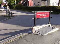
- Bicycle lift in Trondheim

Valley station
Mountain station

view from above


Public transport in Trondheim is operated by the private tram Gråkallbanen and the regional transport company AtB (since 2009). Trondheim is the landing stage for Hurtigruten ships and a catamaran ferry for passenger transport, which offers fast connections to Kristiansund several times a day . The Trondheim Airport -Værnes numbered about 4.2 million passengers in the year 2018th Trondheim is the terminus of the Dovre Railway , which connects Trondheim with Oslo, and the Trondheim – Storlien (Meråkerbahn) railway . Trains here are operated by Vy .
Due to the river Nidelva, the port and various canals, Trondheim also has a larger number of bridges of different construction.
Trondheim has a bicycle lift that pushes cyclists up the initially steep incline to the fortress. Inner- city traffic is also supported by a number of city bike stations ( Bysykkel ), similar to those in Helsinki .
Town twinning
Trondheim maintains city partnerships with
|
|
Personalities
Well-known personalities born in Trondheim include the composer Ludvig Mathias Lindeman , the politician Jo Benkow , the writer Erlend Loe , the cross-country skier Marit Bjørgen , cross-country skier Johannes Høsflot Klæbo and the biathlete Emil Hegle Svendsen .
Web links
- Official website of Trondheim Municipality (Norwegian)
- Official website of the city of Trondheim (Norwegian, English)
- Drontheim . In: Meyers Konversations-Lexikon . 4th edition. Volume 5, Verlag des Bibliographisches Institut, Leipzig / Vienna 1885–1892, p. 155.
- Adresseavisa - local newspaper (Norwegian, English)
- Norges Teknisk-Naturvitenskapelige Universitet (NTNU) (Norwegian, English)
- Sør-Trøndelag University College (English, Norwegian)
- Classicism in Trondheim. A contribution to Norwegian wooden architecture by Helmut Auener, Marburg, 1949
Individual evidence
- ↑ Statistisk sentralbyrå - Befolkning
- ^ Risvaag, Jon Anders: Mynt Og by: Myntens Rolle I Trondheim by I Perioden Ca. 1000-1630, Belyst Gjennom Myntfunn Og Utmynting . Ed .: Norges Teknisk-naturvitenskapelige Universitet Institutt for Arkeologi Og Religionsvitenskap. 2006 ( exlibrisgroup.com ).
- ↑ Statistisk sentralbyrå (Norwegian)
- ↑ Navn på nye kommuner. February 19, 2019, accessed January 22, 2020 (Norwegian).
- ↑ http://archiv.ub.uni-marburg.de/ubfind/Record/urn:nbn:de:hebis:04-eb2018-0082 , p. 48
- ^ Website of the Norwegian Tourist Office . Retrieved June 6, 2013.
- ^ Synagogues at extreme latitudes ( Memento from March 31, 2013 in the Internet Archive ) Alnakka.net, accessed on November 5, 2012
- ↑ Passengers 2018. (XLSX; 28 KB) In: Statistics - Avinor. Avinor , accessed April 28, 2019 (English, Norwegian).
- ↑ Internasjonalt work. Trondheim Municipality, accessed April 22, 2019 (Norwegian).
Flatanger | Frosta | Frøya | Grong | Home | Hitra | Holtålen | Høylandet | Inderøy | Indre Fosen | Leka | Levanger | Lierne | Malvik | Melhus | Meråker | Midtre Gauldal | Namsos | Namsskogan | Nærøysund | Oppdal | Orkland | Eyelets | Overhalla | Rennebu | Rindal | Røros | Røyrvik | Selbu | Skaun | Snåsa | Steinkjer | Stjørdal | Trondheim | Tydal | Verdal | Ørland | Åfjord