Meråker
| coat of arms | map | |
|---|---|---|

|
|
|
| Basic data | ||
| Commune number : | 5034 | |
| Province (county) : | Trøndelag | |
| Administrative headquarters: | Meråker | |
| Coordinates : | 63 ° 25 ' N , 11 ° 45' E | |
| Surface: | 1,273.94 km² | |
| Residents: | 2,422 (Feb 27, 2020) | |
| Population density : | 2 inhabitants per km² | |
| Language form : | Bokmål | |
| Postal code : | 7530 | |
| Website: | ||
| politics | ||
| Mayor : | Kjersti Kjenes (Meråker Tverrpolitiske Bygdeliste) (2019) | |
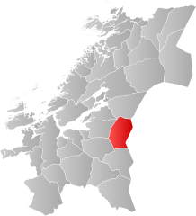
| Location in the province of Trøndelag | ||

|
||
Meråker is a Norwegian municipality in Trøndelag . It borders Sweden to the east .
The name is derived from the old word for "horse" = merr and åker = "field". In 1850 Stjørdal was divided and Meråker and Hegra became Øvre Stjørdal. On January 1, 1874, the municipality "Øvre Stjørdal" was again divided into Meråker and Hegra, which were initially independent, then on January 1, 1962, Hegra became part of Stjørdal.
Meråker used to be a mining area , as the mine hunt shows in the coat of arms, and is now a climatic health resort.
Sons of the commune
- Anton Fridrichsen (1888–1953), theologian
- Helge Ingstad (1899–2001), archaeologist
- Magnar Lundemo (1938–1987), cross-country skier and track and field athlete
- Anne Kathrine Slungård (* 1964), politician
Individual evidence
