Inderøy
| coat of arms | map | |
|---|---|---|

|
|
|
| Basic data | ||
| Commune number : | 5053 | |
| Province (county) : | Trøndelag | |
| Administrative headquarters: | Straumen | |
| Coordinates : | 63 ° 53 ' N , 11 ° 13' E | |
| Surface: | 365.67 km² | |
| Residents: | 6,816 (Feb 27, 2020) | |
| Population density : | 19 inhabitants per km² | |
| Language form : | neutral | |
| Postal code : | 7670 | |
| Structure: | Kjerknesvågen, Røra, Sandvollan, Sakshaug, Utøy, Straumen, Mosvik, Framverran | |
| Website: | ||
| politics | ||
| Mayor : | Ida Stuberg ( Sp ) (2011) | |
| Location in the province of Trøndelag | ||

|
||
Inderøy is a Norwegian municipality in Trøndelag . It lies on a peninsula that is enclosed by the Beitstadfjord in the north, the Trondheimfjord in the south and the Borgenfjord in the east. It is located 105 km from Trondheim . It is the most densely populated municipality in the entire district. On January 1, 2012, the previously independent municipality of Mosvik was incorporated into Inderøy.
Inderøy belongs to the Frostathing , originally a legislative body, today only the judicial district of the middle instance.
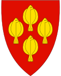
The coat of arms contains four clods on a red background. The plaice caught in the fjord is Inderøy's local specialty.
Sons and daughters of the commune
- Harald Skjervold (1917–1995), animal breeding scientist
Individual evidence
Web links
Commons : Inderøy - collection of images, videos and audio files
