Flatanger
| coat of arms | map | |
|---|---|---|

|
|
|
| Basic data | ||
| Commune number : | 5049 | |
| Province (county) : | Trøndelag | |
| Administrative headquarters: | Lauvsnes | |
| Coordinates : | 64 ° 30 ' N , 10 ° 54' E | |
| Surface: | 458.71 km² | |
| Residents: | 1,103 (Feb 27, 2020) | |
| Population density : | 2 inhabitants per km² | |
| Language form : | neutral | |
| Website: | ||
| politics | ||
| Mayor : | Olav Jørgen Bjørkås ( Sp ) (2011) | |
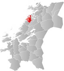
| Location in the province of Trøndelag | ||

|
||
Flatanger is a Norwegian municipality in Fylke Trøndelag with 1103 inhabitants (as of February 27, 2020). The seat of the administration is in Lauvsnes .
Attractions
Utvorda Fortress was built during World War II and was Norway's largest coastal fort. The Villa Fyr lighthouse on the island of Villa was built in 1839.
Sports
In 2012 Flatanger became known for the first ascent of the most difficult climbing routes, which are located in the “Hansehellaren” cave near the village. Two of the most difficult routes in the world at the moment are located near Flatanger. The route " The Change " ( 9b + / XII− ) was first climbed in October 2012 by the Czech Adam Ondra . In September 2017, Ondra managed the " Silence " route. The rating 9c (XII) proposed by him has not yet been confirmed.
Web links
Individual evidence
- ↑ Statistisk sentralbyrå - Befolkning
- ↑ Kystriksveien FV.17: Steinkjer-Bodø, published by Kystriksveien Reiseliv as, 2014
- ↑ Adam Ondra climbs first 9c! alpin.de, September 4, 2017
- ↑ NEWSFLASH: Adam Ondra climbs World's first 9c? - Project Hard , ukclimbing.com, September 3, 2017
