
Handnesøya
| Handnesøya | |
|---|---|
 |
|
| Waters | European Arctic Ocean |
| Geographical location | 66 ° 16 ' N , 13 ° 2' E |
 |
|
| length | 13.3 km |
| width | 4.4 km |
| surface | 34.4 km² |
| Highest elevation | Stokkatinden 599 m |
| Residents | 120 3.5 inhabitants / km² |
| main place | Handnes |
Handnesøya is a Norwegian island in Nesna municipality in Nordland province . The island at the mouth of the Sjona Fjord is named after the Handnes farm . The original name is probably based on the term hand , which indicates the shape of the mountain ranges. The highest point is the Stokkatinden mountain at almost 600 meters . Around 120 inhabitants live on the 34.4 km island (as of 2001). The development is concentrated along the coastal road in the southeast and west. The Handnesøya kapell, a small wooden chapel with 70 seats and dating from 1969, is available to residents . The island is connected to the mainland by a ferry from Nesna, the capital of the municipality of Nesna.
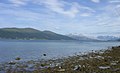
North-eastern part of the island

View from the southwest
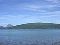
View from Nesna to the southwest. In the background the Tomskjeveln mountain on Tomma


Web links
Individual evidence
- ↑ a b Store Norske Leksikon: Handnesøya , accessed on September 24, 2010 (Norwegian)
- ↑ Reuber - Norway: Nesna commune: Sights at a glance , accessed on September 24, 2010 (German)