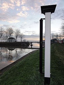
Hunsingokanaal
The Hunsingokanaal is a drainage canal built in 1873 in the northwest of the Dutch province of Groningen , which runs from the area around 't Stort past Leens and Ulrum to Zoutkamp . At 't Stort the canal divides and continues as Hoornse Vaart to the north and as Warfhuisterloopdiep to the east. In the west, the Hunsingokanaal connects to the Zoutkamperril (continuation of the Reitdiep ), which flows into the Lauwersmeer .
The 6.6 km long canal was built to the drainage of the land part Marne , part of the Frisian Gaus Hunsingo to improve that today the municipality De Marne covers. It is passable for boats. The construction was made possible in 1852 by the establishment of a Waterschap , the Dutch form of local self-government for water management. It emerged from the predecessor organizations of the Zijlvesten , namely the Houwerzijlvest and Schouwerzijlvest , which at the time covered the Hunsingo area.
A connection was made between the center of Hunsingo and a drain to the west. It started with the piece between Zoutkamp and Ulrum , which was given the name Zoutkampertocht (in German: Zoutkamper Fahrt), until the canal was later extended to 't Stort. Finally, a sewer (Dutch term: spuisluis ) was created at the dike in Zoutkamp . The resulting canal got the name of the executing water board. The lock was named Hunsingosluis .
The drainage of the area around De Marne was greatly improved by the Hunsingokanaal. But it was not until the 20th century that a barrage , the HD Louwes-Sluis , was added to the canal (named after the politician HD Louwes (1893–1960)). This plant is managed by the Waterschap Electra , which also operates the De Waterwolf pumping station in Oldehove . In its function as a drainage structure , the Hunsingokanaal is a tributary of the Reitdiep , the main drainage artery of today's Waterschap Noorderzijlvest .
The following bridges, also called Til in Dutch, span the canal (from east to west), Leenstertil , Ulrumertil , Zuidema's klap and the Hunsingobrug (at the lock). In the 1980s, a crossing for cyclists was built near Zoutkamp.
Coordinates: 53 ° 21 ′ 14 ″ N , 6 ° 20 ′ 15 ″ E

