
Zoutkamp
| province |
|
| local community |
|
|
Area - land - water |
1.23 km 2 1.09 km 2 0.14 km 2 |
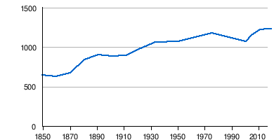
| Residents | 1,220 (Jan. 1, 2017) |
| Coordinates | 53 ° 20 ′ N , 6 ° 18 ′ E |
| Important traffic route |
|
| prefix | 0595 |
| Postcodes | 9885, 9971-9972, 9974-9976 |
| Website | Homepage of Zoutkamp |
 |
|
Zoutkamp ( Gronings Zoltkamp or Soltkamp ; West Frisian Sâltkamp ) is a place in the Dutch municipality of Het Hogeland and belongs to the province of Groningen . The town bordering the province of Friesland had 1,220 inhabitants in 2017. The name ( German "Salzfeld" ) refers to its location on the former Lauwerszee , now the Lauwersmeer due to dykes .
history
The first mention of the place comes from the year 1418, when a resident of Soltcampum was named. The location, consisting of sol , derived from the Latin salis for salt, and the equally Latin word for field may indicate the artisanal extraction of salt within the dykes. A German equivalent would be the word Salzwiese . Similar to the neighboring town of Kommerzijl , this branch of industry experienced its decline in the Eighty Years' War .
fortress
Zoutkamp is strategically located at the mouth of the Reitdiep , which flows into the Lauwerszee there; Until the completion of the Eemskanaal in 1876, this was the only sea access to the city of Groningen . A Spanish garrison camped here during the Eighty Years' War. 1576 for their protection was Soltecampe - ski jump built. In the following years from Friesland, which was already under the administration of the later Republic of the Seven United Provinces , plundering trips were carried out through Wassergeusen that affected all places around Zoutkamp. The villages Warfhuizen and Zuurdijk were burned down. As part of the Dutch uprising , plans were developed to conquer the well-fortified forts and defenses in the so-called Ommelande in order to be able to take the city of Groningen more easily. On October 5th, 1589 Willem Lodewijk sailed from Oostmahorn with 800 men to Soltkamp and liberated the place in the battle for Zoutkamp . After that it remained a fortified garrison place for many years. Around 1600 the village had its own pastor and probably also a garrison church .
The fortifications were important until the end of the 17th century. However, at the end of the 18th century, at the beginning of the French occupation , the hill was in serious disrepair. In order to have adequate protection against a possible English attack, a garrison was moved there from France in 1799 and the hill was restored. For this purpose, a bastion was built on the east side, which also had a coastal battery . A barracks was built, which was rededicated in 1832 as a hospital for lepers. With the passing of a new defense law in the Netherlands, the old fortifications and military structures in Zoutkamp were no longer needed towards the end of the 19th century. In 1879 the ammunition depot was razed and in 1882 the entire fortification was lifted.
economy
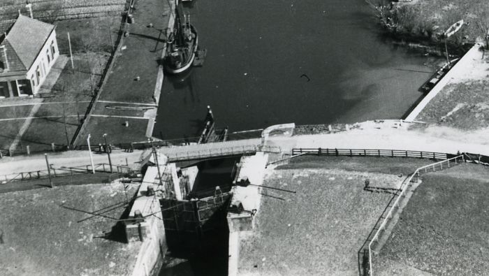
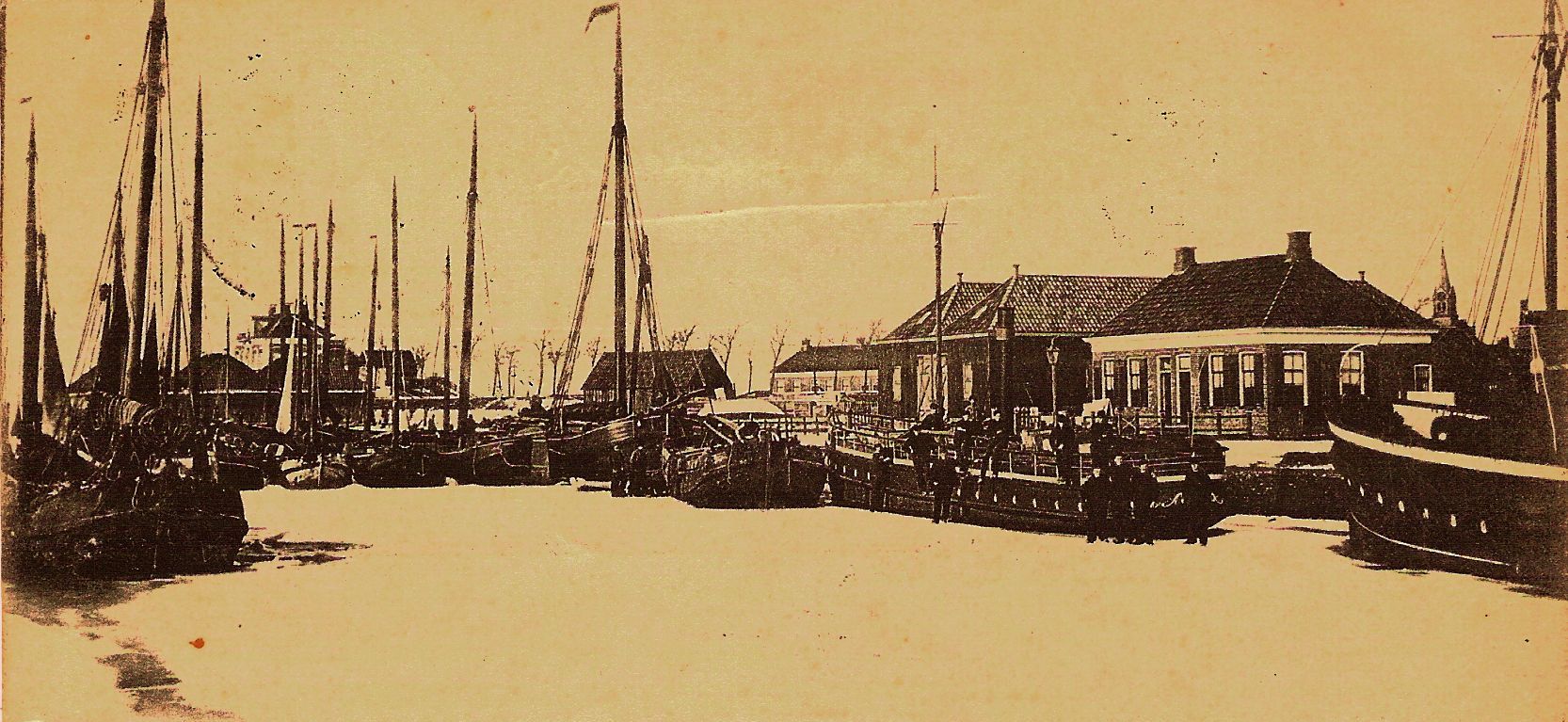
Zoutkamp has always been managed from Vierhuizen and Houwerzijl . At the turn of the 18th century, fishermen lived in the old ski jump. The baptismal register of the Reformed Church of Vierhuizen, which was only created in 1673, shows two to three baptized children from Zoutkamp annually from this point onwards. By 1750 there were already five or six and by 1800 around fifty. In 1756 there were 25 houses in Zoutkamp. The settlement consisted of organically grown streets with houses built close together. After a fishing port was established in 1825, the population continued to grow, so that in 1836 a separate church, the Kerk van Zoutkamp , was built. It stands on the place of the "old battery". Around 1850, when the place of the coastal guns , the Small Battery (on the north side of the Hunsingoweg and Spuistraat), was demolished, the place had about 25 fishing boats landing flounder , dab , haddock and plaice . At that time the place already had 660 inhabitants. In 1858 the Hunsingokanaal was dug (initially only to Ulrum ) and the Hunsingosluis (lock) was built. Thanks to this better access for shipping, the economic situation of the place improved. At the lock, an inland port was built in 1880 on the former Kleine Schans . To the south there was a poor house (“De Barak”), which was demolished in 1930. The Zoutkamper were nicknamed "Schelleviskoppen" ("haddock heads") or "Vlintkoksems" at that time.
Zoutkamp's industry concentrated on fishing, with women also finding work in the factories. In the 19th century there was a living mussel fishery for the lime kilns , which were built in the 1860s by the Zoutkamp entrepreneur Woldring (h) along the recently created Hunsingokanaal. The two lime kilns, together with the towers of the two churches and the mill, dominated the village landscape around 1900. Woldring also built a shipyard (closed in 1900), a Portland cement factory and a steam-powered sawmill .
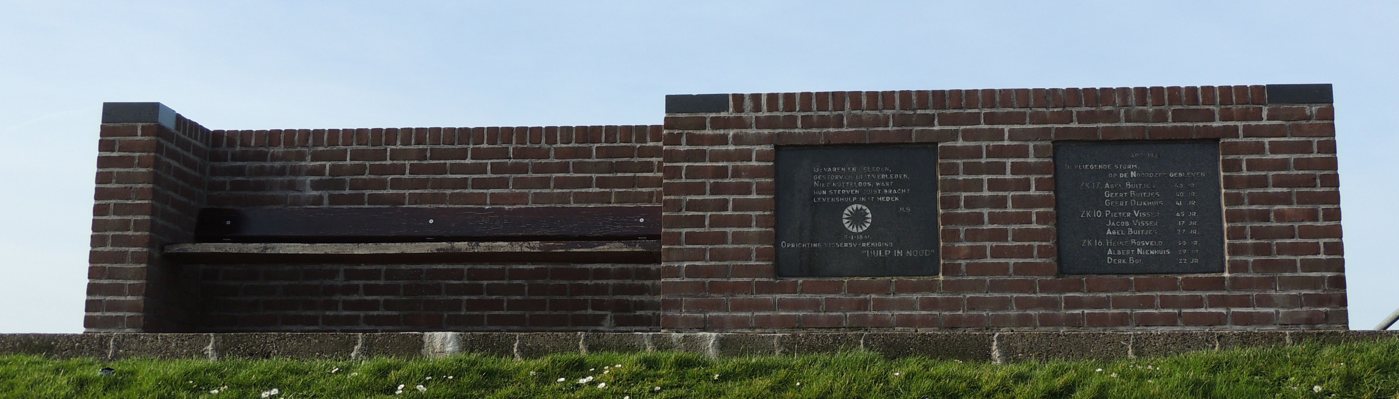
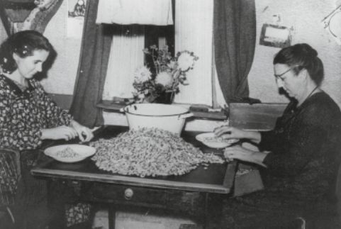
In the second half of the 19th century, with the further growth of the population, not all residents could live from the previous economy. Quite a few Zoutkamper moved to other fishing villages or hired on non-local fishing boats. Three of these ships went down in the storm surge from Paesens-Moddergat on the night of March 5th to 6th, 1883 and tore nine Zoutkampers to their deaths. A total of 83 people died in this flood; 17 boats were lost. However, the fishing industry in Zoutkamp strengthened again with the advent of shrimp fishing , accelerated in the 20th century by the advent of fast, motor-driven trawlers . In the village some crab dehydrators emerged and Krabbenpulen in homework developed for housewives and children as a good additional income during the interwar period. Between 1930 and 1933 a large harbor basin was laid out and a fish hall was built.
Zoutkamp also owned some of the windmills that are so characteristic of the Netherlands. The last two were built in 1822 and 1852, but both burned down in 1933 and devastated many adjacent buildings. Opposite Zoutkamp, a parallel drainage was dug to drain the Reitdiep and to protect Zoutkamp from flooding , which was an extension of the Lauwers. It was supported by a wind-driven pump from 1910. It was located on the narrow current dam between Lauwers and Reitdiep and was demolished in the 1950s.
Traffic routes
Until 1877, Zoutkamp owned a ferry connection across the Reitdiep. In the same year a dike (Provinciale dijk) was built between Zoutkamp and Nittershoek to protect the land towards the Lauwerszee. This is where the Groote Provinciale sluis , nicknamed the “Gate to Groningen”, is located. Thanks to this lock, Zoutkamp was given a bridge connection (Reitdiepbrug). This connection lifted the isolation of the place further. The fishing boats were moored in the inland port, and later the ferry to Schiermonnikoog (via Oostmahorn ) was added. Between 1887 and 1906 the 25-meter-long paddle steamer Sophia was used for this purpose under Captain Brands. The ship, designed for 160 passengers, also went to Groningen. After the Lauwerszee ended in 1969, the Zoutkamperril Canal was created , previously only the flat, albeit navigable, continuation of the Reitdiep into the Lauwerszee.
At the beginning of the 20th century there was a stagecoach connection between Zoutkamp and Winsum . In 1922, however, the Winsum - Zoutkamp railway line was completed, allowing travelers from Zoutkamp station to travel to the city of Groningen much faster (change in Winsum). Passenger traffic was taken over in 1938 by the Marnedienst transport association, which was founded in the same year and is based in Zoutkamp.
Second World War
During the Second World War , the place was occupied by 80 to 100 German soldiers of the Wehrmacht , who among other things built large barracks between the two locks. The railway line was dismantled by the German occupiers in 1942 for replenishment on the Eastern Front ; the still preserved station building of Zoutkamp (Stationsstraat 8) was converted into a luxurious residential building after a fire in 1975. The Provinciale Weg in the direction of Winsum is now on a section of the former railway line .
The Reitdiep wharfs were hit by two Allied aerial bombs; the bridge over the river was blown up towards the end of the war. On April 15, 1945, Zoutkamp was liberated from the German occupiers by Canadian troops .
Zoutkamp today
fishing
Zoutkamp was a fishing village until the 1960s . But after the Lauwersmeer was closed against the will of the Zoutkamper (comparable to the Zuiderzee closing dike), the fishing port was relocated to Lauwersoog. Dozens of fishing trawlers and local shrimp fishermen found their new berth there. The Zoutkamp (ZK) fishing license was retained . A new auction hall was also built there. This eliminated a large part of the hustle and bustle and life in the alleys of the village and Zoutkamp experienced a decline until the 1980s. On the occasion of the 50th anniversary of the closure of the waters, an old fisherman and board member of the local fisheries museum spoke of a 'memorial day' rather than a 'celebration'.
The port of Zoutkamp was of great importance for the shrimp fishery. Two companies, Heidema ( fish meal , animal feed made from crab scraps and ship's provisions) and Van der Ploeg (courier services) were founded as early as 1900 . After the Second World War, it was decided to work together and merged into the Heiploeg company . It was family-run until the end of the 1980s and built a plant outside of Zoutkamp, which for some time was the largest crab processing facility in Europe. It employs 300 Zoutkampers and is now part of the Irish food company Greencore . One section of the company is located in the port of Laueroog. As is customary in the industry these days, the shrimp peeling is carried out by external providers in Morocco.
reconstruction

After the war, many of the houses in the old village were damaged or derelict. In 1956, the Ulrum municipality therefore decided to completely renovate the entire center, which meant that from 1960 onwards, many of the small fishermen's houses from the 18th and 19th centuries were demolished. Or as an Ulrum council member said at the time: “Zoutkamp, the bulldozer has to go through there”. However, thirteen houses were "saved" and rebuilt in 1973 in the outdoor area of the Zuiderzee Museum in Enkhuizen . Only a little of the old buildings in Zoutkamp has been preserved in the old Visserstraat in the center of the village. Most of the Zoutkampers were quite happy with the demolition of the small, dilapidated houses, as they were replaced by larger houses and a main street and a shopping center were built. The village renewal was supplemented by the construction of a marina to promote tourism. A new housing estate was built northeast of the village.
Leisure and Tourism

.jpg)
The move of the Heiploeg crab factory from the town center to the north of Zoutkamp created a larger open space within the town. The municipality of De Marne, which was restructured in 1990 (part of the municipality of Het Hogeland since 2019) took up this opportunity and carried out another renovation of the old town. For this purpose, first the quays, then the inland port and finally the village center were redesigned. The Reitsdiepkai got a promenade and restaurants, and in 1994 opened on the site of a former state buoys bearing the Visserijmuseum Zoutkamp (Fishing). The port of Zoutkamp is still shaped by the tradition of shrimp fishing, and so there is a large shrimp wholesaler at the end of the quay. At the turn of the millennium, Zoutkamp was further attractively redesigned. Part of the former fortifications of Soltkamp was exposed and the shopping center was given a new look. A few years later, the sleeping dike was pierced to make the area of the Hunzegat marina , which was also given a facelift, more easily accessible from the village side.
The transformation of the place into a tourist magnet bore fruit. The number of visitors has risen sharply since the completion of the Esonstadt amusement park west of the Lauwersmeer . The port has been an important berth for the ships of the Brown Fleet since the late 1980s . Water sports enthusiasts and day trippers in particular head for Zoutkamp, especially on weekends. There are two campsites and a recreation complex near the village.
Every year there are festivities around the theme of fishing. Since 1958, Zoutkamp has also had its “Vlaggetjesdag” (originally a traditional festival about getting the fishing boats ready for the fishing season in Scheveningen ). These festivals attract tens of thousands of visitors every year. Since 2007, the battle for Zoutkamp has been re- enacted every four years in September .
military
In the Reitdiep before Zoutkamp, ammunition ships of the Dutch Navy were anchored until the 1960s . From 1970 to 2008 there were also two listening devices of the National Signals Intelligence Organization , or NSO for short (not to be confused with the Netherlands Space Office , also NSO for short), under the name "Grondstation Zoutkamp", for eavesdropping on Intelsat telephone traffic. After protests by local residents in the run-up, the Ministry of Defense did not receive permission from the Raad van State to expand the ground stations ("bowls"). It then moved it to the It Grutte Ear site near Burum .
In 1987, a guard of the Koninklijke Marechaussee (comparable to the German Federal Police ) was set up in Zoutkamp . However, this was lifted again in 1999. In 2008, after renovation, the building was again made available to a Marechaussee department, called Waddengebied , as headquarters, which is more staffed than the departments in Harlingen , Leeuwarden and Delfzijl .
Demographics
|
|
building
Churches
In Zoutkamp there is a reformed church from 1836, built in neoclassical style, on the site of the former battery . The services were accompanied by a harmonium for decades , and it was not until 1978 that the church received a church organ. This 150 year old organ was procured from a church in Veendam . Adjacent to the church, a cemetery was created in 1876, but it soon became too small and therefore the current cemetery was set up outside the village in 1882.
In 1882 an old reformed church was built, which was replaced in 1969 by the new church "Het Anker" built four years earlier. From 2006 it is used as a Protestant church. The previous Reformed Church has not been used for church services since then and is now a multicultural center.
schools
A first school was set up by the villagers themselves in 1827. Around 15 years later, a new school building was erected. In the course of time a public, a Christian (at least until 1970) and a reformed elementary school have emerged. The latter has since been closed and now houses a bicycle and moped museum . Today's Solte Campe public primary school was established in 1982. There is also the Christian Ichthus School .
Attractions

.jpg)
Apart from the reformed church (today a cultural center), there is little of the historical structure left in Zoutkamp. In addition to two rebuilt houses behind the fishing museum, only a few old fishermen's houses can be seen in Visserstraat. The former lock keeper's house 'De Batterij' stands on the dike, built around 1880. The fishing museum has been built on Reitdiepkai since 1994 in a wooden warehouse for concrete material (with hipped roof ) from 1875; connected is the Lauwersland tourist office established there . In the center of the village is the hotel 'De Zeearend', which was built in 1929 in an architectural style that was new at the time, strict and factual. At the lock of the Hunsingokanaal (Hunsingosluis) there is a simple wooden lock keeper's house from 1859. Another house for lock keepers is at the Reitdiep lock, built in 1877, which was later used as a port office. The "old Fährhaus", a striking white building that served as a popular photo motif, was also located on the Reitdiep. In 1840 it was still used as a herring smokehouse , and in 1970 it was converted into a holiday home.
See also
- ZK 14 - Aak usedby Martin Luserke (1880–1968) as a floating poet's workshop , acquired in Zoutkamp from Betto and Maarten Bolt in 1934
Web links
- Information about Zoutkamp and also its history (Dutch)
- Information about the fishing museum (Dutch, with a German and English information page)
Individual evidence
- ↑ a b Kerncijfers wijken en buurten 2017 Centraal Bureau voor de Statistiek , accessed on June 27, 2018 (Dutch)
- ↑ Document from 1418 , on: zoutkamp.net, accessed on August 12, 2017.
- ↑ Geschiedenis on: zoutkamp.net, accessed on 12 August 2017th
- ^ Reformed Church , on: zoutkamp.net, accessed on August 12, 2017.
- ↑ Hunsingokanaal 1955 , on: zoutkamp.net, accessed on August 12, 2017
- ↑ Hunsingoluis 1928 , on: zoutkamp.net, accessed on August 12, 2017.
- ↑ Hunsingosluis 1950 , on: zoutkamp.net, accessed on August 12, 2017.
- ↑ Inland port , on: zoutkamp.net, accessed on August 12, 2017.
- ↑ old nicknames for Zoutkamper, on: dideldom.com
- ↑ Nicknames for Zoutkamper , on: niederlande-wegweiser.de, accessed on August 12, 2017.
- ↑ Fischerdenkmal Zoutkamp , on: zoutkamp.net, accessed on August 12, 2017.
- ↑ Garnelenpulen in Zoutkamp 1935 , on zoutkamp.net, accessed on 12 August 2017th
- ↑ Details of the sold "Polder Mill" opposite Zoutkamp
- ↑ a b Schuttevaer - Woede over het meer is niet verdwenen - Actueel . July 3, 2013. Archived from the original on July 3, 2013.
- ↑ Nina van den Broek (2007), "Zoltkamp, doar mout de bulldozer deur; Het saneringsbeleid van de gemeente Ulrum". In: Bedreigd Verleden; Small monuments en de strijd voor hun behoud . Groningen: Verlag Passage. Pages: 99–101.
- ^ Brigade Koninklijke Marechaussee Zoutkamp. MarechausseeSporen, archived from the original on June 11, 2009 ; Retrieved May 30, 2017 (Dutch).
- ↑ Dutch Censuses 1795-1971 ( English ) igital Archiving and Networked Services. Retrieved April 2, 2019.