
Ingapirca

Coordinates: 2 ° 32 ′ 54.9 ″ S , 78 ° 52 ′ 18.9 ″ W.

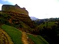
Ingapirca ( Inkapirka , Kichwa : "Inka Wall"), also Hatun Kañar ( Hatun Cañar , "Greater Cañar") is the most important Inca site in Ecuador . It is located about 50 km north of Azogues in the parish of Ingapirca in the canton of Cañar in the province of Cañar .
The exact purpose of the complex, which the Spanish chroniclers of the Conquista called “castle” ( castillo ), has still not been deciphered. In the meantime, however, it has become clear that it was not just a fortress, but also a cult site of the Kañari , which was later used and expanded by the Inca as well. The construction of the jointless joining of large hewn stone blocks is similar to the Inca ruins preserved in Cuzco . According to current interpretation, the complex includes a sun temple , an observatory for observing the sun and moon , storage rooms, ritual baths, tombs, streets and squares.

Ingapirca ruins

Side view of the ruins
Cliff down into ruin

Ingapirca Palace


