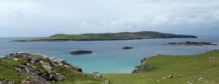
Inishark
| Inishark | ||
|---|---|---|
| Waters | Atlantic Ocean | |
| Geographical location | 53 ° 36 '42 " N , 10 ° 16' 54" W | |
|
|
||
| length | 2.6 km | |
| width | 1.4 km | |
| surface | 2.49 km² | |
| Highest elevation | 100 m | |
| Residents | uninhabited | |
| Inishark on the map in the southwest | ||
Inishark or Inishshark ( Irish : Inis Airc; German "Island of the sea monster" ) is a small island off the west coast of the Republic of Ireland in County Galway , which has been uninhabited since 1960 . The treeless island is less than 1000 meters west of the larger neighboring island of Inishbofin .
The island had 208 inhabitants in 1841 and 26 before the 1960 evacuation. The last of the families were relocated to Fountain Hill near Claddaghduff, near Clifden . One house is still used by fishermen. There is a small cemetery at the landing stage. The first people came to the island more than 6000 years ago.
description
The island is 2.6 km long from east to west, and a maximum of 1.4 km wide, with an area of 2.49 km².
Attractions
- St. Leos Chapel is an abandoned chapel from the 19th century, which was built over the former "Teampaill Leo" chapel, which is associated with the saint of the island. In Leo's Cove or Fó Leo (Fó denotes a small cove) is a sacred spring .
- Clochan Leo, a ruined stone hut with traces of a round enclosure, is attributed to the saint "Leaba Leo". The saint's bed, or tomb, appears to be the little hill northeast of the hut.
- A destroyed clochán gave the small bay Fó Chlochain its name. Nearby is "Poll ant tSéidte" a blowhole .
- At Dúinin there are traces of a Promontory Fort .
- "Aill an Chlai" at the southwest end of Inishark is an approximately 460 m long wall, between the caves "Aill na nUibheacha" on the northwest side and "Fó Duilisc" in the southeast, which cuts off the southwest end of the island. It originally consisted of a four-meter-wide earth wall, which was faced with a dry stone wall and only later covered with stones. There are multi-period hut tracks in the area of the wall and a ditch. While the stone cover could be from the 19th century, the original rampart likely came from a Promontory fort . An old field system lies in the southwest.
flora
Grasses, irises, swamp thistles, red clover and moss cover Inishark and thyme grows everywhere.
literature
- Tim Robinson: Connemara Part 1: Introduction and Gazetter Roundstone . 1990, ISBN 0-9504002-5-4 .
- Paul Gosling: Archaeological Inventory of County Galway . Vol. 1: West Galway (including Connemara and the Aran Islands) . Stationery Office, Dublin 1993, ISBN 0-7076-0322-6 .


