
Ironstone Mountain
| Ironstone Mountain | ||
|---|---|---|
 |
||
| height | 1444 m | |
| location | Tasmania | |
| Coordinates | 41 ° 43 '0 " S , 146 ° 30' 0" E | |
|
||
| particularities | highest mountain in the Great Western Tiers | |

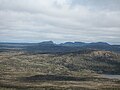
The Ironstone Mountain is a mountain in the Great Western Tiers , a mountain range in the center of the Australian state of Tasmania . It is located approximately 18 km south of Mole Creek . At 1,444 m, it is the highest mountain in the Great Western Tiers. There is a small lake nearby, Lake Ironstone . The highest point is marked by a trigonometric point , but the signal peak shown here is more striking.
The network coordinates in the UTM coordinate system are 563819 UTM Zone 55S and a high-resolution topographic map (1: 25,000) is available from Tasmap (Lake Mackenzie (No. 4438)).
Ascent
Ironstone Mountain is mainly accessible via two hiking trails. The shortest ascent is the one from the north via Mole Creek, Caveside and Westrope Road to the Western Creek Track , which runs along the east side of the Western Creek valley. Another ascent option is from the east via Deloraine , Meander, and Smoko Road to the Mount Ironstone Track . This trail begins 2 km south of Mother Cummings Peak , another mountain in the area.
Gallery images

Lake Ironstone

Contrails over Ironstone Mountain
Walls of Jerusalem National Park from Ironstone Mountain


