Ishima (Tokushima)
| Ishima | ||
|---|---|---|
|
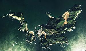
Aerial photo of Tanago-jima, Mae-jima and Ishima (from left to right), 1976. The Ishima swamp is clearly visible as a brown spot. |
||
| Waters | Kii canal | |
| Geographical location | 33 ° 50 '50 " N , 134 ° 48' 50" E | |
|
|
||
| length | 2 km | |
| width | 1.5 km | |
| surface | 1.45 km² | |
| Highest elevation | Noroshi-yama 124 m |
|
| Residents | 190 (2014) 131 inhabitants / km² |
|
| main place | Ishima-cho | |
Ishima ( Japanese 伊 島 ) is a Japanese island in the Kii Channel of the Seto Inland Sea . It belongs administratively to the Anan Township of Tokushima Prefecture .
geography
The 1.45 km² large island is located at the southern end of the Kii Channel and represents the most easterly point of the Shikoku islands. The highest point is the 124 m high Noroshi-yama ( の ろ し 山 ) in the east of the island, on which towards the end of the Edo period (19th century) there was a beacon ( noroshi ) that warned of the arrival of foreign ships. Today there is a lighthouse there.
Separated by a 200 m wide channel is located in the West Island Maejima ( 前島 ; 33 ° 50 '30 " N , 134 ° 48' 13" O ) and 30 m northwest of this Tanago-jima ( 棚子島 ; 33 ° 50 ' 45 " N , 134 ° 47 '53" E ). 10 m southeast of Ishima is the island of Mizushima ( 水 島 ; 33 ° 50 ′ 35 ″ N , 134 ° 49 ′ 10 ″ E ).
Administratively, the islands belong to the district Ishima-chō of the municipality of Anan. The 190 inhabitants (2014) live in the northwest of Ishima, while Maejima only has port facilities.
nature
In the north-west of the island there is a swamp area that is home to rare insect species and has therefore been named one of the "500 most important swamps in Japan" by the Ministry of the Environment .
The island is also the only habitat of a form of Lilium japonicum ( Ishima-Sasayuri ). Until a few decades ago, the hills of the island were covered with pink lilies, as the inhabitants alternately cleared individual hill slopes for firewood every 20 years and created a habitat for them, while the previously cleared ones were naturally reforested in the meantime. With the conversion to natural gas, this was no longer available and the forests became overgrown, with the lilies losing their habitat. Today it is a tradition for students at the island's middle school to preserve the lily populations and sell lilies to the islanders to fund their school trips.
Individual evidence
- ↑ a b c d 離島 で 過 ご す 最高 の 週末 . (PDF) (No longer available online.) Anan, archived from the original on July 24, 2015 ; Retrieved July 24, 2015 (Japanese). Info: The archive link was inserted automatically and has not yet been checked. Please check the original and archive link according to the instructions and then remove this notice.
- ↑ a b 伊 島 . In: 日本 大 百科全書 at kotobank.jp. Retrieved July 24, 2015 (Japanese).
- ↑ Katsuro Arakawa: The conservation of wild lily populations in Japan . In: Caroline Boisset (Ed.): Lilies and Related Plants 2007–2008 . 75 th Anniversary Issue. The Royal Horticultural Society Lily Group, ISBN 978-1-902896-84-7 , pp. 11-12 ( rhslilygroup.org [PDF]).

