Anan
| Anan-shi 阿南 市 |
||
|---|---|---|
|
|
||
| Geographical location in Japan | ||
| Region : | Shikoku | |
| Prefecture : | Tokushima | |
| Coordinates : | 33 ° 55 ' N , 134 ° 40' E | |
| Basic data | ||
| Surface: | 279.39 km² | |
| Residents : | 70,057 (October 1, 2019) |
|
| Population density : | 251 inhabitants per km² | |
| Community key : | 36204-2 | |
| Symbols | ||
| Flag / coat of arms: | ||
| Tree : | Ume | |
| Flower : | Sunflower | |
| Bird : | Barn swallow | |
| town hall | ||
| Address : |
Anan City Hall 12 - 3 , Tonmachi, Tomioka-chō Anan shi Tokushima 774-8501 |
|
| Website URL: | http://www.city.anan.tokushima.jp | |
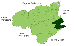
| Location Anans in Tokushima Prefecture | ||
Anan ( Japanese 阿南 市 , - shi ) is a city on the island of Shikoku in southern Japan . It belongs to Tokushima Prefecture .
The inhabited island of Ishima belongs to the municipality , as well as the neighboring islands of Maejima and Tanago-jima, which are five kilometers east of the Shikoku coast at the southern end of the Kii Channel .
history
The city of Anan was founded on May 1, 1958 .
Attractions
The 21st and 22nd temples of the Shikoku pilgrimage route , the Tairyū-ji and the Byōdō-ji are located in Anan .
traffic
- Rail:
- Street:
- Shikoku-ōdan Highway
- Anan Aki Highway
- National Road 55.195
Neighboring cities and communities
Personalities
- Genta Omotehara (* 1996), football player
Web links
Commons : Anan - collection of images, videos and audio files


