
Naruto (Tokushima)
| Naruto-shi 鳴 門市 |
|||
|---|---|---|---|
 |
|||
| Geographical location in Japan | |||
|
|||
| Region : | Shikoku | ||
| Prefecture : | Tokushima | ||
| Coordinates : | 34 ° 10 ' N , 134 ° 37' E | ||
| Basic data | |||
| Surface: | 135.45 km² | ||
| Residents : | 56.007 (October 1, 2019) |
||
| Population density : | 413 inhabitants per km² | ||
| Community key : | 36202-6 | ||
| Symbols | |||
| Flag / coat of arms: |
 |
||
| Tree : | Ilex integra | ||
| Flower : | Hibiscus hamabo | ||
| town hall | |||
| Address : |
Naruto City Hall 170 , Muya-chō, Minamihama, Aza Higashihama Naruto -shi Tokushima 772-8501 |
||
| Website URL: | http://www.city.naruto.tokushima.jp/ | ||
| Location of Narutos in Tokushima Prefecture | |||
 |
|||

Naruto ( Japanese 鳴 門市 , -shi ) is a city in Tokushima Prefecture on Shikoku Island in Japan .
geography
Naruto is located on the northeastern tip of Shikoku Island and on the three islands of Ōge-jima , Takashima and Shimada-shima in the northeast , separated from Shikoku by the Konaruto Strait. The urban area finds its natural limits in the east with the Kii Canal and in the north with the Harima-nada marine region the Seto Inland Sea . To the west rises the Sanuki mountain range in the area of the city ; however, a natural border with the neighboring town of Itano cannot be identified. The southern border is determined by the course of the Kyū-Yoshinogawa river .
The main settlement area of the city is on the northeastern section of the Tokushima Plain , a flat alluvial plain just above sea level. From there the easternmost tip of the Sanuki Mountains rises to the west. The hill country consists of folded sediments (sandstones and marls) of the Middle Cretaceous , which abruptly plunge into the subsurface in front of the city center and to the east only occasionally as flat, island-like hills (e.g. the 62 m high Myōken-zan) the younger alluvial sediments the Tokushima Plain.
This pattern continues similarly in the northeast of the urban area, but here in the form of a sequence of hilly islands and natural sea channels and bays. because the tidal exchange of water between the Seto Inland Sea and the Pacific Ocean , as well as the lack of sediment supply, did not result in extensive sedimentation. This was partly made up for by artificial landfill, for example in the Takashima district.
North of the urban area, the Naruto Strait extends between Cape Mago (Japanese Magozaki , "grandchildren's cape") on Ōge-jima and the island of Awaji . The tidal currents here are so strong, with speeds of up to 20 km / h, that huge ocean eddies form twice a day. Due to this increased erosion power , the few resistant rocks of the above mentioned. Izumi sequence (sandstones, marl) at this point deepened to over 80 m.
If you look at the rest of the urban area to the west of the main settlement, the city relief is divided into two parts: the north part with few settlements is covered over its entire length by the 10 to 15 km wide Sanuki hill country. The parallel plains between the Kyū-Yoshinogawa and the mountain border are part of the Tokushima plain. The transition between hilly and flat land is also abrupt here.
The transition to the narrow coastal strip to the inland sea north of the Sanuki mountainous region is just as abrupt.
Attractions

In the north of the city at Ōge-jima is one of the main attractions of the city, the Naruto whirlpools in the sea in "Naruto Street". They can be viewed by boat or via a viewing platform at the bottom of the Naruto Bridge .
In the Ōtsuka art museum in the immediate vicinity , over 1,000 copies of works of art from all over the world and all art eras are exhibited on tiles, including, for example, B. a true-to-scale replica of the interior of the Sistine Chapel .
By spring 2010, a museum in Naruto was also dedicated to the Japanese anthropologist and archaeologist Torii Ryūzō . The collection has been relocated to the Bunka no Mori cultural park in the nearby prefecture capital of Tokushima , and the building in the style of a Japanese castle tower is awaiting further use.
To the west of the city are the temples Ryōzen-ji and Gokuraku-ji , the first two of a total of 88 stations on the Buddhist Shikoku pilgrimage route . In the immediate vicinity of Ryōzen-ji is the Shinto shrine Ōasahiko-Shrine , the most important shrine in the prefecture.
There is also the Deutsches Haus Naruto , a venue dedicated to cultivating German-Japanese friendship on the one hand and an exhibition on the history of the Bandō prisoner- of- war camp , a backdrop village for the shooting of the film Baruto no Gakuen, on the other . "Ode to Joy") and the Kagawa Toyohiko Memorial, dedicated to the Japanese pacifist, Christian missionary and writer Toyohiko Kagawa .

Naruto Bridge

Ōtsuka Art Museum

Baruto-no-niwa
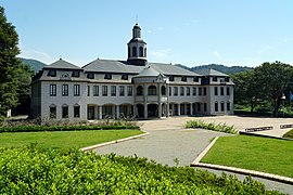
German house Naruto


history
Incorporations
On March 15, 1947 , the district cities ( chō ) Muya ( 撫養 町 , -chō ), Naruto ( 鳴 門 町 , -chō ) and Seto ( 瀬 戸 町 , -chō ), as well as the village ( son ) Satoura ( 里 浦村 ) joined , -son ) in the district of Itano to form the independent city ( shi ) Meinan ( 鳴 南市 , -shi , German "South Naruto"). In May of the same year, the name was changed to Naruto.
In 1955 the village of Ōtsu ( 大 津 村 , -son ), in 1956 the village of Kitanada ( 北 灘村 , -son ) and in 1967 the city of Ōasa ( 大麻 町 , -chō ), each from the district of Itano, was incorporated.
Bandō prisoner of war camp
During the First World War , Bandō - incorporated in 1967 as a district of Ōasa - with the Bandō prisoner of war camp was one of about 12 and later 6 prisoner-of-war camps in Japan, in which Germans were interned who served the Japanese armed forces in the battle for the German colony of Tsingtao ( today Qingdao) were inferior in China. After three camps were merged to form the Bandō camp in April 1917, almost 1,000 German soldiers were temporarily imprisoned there until they were released in 1920.
More than in other camps, the Japanese camp commandant Matsue Toyohisa granted generous personal responsibility outside of morning and evening roll calls. Encounters with the local population and events such as the Japanese premiere of Beethoven's Ninth Symphony on June 1, 1918, resulted in a good and mutually respectful relationship between Germans and Japanese. On the first Sunday in June, the Ode to Joy from Ludwig van Beethoven's 9th Symphony is regularly performed there.
On October 27, 2011, the German President visited the memorial in Naruto.
Town twinning
-
 Germany : Lüneburg, Germany
-
 Japan: Kiryū , Gunma Prefecture (since September 18, 1980)
 -
Japan: Aizu-Wakamatsu , Fukushima Prefecture (since October 30, 1999)
- This is the hometown of the camp commander of the Bandô POW camp, Matsue Toyohisa . Matsue had later served as the mayor of Aizu-Wakamatsu City.
Schools and education
University
The Naruto College of Education is located on Takashima Island . In the bachelor's degree programs, kindergarten teachers, elementary and middle school teachers and special educators are trained on the basis of subject-specific lessons. The Master’s courses, on the other hand, concentrate on individual subject-related aspects.
There is a partnership with the Leuphana University of Lüneburg .
traffic
- Train:
- Street:
- Kobe-Awaji-Naruto Highway
- Takamatsu Highway
- National Road 11 : to Tokushima and Matsuyama
- National Road 28,377
sons and daughters of the town
- Harumi Hiroyama (* 1968), long-distance runner
- Ari Ichihashi (* 1977), long-distance runner
- Yoshiaki Kinoshita (* 1990), soccer player
Neighboring cities and communities
- Tokushima Prefecture
- Kagawa Prefecture
Web links
Independent cities ( shi ): Anan | Awa | Komatsushima | Mima | Miyoshi | Naruto | Tokushima (administrative headquarters) | Yoshinogawa
Itano-gun : Aizumi | Itano | Kamiita | Kitajima | Matsushige | Kaifu-gun : Kaiyō | Minami | Mugi | Katsuura-gun : Kamikatsu | Katsuura | Mima-gun : Tsurugi | Miyoshi-gun : Higashimiyoshi | Myōdō-gun : Sanagouchi | Myōzai-gun : Ishii | Kamiyama | Naka-gun : Naka