Naruto Street
| Naruto Street | ||
|---|---|---|
| Naruto Street satellite image | ||
| Connects waters | Harima-nada, Seto Inland Sea | |
| with water | Kii Canal , Seto Inland Sea | |
| Separates land mass | Shikoku | |
| of land mass | Awaji | |
| Data | ||
| Geographical location | 34 ° 14 '29 " N , 134 ° 39' 4" E | |
|
|
||
| Smallest width | 1.3 km | |
| bridges | Naruto Bridge | |
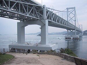
| The Naruto Bridge on the Strait | ||
The Naruto Strait ( Japanese 鳴 門 海峡 , Naruto-kaikyō ) is a strait in Japan with a width of about 1.3 km between Awaji Island and Shikoku Island . It connects Harima-nada , the southeast part of the Seto Inland Sea , with the Kii Channel , which lies between the islands of Shikoku and Honshū and, as the southern part of the Seto Inland Sea, connects them with the Pacific .
The islands of Ōge-jima , Takashima and Shimada-shima are located on Naruto Strait . The waters between these islands are called Uchi-no-umi ( ウ チ ノ 海 , "inner sea") and the southern waterway between these islands and Shikoku is called the "Little Naruto Strait" ( 小 鳴 門 海峡 , Ko-Naruto-kaikyō ) .
The Naruto Strait is famous for the third fastest current in the world (four times a day up to 13-15 km / h, with spring tides even up to 20 km / h) and the resulting Naruto whirlpools with a diameter of up to 20 m . The reason for this is a height difference in the water level between the inland sea and the Pacific of up to 1.5 m due to the tides .
The Naruto Bridge , a suspension bridge with a total length of 1629 m, spans the road with a cantilevered central length of 876 m at a height of 41 m above sea level. It is an important section on the southern part of the Kobe-Awaji-Naruto highway .


