Awaji-shima
| Awaji-shima | |
|---|---|
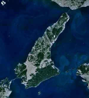
| Landsat recording by Awaji-shima | |
| Waters | Seto Inland Sea |
| Geographical location | 34 ° 23 ′ N , 134 ° 50 ′ E |
| length | 54 km |
| width | 24 km |
| surface | 592.55 km² |
| Highest elevation | Yuzuruha-san 608 m |
| Residents | 128,000 (October 1, 2019) 216 inhabitants / km² |
| main place | Sumoto |
Awaji-shima ( Japanese. 淡 路 島 ) is a 592.55 km² island between the Harima Sea in the west, the Bay of Osaka in the east and the Kii Canal in the south. It belongs to Hyogo Prefecture and is the largest island in the Seto Inland Sea . The Naruto Strait leads southwest into the Harima Sea and the Kitan Strait leads southeast into the Bay of Osaka . In the north it is connected to the Japanese main island of Honshū via the Akashi Kaikyō Bridge , and to the south via the Naruto Bridge to the island of Shikoku .
geography
Awaji-shima is almost continuously hilly with the Yuzuruha-san ( 諭 鶴 羽山 ) as the highest elevation of 608.0 m.
To the south of Awaji-shima lies Nushima , to the southeast on Kitan Street is the Tomogashima Group and to the southwest on Naruto Street Ōge-jima , Takashima and Shimada-shima . In addition, Awaji Island, is surrounded by islets: Narugashima ( 成ヶ島 ; 34 ° 17 '13 " N , 134 ° 57' 12" O ) a sand bench in the Kitan Street, Kemuri-jima ( 煙島 ; 34 ° 14 ' 54 " N , 134 ° 42 '29" O ) and Ozono-Shima ( 大園島 ; 34 ° 14' 32 " N , 134 ° 41 '21" O ) in the Fukura bay in south Okinoshima ( 沖の島 ; 34 ° 15 '27 " N , 134 ° 40' 16" O ) in front of Ibi in the southwest and Benten -shima ( 弁天島 ; 34 ° 17 '30 " N , 134 ° 39' 15" O ) in front of Anaga Shichigawa in the West.
The climate of the island, as in the whole area around the Seto Inland Sea, is relatively mild.
Administrative division
The island is divided into the city districts of Awaji , Sumoto and Minamiawaji . The largest city on the island is Sumoto. As of October 1, 2019, there were about 128,000 inhabitants on the island.
history
Prior to founding the prefecture Hyōgo the island by forming the seventh to the 19th century , the province of Awaji . Awaji means "way to Awa", as Awaji-shima is located between the main island of Honshu and the former province of Awa , today's Tokushima Prefecture . In Kojiki , the island is mythologically referred to as Awaji no ho no sawake no shima ( 淡 道 之 穂 之 狭 別 島 ). In the Edo period , the daimyo of Tokushima , the Hachisuka family, also ruled Awaji from 1615 .
economy
Awaji-shima's economy is largely agricultural. In addition to raising livestock, onions are a typical product. In addition to the road connection to Honshū and a national garden show, extensive infrastructure measures were carried out, which have greatly enhanced the attractiveness of the island.
traffic
There is no railroad on Awaji-shima; Until the opening of the Akashi Kaikyō Bridge in 1998, the island was in the shadow of the nearby agglomerations on Honshū and Shikoku. Thanks to the Honshū-Awaji-Naruto motorway connection as well as extensive road extensions and new developments, the island is now well developed for car traffic and serves as a direct connection between the eastern part of Shikoku and the Kobe-Osaka-Kyoto conurbation . While the Naruto Bridge in the south was designed for road and rail, the Akashi Bridge, which is designed purely for road connections, has to a certain extent cemented the restriction to individual, bus and truck traffic. Passenger and car ferries continue to operate over the Akashi Strait, and there are also ship connections from Sumoto to Kobe and Kansai Airport . Shikoku can only be reached by car or bus from Awaji-shima via the bridge.
Others
The north of the island suffered the greatest damage in the Hanshin earthquake in 1995, along with Kobe. A vivid earthquake museum was set up on the fault line of the Noshima trench running through Hokutan-chō .
Between Awaji-shima and Shikoku is the Naruto whirlpool , a popular tourist destination. The puppet show Ningyō Jōruri is also famous on Awaji-shima .
The famous Japanese architect Tadao Ando built the water temple Hompuku-ji on Awaji-shima.
Web links
Individual evidence
- ↑ 島 面積 . (PDF; 136 kB) (No longer available online.) Kokudo Chiriin , October 1, 2015, archived from the original on June 15, 2016 ; Retrieved July 31, 2016 (Japanese). Info: The archive link was inserted automatically and has not yet been checked. Please check the original and archive link according to the instructions and then remove this notice.

