Isla Capitán Aracena
| Isla Capitán Aracena | ||
|---|---|---|
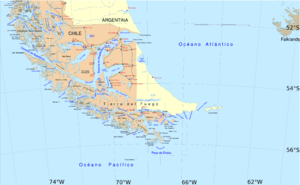
| The south of Patagonia and the archipelago separated by the Strait of Magellan | ||
| Waters | Strait of Magellan | |
| Geographical location | 54 ° 10 ′ S , 71 ° 20 ′ W | |
|
|
||
| length | 140 km | |
| surface | 1.164 km² | |
| Highest elevation | 1158 m | |
| Residents | uninhabited | |
The Isla Capitán Aracena (short Isla Cap Aracena or Isla Aracena ) is an island in the south of Chile . The island forms part of the south coast of the Strait of Magellan . It is the fourth from the west, from the Pacific Ocean , from the east from the Atlantic Ocean , the third one of the islands that form the strait opposite Patagonia . The Canal Cockburn and Canal Magdalena separate the island from Tierra del Fuego to the south and south-east, respectively . The coastline is strongly indented by fjords .
The uninhabited island, like neighboring islands, belongs to the urban area of Punta Arenas .

