Isla del Perejil
| Isla del Perejil | ||
|---|---|---|
| Waters | Strait of Gibraltar | |
| Geographical location | 35 ° 54 '49 " N , 5 ° 25' 9" W | |
|
|
||
| length | 400 m | |
| width | 400 m | |
| surface | 15 ha | |
| Highest elevation | 74 m | |
| Residents | uninhabited | |
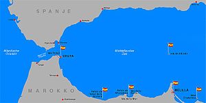
| Map of Ceuta and Isla Perejil (to the west) | ||
The Isla del Perejil (French: Îlot Persil ; German: Petersilieninsel ; Arabic جزيرة تورة, DMG Ǧazīrat Tūra orليلى Lailā 'night') is a small rocky island in the Strait of Gibraltar , which belongs to Spain. It is of strategic importance because of its location.
geography
The Isla de Perejil is 200 meters off the Moroccan coast at Jbel Musa and is about eight kilometers west of the Spanish exclave Ceuta ; it is 400 meters long and also about 400 meters wide. The highest point is 74 meters above sea level. There are scant remnants of old buildings; however, the island has been uninhabited for a long time.
history
After the conquest of Ceuta by Portugal in 1415, Perejil was initially Portuguese territory. Since the personal union of Portugal with Spain (1580) and also after their dissolution (1640), Perejil and the neighboring Ceuta belong to Spain; this status quo was fixed accordingly in the Treaty of Lisbon (1668). Multiple military demands in the past to develop Perejil into a military base were repeatedly rejected for reasons of cost.
Ownership claims
The island is claimed by Morocco. It is not mentioned in the independence treaty with Morocco; hence their affiliation seems doubtful. The majority of the Spanish population was not aware of this problem until on July 11, 2002, Moroccan soldiers occupied the island in order to - as it was reported - from here to be able to observe the illegal drug smuggling. This sparked a diplomatic dispute because both states claimed the island. Spain sent the guided missile frigates Navarra and Numancia to Ceuta to reinforce the Spanish claims to possession , which arrived there on July 15, 2002. On July 18, 2002, Spanish ground forces, as well as naval and air units, brought the Moroccan soldiers off the island. These offered no resistance; then the Moroccan flag was exchanged for a Spanish one. The action became known as the Parsley War after the name of the island .
After international mediation efforts, the two states agreed to reintroduce the status quo that existed before July 11, 2002 .
This case is more problematic than it initially looks, as Morocco also lays claim to the Spanish exclaves of Ceuta and Melilla . As they are in a similar situation to Perejil, the loss of one of its islands (albeit apparently insignificant) would set a serious precedent for the Spanish government.


