
Jbel Musa
| Jbel Musa | ||
|---|---|---|
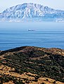
 View over Tarifa (Spain) and the Strait of Gibraltar to Morocco with the striking Jbel Musa |
||
| height | 851 m | |
| location | Morocco , North Africa | |
| Coordinates | 35 ° 53 '52 " N , 5 ° 24' 39" W | |
|
||
| particularities | is considered the southern pillar of Heracles | |


The Jbel Musa or Jbel Moussa , ( Arabic جبل موسى, DMG Ǧabal Mūsā ‚Mosesberg '; tamazight ⴰⴷⵔⴰⵔ ⵎⵓⵙⴰ Adrar Musa), named - according to the Berber traveler Ibn Battuta - after Musa ibn Nusair , the Arab conqueror of the Maghreb and governor of Ifriqiya , is an approximately 851 m high mountain range in northern Morocco and lies on the Strait of Gibraltar .
Geographical location
The Jbel Musa belongs to the western part of the Rif Mountains and is located in the prefecture of M'Diq-Fnideq around eight kilometers west of the Spanish exclave Ceuta . The north face of the mountain range facing the Strait of Gibraltar runs in the promontory called Ras Leona or Ras Lmestoui and forms the Moroccan North Cape , so to speak .
To the southwest of the cape, the Jbel Musa on the coast is preceded by the small rock island Isla del Perejil , which is Spanish territory according to the status quo .
Ascent
Several footpaths run through the limestone mountains, which are largely devoid of vegetation, despite rainfall of around 700 mm / year. A road leads serpentine-like from the small coastal town of Belyounech in the northeast on the northern slope of the mountain to an altitude of about 600 meters and thus close to the summit region.
Pillars of Heracles
Together with the opposite Rock of Gibraltar , the Jbel Musa is often referred to as one of the pillars of Heracles or pillars of Melkart ; This status is also claimed by Monte Hacho, about 10 km to the east on the area of the Ceuta peninsula . In ancient times, the mountain range of Jbel Musa Septem Fratres ("Seven Brothers") was called.
photos

Strait of Gibraltar
Jbel Moussa


See also
Web links
Individual evidence
- ↑ HT Norris: Ibn Battutah's Andalusian Journey . In: The Geographical Journal . 1959.
- ↑ The available altitude information varies between 830 and 851 m.
- ↑ Ras Leona at Geonames
- ↑ Belyounech climate diagrams