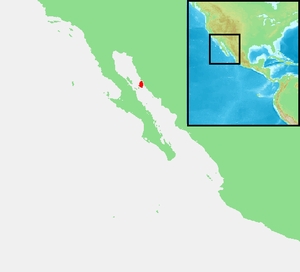
Isla Tiburón
| Tiburón | |
|---|---|
| Tiburón seen from the mainland | |
| Waters | Gulf of California |
| Geographical location | 28 ° 58 ′ N , 112 ° 22 ′ W |
| length | 52.8 km |
| width | 30.7 km |
| surface | 1 200.93 km² |
| Highest elevation | Cerro San Miguel 1450 m |
| Residents | uninhabited |
| main place | (Tecomate) |
| Satellite image (Tiburón in the east) | |
The Isla Tiburón , also Isla del Tiburón ( Seri : Tahéjöc), is the largest island in the Gulf of California and the largest island in Mexico (see the list of Mexican islands ) with an area of almost 1201 km² . The island belongs to the state of Sonora and is about at the level of Hermosillo , Sonora .
In 1957 the island and the Seri Indians living there were visited by the German couple Marianne and Herbert Rittlinger . Today Tiburón is uninhabited and has been a nature reserve since 1963 ( Tiburón means shark in Spanish ).
The earlier or temporary Seri settlement Tecomate is located in the north of the island near a freshwater spring called Pozo Hardy .
Individual evidence
- ↑ Thomas G. Bowen: Seri prehistory: the archeology of the central coast of Sonora, Mexico , issue 27 of the Anthropological papers of the University of Arizona, Verlag University of Arizona Press, 1976, ISBN 0-8165-0358-3 , p. 34.
literature
- Herbert Rittlinger: Land of the Lacandons, Wiesbaden, FA Brockhaus 1959.
Web links
Commons : Isla Tiburón - Collection of images, videos and audio files


