
Ives Trail
| Ives Trail & Greenway | |
|---|---|
 Gate at the start of the Ives Trail ( Danbury ) |
|
| Data | |
| length | 32 km |
| location | Ridgefield, Danbury, Bethel and Redding Connecticut |
| Starting point | Bennett's Pond State Park 41 ° 19 ′ 43.9 " N , 73 ° 28 ′ 51.1" W. |
| Target point | Ives Home on Mountainville Road in Danbury, Connecticut 41 ° 22 ′ 53.4 " N , 73 ° 26 ′ 41.6" W. |
| Type | Themed hiking trail |
| Level of difficulty | easy - medium |
| Viewpoints | Tarrywile Park, Hearthstone Castle |
| particularities | Deer tick , climbing poison sumac |
The Ives Trail and Greenway is a hiking trail in the Housatonic Valley Region ( Greater Danbury ). Over a length of 32 km it connects Ridgefield , Danbury , Bethel and Redding on its route . The Ives Trail is named after Charles Ives , an American modernist composer from Danbury.
The Ives Trail is largely maintained by the Ives Trail and Regional Greenway Association .
Directions
The Ives Trail runs through public and private estates. It runs entirely on the New Milford area, the south end is in the Candlewood Mountain area , the north end is in the Gaylordsville area . The trail is intended for hiking, backpacking, and picnicking, while cycling and horse riding are also possible on individual sections.
history
The Ives Trail was created by the urban planner Dennis Elpern.
Picture gallery

View from Moses Mountain

The Ives House, which gives the trail its name
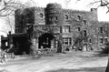
Hearthstone Castle

The main route is marked by red and yellow signs

Alternative routes can be recognized by white signs with a yellow border


Web links
- Homepage of the Ives Trail. Accessed December 1, 2019 .