
Iwase Senzuka Kofu group
Coordinates: 34 ° 13 '25 " N , 135 ° 13' 48.4" E

Iwase Senzuka kofungun group ( Japanese 岩 橋 千 塚 古墳 群 , Iwase Senzuka kofungun ) is an important archaeological site in Japan . It is a group of barrows ( Kofun ) from the Kofun and Asuka periods , which is located in Wakayama in Wakayama Prefecture . The Kofu group was declared a special historical site on March 29, 1952 . There are a total of 27 groups with 680 to 850 barrows on an area of 61,000 m², which date to the period from the 5th to the 7th century.
overview
The Kofu group is associated with a group of ruling families, the Kii no kuni no miyatsuko ( 紀伊国 造 ). They ruled in the province of Kii , today the prefecture of Wakayama, mostly small areas ( kuni ) with not precisely defined borders. The barrows are spread north to Narukami, referred to as Hanayama, and south to Okazaki, referred to as Inbe Hachiman-yama Kofun. To the west the archaeological area extends to Miya, where the Kii Kuni no miyatsuko are entrenched in the Hinokuma and Kunikakasu shrine complex . The round kofun ( 円 墳 , empun ) make up the majority of the barrows , kofun with keyhole shape ( 前方 後 円 墳 , zempō kōenfun ), however, only 1% and kofun with a rectangular base ( 方 墳 , hōfun ) the rest of the barrows . It is believed that the barrows were built from the 2nd half of the 6th century
Digs
- In 1906 Shōgorō Tsuboi made the first exploration
- In 1907, Ōno Ungai (1863–1938) began excavating and introduced the experts to the construction method of stone chambers with a side entrance ( 横 穴 式 石室 ).
- 1918 excavations by Katsumi Kuruita, Taketoshi Iwai and Kingo Tazawa
- 1931 Part of the main group is declared a regional historical site; In 1952, in accordance with the Cultural Property Protection Act, it was designated a special historical site; between 1988 and 2000 more barrows were added to the declaration.
- 1980 Project for the precise mapping of the barrow distribution.
The 65 hectare site is currently being run, maintained and made accessible to the public as an open-air museum . Information is available from the Kii-fudoki no oka Museum in Wakayama Prefecture.
Important kofun
Maeyama Kofun
- Shogun-zuka Kofun (B53): Keyhole Kofun with a height of 42.5 m, a ceiling height of 4.3 m and a side entrance. Unearthed material goods: silver bracelets, iron goods, Haji and Sue ceramics , precious stones and horse harness. The stone chamber is open to the public.
- Chiji-zuka Kofun (B67): Keyhole Kofun with a height of 34.5 m and a diameter of 16.2 m. Unearthed material goods: Haniwa and Sue pottery
- Gunchō-zuka Kofun (B112): Keyhole Kofun with a height of 30.5 m.
- Tennō-zuka Kofun: with a height of 88 m, the largest keyhole kofun in the prefecture. The stone burial chamber with a side entrance is the second largest in Japan with a height of 5.9 m from floor to ceiling.
- Maeyama Kofun A47: with a diameter of 27 m and a height of 8 m, the largest round kofun among the Maeyama barrows. The stone chamber is open to the public.
Dainichiyama Kofun
- Dainichiyama Kofun 35: Keyhole Kofun with a height of 86 m. Unearthed material goods: Haniwa in cylinder and house shape, as well as some finds unique in the country, including a Haniwa in the shape of a bird spreading its wings, Haniwa with two faces, on the front and back ( 両 面 人物 埴 輪 ) and Haniwa in the shape of Hip quivers ( 胡 籙 埴 輪 , Koroku haniwa ).
gallery

Maeyama Kofun A13 corridor from the entrance to the burial chamber

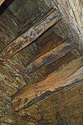
Maeyama Kofun A46 burial chamber

Maeyama Kofun A56 entrance area to the stone chamber

Maeyama Kofun A100 stone coffin made from stone slabs

Maeyama Kofun A111 Shaft-like stone chamber

Maeyama Kofun B53, the Shogun-zuka Kofun ( 将軍 塚 古墳 )

Maeyama Kofun B53, stone chamber of the Shogun-tsuka Kofun

Maeyama Kofun B67, the Chiji-zuka Kofun ( 知事 塚 古墳 )

Maeyama Kofun B112, the Gunchō-zuka Kofun ( 郡 長 塚 古墳 )
Stone chamber of Tennō-zuka Kofun

Hanayama Kofun 6 hills

Hanayama Kofun 6 stone chamber

Inbe Maeyama Kofun B10, the Inbe hachiman-yama Kofun ( 井 辺 八 幡 山 古墳 )


,_funkyu-2.jpg)
,_genshitsu-1.jpg)


,_genshitsu-2.jpg)


Web links
- 岩 橋 千 塚 古墳 群 . In:Cultural Heritage Online. Cultural Affairs Office,accessed August 27, 2019(Japanese).
- 岩 橋 千 塚 古墳 の 紹 介 . Wakayama Prefecture Kii-fudoki-no-oka Museum of Archeology and Folklore,accessed August 27, 2019(Japanese).
Individual evidence
- ↑ 岩 橋 千 塚 古墳 群 . In: The cultural properties of Wakayama City. 和 歌 山 市 文化 振興 課 , 2009, accessed August 27, 2019 (Japanese).
- ↑ a b 岩 橋 千 塚 古墳 群 . In: デ ジ タ ル 版 日本人 名 大 辞典 + Plus at kotobank.jp. Retrieved August 27, 2019 (Japanese, the number of barrows varies.).
- ↑ 将軍 塚 古墳 (前 山 B53 号 墳) . In: kofun map. 2019, Retrieved August 27, 2019 (Japanese).
- ↑ 知事 塚 古墳 (前 山 B67 号 墳) . In: kofun map. 2019, Retrieved August 27, 2019 (Japanese).
- ↑ 郡 長 塚 古墳 (前 山 B112 号 墳) . In: kofun map. 2019, Retrieved August 27, 2019 (Japanese).
- ↑ 大 日 山 35 号 墳 . In: kofun map. 2019, Retrieved August 27, 2019 (Japanese).