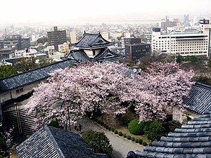
Wakayama
| Wakayama-shi 和 歌 山 市 |
||
|---|---|---|
| Geographical location in Japan | ||
|
|
||
| Region : | Kinki | |
| Prefecture : | Wakayama | |
| Coordinates : | 34 ° 14 ' N , 135 ° 10' E | |
| Basic data | ||
| Surface: | 210.23 km² | |
| Residents : | 355,825 (October 1, 2019) |
|
| Population density : | 1693 inhabitants per km² | |
| Community key : | 30201-5 | |
| Symbols | ||
| Flag / coat of arms: | ||
| Tree : | Camphor tree | |
| Flower : | azalea | |
| town hall | ||
| Address : |
Wakayama City Hall 23 Shichiban-chō Wakayama -shi Wakayama 640-8511 |
|
| Website URL: | http://www.city.wakayama.wakayama.jp/ | |
| Location of Wakayamas in Wakayama Prefecture | ||
Wakayama ( Japanese 和 歌 山 市 , - shi ) is a city and the administrative seat of Wakayama Prefecture on the Japanese main island of Honshū .
Wakayama has a university and medical college. In addition to mechanical engineering , there is cotton, leather and pharmaceutical industries here. The city has 355,825 inhabitants (October 1, 2019).
history
After Toyotomi Hideyoshi had defeated the monks of Negoro-ji , he gave the province of Kii to his brother Toyotomi Hidenaga (豊 臣 秀 長; 1540–1591). He built a castle there and gave it to Kuwayama Shigeharu (桑 山 重 晴, 1586–1596). In 1600, Tokugawa Ieyasu Asano Yukinaga (浅 野 幸 長; 1576–1613) established there until 1619, Ieyasu's 10th son, Tokugawa Yorinobu (徳 川 頼 宣; 1602–1671), took over the province and built a new castle there. The descendants formed one of the "three honorable families" ( Gosanke ), who then ruled there until the Meiji Restoration .
In 1713 the 5th Prince Tokugawa Yoshimune founded a Han school , which was initially called Kōyakujo (講 訳 所), from 1716 then Kōdō (講堂). There taught u. a. Itō Jinsai and Kinoshita Jun'an , under whom Gion Nankai studied. It was the most famous Han school in the country until it fell into decline. In 1790, the 10th Prince Tokugawa Harutomi (徳 川 治 宝; 1771-1853) rebuilt the school and had a hall consecrated to Confucius under the common name of "Seidō" (聖堂) built. The following year the school was given its final name Gakushūkan (学習 館). In 1866 it was moved to the Okayama district south of the castle. Today the Wakayama University's elementary and middle school is located there .
geography
Wakayama is located on the Kii Canal at the mouth of the Kinokawa River . At the northern end of the channel between the island of Awaji in the Kitan Strait are the four islands of Tomogashima .
Attractions
- Wakayama Castle ( 和 歌 山城 Wakayama-jō )
- Wakayama Prefecture Museum ( 和 歌 山 県 立 博物館 Wakayama-kenritsu hakubutsukan )
- Prefecture Museum of Modern Art ( 和 歌 山 県 立 近代 美術館 Wakayama-kenritsu kindai bijutsukan )
- Yōsui Park ( 養 翠園 Yōsui-en )
- The Kimii-dera ( 紀 三井 寺 ), a temple on the Saigoku pilgrimage route
Town twinning
-
 Bakersfield , California , USA (since 1961)
 -
 Richmond , British Columbia , Canada (since 1973)
 -
 Jinan , People's Republic of China (since 1983)
 -
 Jeju , South Korea (since 1987)
Personalities
- Shinkei (1406–1475), Buddhist clergyman and poet
- Yoshimune Tokugawa (1684-1751), 8th Shogun
- Sawako Ariyoshi (1931–1984), writer
- Nobuaki Kobayashi (1942–2019), multiple billiards world champion
- Shōko Sugitani (* 1943), pianist
- Hyde (born 1969), singer
- Katsuyuki Konishi (* 1973), voice actor
- Masato Tanaka (born 1973), wrestler
- Nami Tamaki (* 1988), singer
- Yoshito Matsushita (* 1989), soccer player
- Jun Kamita (* 1992), soccer player
traffic
- train
- Street:
- Hanwa Highway
- National road 24, 26, 42
Neighboring cities and communities
Individual evidence
- ↑ 姉妹 都市 ・ 友好 都市. Wakayama City Sister City Relationships. Retrieved August 20, 2016 (Japanese).
literature
- Wakayama-ken kotogakko-shakai-ka kenkyu-kyokai (Ed.): Wakayama . In: Wakayama-ken no rekishi sampo. Yamakawa Shuppan, 2009. ISBN 978-4-634-24630-0 . P. 229.
- Papinot, Edmond: Wakayama . In: Historical and Geographical Dictionary of Japan. Reprinted by Tuttle, 1972 edition of 1910 edition. ISBN 0-8048-0996-8 .
Web links
- Official website of the city
- Wakayama City Tourist Association - English
- Waiker's Guide Map to Wakayama ( Memento from August 18, 2013 in the Internet Archive ) - English


