Jacques Cousteau Island
|
Isla Jacques Cousteau Isla Cerralvo Jacques Cousteau Island Cerralvo Island |
||
|---|---|---|
| Gulf of California island map | ||
| Waters | Gulf of California | |
| Geographical location | 24 ° 14 ′ N , 109 ° 53 ′ W | |
|
|
||
| length | 29.5 km | |
| width | 7.2 km | |
| surface | 136.5 km² | |
| Highest elevation | 771 m | |
| Residents | uninhabited | |
| Map section | ||
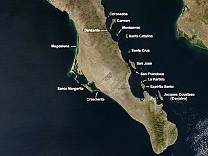
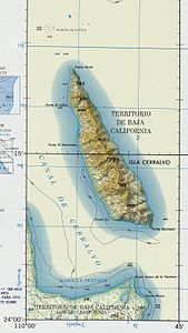
The Isla Cerralvo (Mexican- Spanish pronunciation : [Izla seralbo] ), officially Isla Jacques Cousteau ( [Izla ʝak Kusto] ), is the southernmost of the Mexican islands in the Gulf of California .
The island was renamed in honor of the French marine researcher Jacques-Yves Cousteau , to whom Mexico owes its first marine research station in Baja California , in November 2009 against some protests in the country. The Isla Cerralvo is 136.5 km² in size, 29.5 km long and up to 7.2 km wide in north-south direction, and is 11.7 km off the coast near the city belonging to the state of Baja California Sur La Paz in the municipality of La Paz . In between is the Canal de Cerralvo . The island is volcanic and reaches a height of 771 meters. At the southeast end of the island, Punta Montaña , there is an 11 meter high lighthouse .
Since 2005, the island has been a UNESCO World Heritage Site along with 243 others in the Gulf of California . A number of endemic species live on it, e. B. the iguana Ctenosaura hemilopha insulana , the lizards Sceloporus grandaevus and Cnemidophorus ceralbensis and the snake Rhinocheilus etheridgei . Whales frequently migrate through the Cerralvo Channel .
Web links
Individual evidence
- ↑ http://www.lefigaro.fr/flash-actu/2009/11/17/01011-20091117FILWWW00603-une-ile-cousteau-au-mexique.php
- ↑ Sailing Directions (enroute), Pub. 153 (PDF; 3.3 MB)
- ↑ Iles et aires protégées du Golfe de Californie
- ↑ Amphibians and reptile of Baja California by Lee Grismer, University of California Press , 2002, p 211


