Juglot
| Juglot | ||
| State : |
|
|
| Province : | Gilgit-Baltistan | |
| Coordinates : |
35 ° 55 ' N , 74 ° 20' E
|
|
| Residents : | 27,000 | |
| Time zone : |
PST ( UTC + 5 )
|
|
|
|
||
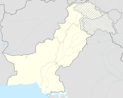
Juglot or Jaglot is a city in the Gilgit District in the Autonomous Territory of Gilgit-Baltistan , the former northern areas of Pakistan . Juglot is located about 45 kilometers southeast of Gilgit on the Karakoram Highway .
Meaning and location
Juglot is an economically important city in the territory. In addition to Gilgit, Juglot has economic relationships with the other six districts (Skardu, Ghanche, Ghizar, Hunza-Nagar, Diamir and Astore districts) of the autonomous region of Gilgit-Baltistan. The city has the largest depots for oil, wheat and flour in the region. The place and the surrounding villages have about 27,000 inhabitants with 3,000 houses. 33 percent of the population have an education, which is significantly higher than the average in northern Pakistan.
Villages
Juglot includes 15 villages: The village Damote has meaning for its summer pastures for livestock in Chakarkot and Pahote is the intersection of three important mountain ranges, the Karakoram , Himalayas and Hindukush . Chakarkot is also named Sabil, Shumrote and Jagot.
Residents
The local population consists of about 30 percent Shin , including the Koliwalshin (Gabare and Chillisso) and about 23 percent Yashkun , while the rest of the population is made up of smaller tribes. The people who came from Kashmir live in the center of the village. Minorities in Juglot are the Karamin , Marotche and Pashtuns .
