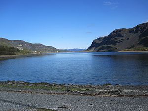
Kåfjord (Finnmark)
| Kåfjord | ||
|---|---|---|
|
The Kåfjord. The church in the village of Kåfjord can be seen on the left at the edge of the picture |
||
| Waters | Altafjord | |
| Land mass | Scandinavian peninsula | |
| Geographical location | 69 ° 56 '11 " N , 23 ° 3' 10" E | |
|
|
||
| width | approx. 1 km | |
| length | approx. 7 km | |
The Kåfjord is a branch of the Altafjord in the province of Troms og Finnmark in Northern Norway. It is located at the southwest end of the Altafjord and is about 7 km long and 1 km wide. In the fjord is the village of Kåfjorden ( Alta ) and the historic Kåfjord Church ( Norwegian : Kåfjord kirke).
The European route 6 runs along the northern coastline , whose route around the fjord has been shortened since 2013 by a new bridge followed by a 1.1 km long tunnel to Kvenvik .
history
Copper ore was mined at Kåfjord from 1826 to 1909 . The mine was the first major industrial venture in Northern Norway. Today only ruins remain of the former facilities, which can be viewed from a 1.2 km long nature trail. At the time of copper mining, around 1,000 people settled on the banks of the Kåfjord in a village of the same name. The village was almost completely destroyed during World War II. The village church built in 1837 in the English style has been preserved. Today the village of Kåfjord is administratively part of the city of Alta, but is located about 20 km west of the actual city area. The village is only inhabited by a few dozen people.
From 1899 to 1926, the 904 m high mountain Haldde by the Kåfjord was home to the world's first observatory for observing the northern lights . The observatory, which largely fell into disrepair in the following years, is now partially renovated. It can be reached via a 9 km path from Kåfjord and is open to the public.
During the Second World War, the Kåfjord served as an anchorage for the German battleship Tirpitz in 1943 and 1944 and the fjord was therefore repeatedly the scene between British aircraft and the German air defense. In 1944, among other things, Operation Tungsten and Operation Mascot took place here, in which British carrier aircraft attacked the Tirpitz . Ultimately, the ship was capsized near Tromsø by British bombers in November 1944 . Today, the privately operated Tirpitz Museum is located on the Kåfjord , where objects from the ship are exhibited.
See also
Web links
- Website Alta (no / en)
- Alta Museum (no / en)
- Tirpitz Museum (no / en / de)
Individual evidence
- ↑ Store norske leksikon : Kåfjorden i Alta ( Norwegian ). Retrieved January 16, 2013.
- ↑ E6 Møllnes-Kvenvik (Parsell 6, Alta vest) ( Norwegian ) Statens Vegvesen. Archived from the original on January 29, 2013. Retrieved January 16, 2013.

