
Kaiserstrasse (Saarbrücken)
| Kaiserstrasse | |
|---|---|
|
|
|
 |
|
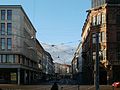
| View of Kaiserstraße in the upper part with Saarbahn stop (2019) | |
| Basic data | |
| place | Saarbrücken |
| District | St. Johann |
| Hist. Names | Rathausstrasse |
| Connecting roads | Großherzog-Friedrich-Strasse, St. Johanner Strasse |
| Cross streets | Futterstraße, Sulzbachstraße, Passestraße, Karcherstraße |
| Technical specifications | |
| Street length | 450 m |
The Kaiser Street is a 450-meter-long street in Saarbrücken district St. Johann .
Location and course
Kaiserstraße is the extension of Großherzog-Friedrich-Straße and begins at the intersection with Dudweilerstraße at the Johanneskirche . In the course of the road, the Futterstraße (after 120 meters from the left), the Sulzbachstraße (junction after 170 meters), the Passestraße (after 260 meters from the left) and the Karcherstraße (after 260 meters from the right) join and cross. At the intersection with Viktoriastraße and the confluence with Ursulinenstraße, after about 450 meters from the right, Kaiserstraße turns into St. Johanner Straße. Kaiserstraße is a one-way street and forms part of federal highway 51 .
history
Kaiserstraße was created around 1852 as an alternative route to Saarbrücken central station. It was parallel to the Bahnhofstrasse , but for a long time had only a minor traffic significance, since most of the cars, the trams , the trolleybuses and the bus lines of the company for trams in the Saartal used the Bahnhofstrasse. Since 1980, however, the Kaiserstraße has been booming. Around 1990 Bahnhofstrasse became a pedestrian zone, with which all car and bus traffic (trams and trolleybuses were shut down at that time) were directed to Kaiserstrasse. Since 1997 the Saarbahn has also taken the S1 line to Kaiserstrasse. There is also a stop with the name there.
Surname
The street was named as an expression of pride for the first German Emperor Wilhelm I (1797–1888). Kaiserstraße was named “Rathausstraße” twice: between the end of the First World War (around 1919) and 1926 and between the end of the Second World War (around 1945) and the annexation of the Saarland to the Federal Republic (around 1956).
Buildings
The Kaiserstraße, like the parallel Bahnhofstraße, is characterized by its arcades , which were created after the Second World War according to the plans of the architect and city planner Georges-Henri Pingusson . The city's former synagogue was located on the corner of Futterstrasse and Kaiserstrasse between 1888 and its destruction during the Reichspogromnacht in 1938. The Hotel Messmer on the corner of Kaiserstraße and Viktoriastraße has been one of the leading hotels in the city since the 1880s. It was demolished in the early 1960s and replaced with the C&A building. Today there are three architectural monuments on Kaiserstraße (house numbers 26a, 26b, 28).

View from the Futterstraße junction towards Johanneskirche (2003)

DocMorris -Filiale (2007), which led to a legal dispute before the ECJ
Lower part of Kaiserstraße seen from Johanneskirche (2012)

Arcades with a view of the intersection of Karcher- and Passestrasse (2015)


Web links
Individual evidence
- ↑ a b Markus Philipp: Encyclopedia Saarbrücken street names. Geistkirch, Saarbrücken 2019, ISBN 978-3-946036-91-3 , p. 238.
- ^ Rainer Freyer: Street names in Saarland: Several waves of street renaming between 1920 and 1960. In: saar-nostalgie.de (August 20, 2020).
- ^ Hans-Christian Herrmann: Saarbrücken 1945–74: Urban development between tradition and modernity. In: Rolf Wittenbrock (ed.): History of the city of Saarbrücken. Volume 2: From the time of rapid growth to the present. SDV, Saarbrücken 1999, ISBN 3-930843-41-2 , p. 415.
- ↑ From luxury hotel to department store - and back? In: sr.de (January 26, 2020).
- ^ Partial list of monuments in the St. Johann district. In: saarbruecken.de (February 16, 2011).
Coordinates: 49 ° 14 ′ 14.5 ″ N , 6 ° 59 ′ 40.5 ″ E