Cameroon estuary
| Cameroon estuary Wouri estuary |
|
|---|---|
|
The Wouri estuary lagoon with Mont Cameroun in the northwest. |
|
| Waters | Bonny Bay |
| Land mass | Central Africa |
| Geographical location | 3 ° 55 ' N , 9 ° 34' E |
| width | approx. 25 km |
| depth | approx. 25 km |
| Greatest water depth | over 20 |
| Medium water depth | 5 m |
| Tributaries | Wouri , Mungo , Dibamba , Kwa Kwa |
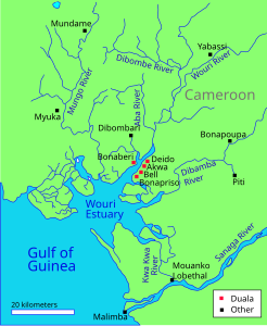
Cameroon estuary (English Wouri estuary, also Cameroon estuary ) refers to an estuary in Cameroon .
location
It is the mouth of the Wouri which, together with several tributaries at Douala , turns into a "six-lobed bay". It is located in the region of the Bay of Biafra, which has been called the Bay of Bonny since 1970 . The term is used in contemporary literature on German protected areas in Africa.
Protected areas
The east side of the estuary is bounded by the Douala-Edea Wildlife Reserve and the southeast by the Mouanko reserve . The Wuri estuary is known for its extensive mangrove forests and marshland.
history
The Wouri estuary lagoon played an important role in the colonization of Cameroon. It represents a protected natural harbor and was the gateway to the interior.
Individual evidence
- ^ Deutsches Kolonial-Lexikon (1920), Volume II, p. 219 online preview (accessed on December 29, 2011)

