
Douala
| Douala | |||
|---|---|---|---|
|
|||
| Coordinates | 4 ° 3 ' N , 9 ° 43' E | ||
| Basic data | |||
| Country | Cameroon | ||
| Littoral | |||
| ISO 3166-2 | CM-LT | ||
| height | 13 m | ||
| surface | 210 km² | ||
| Residents | 2,768,436 (2015) | ||
| density | 13,183 Ew. / km² | ||
| Website | douala.cm ( French ) | ||


Douala , in German Duala , is the largest city in Cameroon with around 2.768 million inhabitants (2015) . It is named after the Duala people . As an economic metropolis, the former capital (until 1920; since then Yaoundé ) is the financial, industrial, commercial and cultural center as well as the transport hub of the Central African state. Douala is the capital of the Littoral region and the capital of the Wouri administrative district .
geography
Geographical location
The city is located 24 kilometers from the Atlantic coast on the banks of the Wouri River, an average of 13 meters above sea level .
The most important and largest port in Cameroon was built on the river delta . Most of the city lies on the left bank of the Wouri River. The geographic coordinates are 4.05 degrees north and 9.7 degrees east. The Douala-Edea Game Reserve is south of the city.
climate
Douala is located in the tropical climate zone . The average annual temperature is 26.2 degrees Celsius, the annual rainfall is 3847 millimeters on average.
Temperatures are between an average of 24.6 and 27.6 degrees Celsius all year round. During the rainy season from June to October there is a lot of precipitation, with August being the rainiest month with an average of 768 millimeters. It stays drier between November and March.
| Douala | ||||||||||||||||||||||||||||||||||||||||||||||||
|---|---|---|---|---|---|---|---|---|---|---|---|---|---|---|---|---|---|---|---|---|---|---|---|---|---|---|---|---|---|---|---|---|---|---|---|---|---|---|---|---|---|---|---|---|---|---|---|---|
| Climate diagram | ||||||||||||||||||||||||||||||||||||||||||||||||
| ||||||||||||||||||||||||||||||||||||||||||||||||
|
Average monthly temperatures and rainfall for Douala
Source: wetterkontor.de
|
|||||||||||||||||||||||||||||||||||||||||||||||||||||||||||||||||||||||||||||||||||||||||||||||||||||||||||||||||||||||||||||||||||||||||||||||||||||||||||||||||||||
history


The area of today's city was originally a swamp area . At the beginning of the 18th century the area was settled by the people of the Douala, a section of the Cameroonian coastal Bantu , who immigrated from the north . Among them, several initially independent fishing settlements (including Bonaberi, Bonanjo, Bonaku, Bonabela, Akwatown, Belltown) emerged as the historical centers of the current urban area, and were inhabited by different clans. In contact with Europeans, the delta of the Cameroon River (which was also known as the Cameroon estuary ) developed into a strategically important point for the slave trade , especially with Portuguese traders, by the middle of the 19th century .
,_Kamerun,_Dezember_1884.jpg)
From around 1860, palm oil was the main commodity in trade between the Douala and the Europeans. The trade was soon dominated by the Hamburg trading houses Woermann and Jantzen & Thormählen , who had tried to declare German patronage over the coast since the 1880s to protect their interests, especially against British competition. On July 12, 1884, the doctor and research traveler Gustav Nachtigal (1834–1885) , who was sent to the West African coast by the Foreign Office as Reich Commissioner, signed a "protection treaty" with the Douala chiefs Ngand'a Kwa (Akwa) and Ndumb on behalf of the German Empire 'a Lobe ( Bell ) and placed the country under German protectorate . The place was named Kamerunstadt (from 1902: Duala ) and was the administrative seat of the German protected area from 1885 to 1901 . Since 1895 there was an independent district office in Duala, whose area of responsibility extended far beyond the city's soft landscape into the hinterland on both sides of the Abo and Wuri .
At the instigation of Governor Jesko von Puttkamer , the seat of government was relocated to Buea am Kamerunberg in 1901 because of the healthier climate . However, Duala remained the economic and social center of the colony until the First World War. In addition, as the location of the main company of the Imperial Protection Force , the artillery detachment , the highest civil and military medical authority and the central materials administration, it played an important role in military security. The command of the protection force, initially also based in Duala, was relocated in 1904 to Soppo , located below Buea on the Cameroon Mountain .
In Duala, the most important port of export and the economic center of Cameroon, all the important trading companies operating in Cameroon had branches or factories. The Woermann Line operating at the port of Douala Floating .
During the course of German rule, the local elites and the colonial administration broke out several times over the curtailment of the rights of the local population guaranteed in the protection treaty, which culminated in two petitions to the Reichstag. The attempts of the district office to expropriate the traditional settlement areas on the river in favor of the expanding industry (railway and port facilities) led to open resistance. The Duala chief Rudolf Manga Bell was sentenced to death and executed by a German court in 1914 with his secretary . As a result, the majority of Douala supported the advancing British and French during World War I and welcomed them as liberators.
After initially joint administration, the city came under French rule through the Anglo-French Agreement of 1916.
Population development of the agglomeration according to the UN
| year | population |
|---|---|
| 1950 | 95,000 |
| 1960 | 153,000 |
| 1970 | 298,000 |
| 1980 | 571,000 |
| 1990 | 940,000 |
| 2000 | 1,490,000 |
| 2010 | 2,361,000 |
| 2017 | 3,259,000 |
Economy and Infrastructure
Commercial enterprises
The production of chemical and aluminum products , textiles , beer (e.g. Brasseries du Cameroun , Guinness , Isenbeck ) and non-alcoholic beverages as well as the processing of wood and cocoa beans are the most important branches of production.
The port of Douala- Bonabéri , which can be used for ships up to 16,000 GRT and through which 97% of Cameroon's total cargo handling is handled, is also of great importance . The total area of the port area is around 300 hectares, including the container port, a fishing port and the wooden port. The oil port and the charging stations for bananas and minerals are located in Bonabéri on the western bank of the Cameroon Estuary.
traffic
Most travelers to Cameroon from Europe arrive at Douala International Airport . It is also the base of the national airline Camair-Co .
The city is known as the “crossroads of Africa”, not only because of its role as a maritime and air transport hub, but also because it is a “melting pot” of the country's various ethnic groups who come here to trade.
For domestic traffic, there are bus connections in all directions, including Edéa, Yaoundé, Bafang, Bafoussam and Bamenda. Shared taxis run from Deido to Limbe (Victoria), Tiko and Buea .
The railway line to Yaoundé with a connection to Ngaoundéré ( Transcamerounais ) also begins in Douala . On the 66 km from Douala ↔ Mbanga ↔ Kumba , three local trains ("Omnibus") with wooden bench class run daily.
education
In the city is the Douala University, founded in 1993, with over 40,000 students and 700 teachers (2012/13). It is divided into six faculties . Three universities of applied sciences are affiliated with it.
Sports
There are numerous football clubs in the city:
- Les Astres FC
- Caïman Douala
- Léopards Douala
- Oryx douala
- Union Douala
- Kadji Sports Academy , also a sports boarding school
Les Astres, Caïman and Union play their games in the Stade de la Réunification .
The Stade Omnisport de Douala (or Douala Japoma Stadium, Omnisports stadium of Douala-Japoma or Japoma sports complex) has been a sports facility under construction since 2017 . The complex includes a stadium with 50,000 seats as well as basketball, handball, volleyball and tennis courts, a tartan track, an Olympic-sized swimming pool with eight lanes, conference rooms, commercial centers, a four-star luxury hotel and a parking garage.
military
The battalion blindé de reconnaissance of the Brigade d'intervention is rapidly stationed in Doula .
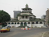
Attractions
- Former German governor's building (interior cannot be visited)
- Bonakuamuang fireplace
- Old German Post Office (Bonanjo)
- Mandessi Bell House (Bonanjo), next to the old post office
- Former German police station (next to the town hall in Bonanjo)
- Palace of Justice (built under the French mandate)
- Former German barracks and French hospital , now Bonanjo Police Building (GMI)
- German seaman's home (Foyer du Marin)
- Residence of Rudolf Manga Bell , called "La Pagode" because of the multi-storey staggered construction
- Municipal museum, on the first floor of the town hall, with ethnographics from all over Cameroon
- Musee de la Marine
- Roman Catholic St. Peter and Paul Cathedral of the Archdiocese of Douala , built in 1936 in neo-Romanesque style
- Temple du Centenaire, Baptist church, built in 1945 to commemorate the centenary of the arrival of the missionary Alfred Saker
- German cemetery
- Stade Akwa sports stadium
- Monument du Roi Akwa, monument to King Akwa (signatory of the 1884 Protection Treaty)
"Pagoda", formerly the royal palace

Temple du Centenaire


Town twinning
Douala has entered into a partnership with the following cities and regions:
|
|
sons and daughters of the town
- Louis Brody (1896–1951), German actor
- Francis Bebey (1929–2001), French musician and writer
- Manu Dibango (1933-2020), musician
- Joseph Bessala (1941-2010), boxer
- Patrick Baudry (* 1946), French astronaut
- Joseph Marie Ndi-Okalla (* 1957), Roman Catholic clergyman, Bishop of Mbalmayo
- Calixthe Beyala (* 1961), French writer
- Étienne M'Bappé (* 1964), fusion and world musician
- Cyrille Makanaky (* 1965), football player
- Petit Pays (born 1966), singer
- Olivier Djappa (* 1969), football player
- Patrick M'Boma (* 1970), football player
- Hemley Boum (* 1973), writer
- Léonora Miano (* 1973), writer
- Didier Angibeaud (* 1974), football player
- Raymond Kalla (* 1975), football player
- Lucien Mettomo (* 1977), French-Cameroonian football player
- Pierre Womé (* 1979), football player
- Jean-Alain Boumsong (* 1979), French football player
- Carlos Takam (* 1980), heavyweight boxer
- Samuel Eto'o (born 1981), football player
- Éric Djemba-Djemba (* 1981), football player
- Habib Gock (* 1982), soccer player
- Thimothée Atouba (* 1982), football player
- Somen Tchoyi (* 1983), football player
- Amadou Dangadji Rabihou (* 1984), Cameroonian-Austrian football player
- Véronique Mang (* 1984), French athlete
- Idriss Carlos Kameni (* 1984), French-Cameroonian football player
- Pierre Boya (* 1984), football player
- Albert Baning (* 1985), football player
- Aurélien Chedjou (* 1985), football player
- Alexandre Song (born 1987), football player
- Alain Junior Ollé Ollé (* 1987), football player
- Perial Ndengue (* 1987), soccer player
- Irma (* 1988), Cameroonian singer and songwriter living in France
- Georges Mandjeck (* 1988), football player
- Gabrielle Aboudi Onguene (* 1989), football player
- Albert Ebossé Bodjongo (1989-2014), football player
- Dominique Wassi (* 1989), soccer player
- Franck Etoundi (* 1990), football player
- Claudine Meffometo (* 1990), soccer player
- François Moubandje (* 1990), Swiss football player
- Yvonne Patrice Leuko Chibosso (* 1991), soccer player
- Madias Nzesso (* 1992), weightlifter
- Dave Sutter (born 1992), ice hockey player
- Paul-Georges Ntep (* 1992), French football player
- Ibrahim Amadou (* 1993), French football player
- Frantz Pangop (* 1993), football player
- Pascal Siakam (* 1994), basketball player in the North American professional league NBA
- Christian Bassogog (* 1995), football player
- Antoinette Guedia (* 1995), swimmer
- Fabrice Olinga (* 1996), football player
- Nelson Mandela Mbouhom (* 1999), football player
- Felix Chenkam (* 1998), football player
literature
- Andreas Eckert : Land ownership, land conflicts and colonial change: Douala 1880 to 1960 . Steiner, Stuttgart 1999, ISBN 978-3-515-06777-5 .
- Regina Fuchs: Cameroon , Bielefeld, 3rd edition 2001.
- Stefanie Fuchs, Albert Pascal Temgoua (ed.): Bilingual in French and English; The Politics of Colonial Memory in Germany and Cameroon. Proceedings of a conference in Yaoundé , October 2003 , LIT Verlag, Münster 2005 ISBN 3-8258-7836-8 .
Web links
proof
- ^ Keyword Duala. In: Heinrich Schnee (Ed.): German Colonial Lexicon. Quelle & Meyer, Leipzig 1920, Volume I, p. 477 ( online ).
- ↑ World Urbanization Prospects - Population Division - United Nations. Retrieved July 23, 2018 .
- ^ Website Douala - Coopération internationale et jumelage , accessed on March 25, 2018