
Yaounde
| Yaoundé Yaoundé |
|||
|---|---|---|---|
|
|||
| coordinates | 3° 52′ N , 11° 31′ E | ||
| basic data | |||
| Country | Cameroon | ||
| Centre | |||
| district | Mfoundi | ||
| ISO 3166-2 | CM-CE | ||
| height | 730 m | ||
| resident | 1,926,496 (2019 estimate) | ||
 |
|||


Yaoundé , officially Yaounde ([ ja.unˈdeː ] in German), is the capital of Cameroon and, with around 2.4 million inhabitants (2017 estimate), the country's second-largest city after the port city of Douala . Yaoundé is also the capital of the Center region . The name Yaoundé is a deformation of the name of the Ewondo , the ethnic group originally based here. Ewondo speakers call Yaoundé Ongola .
geography
Geographical location
The town lies at an altitude of 730 m . The city is built on hills and is articulated on the north-south axis around the river Mfoundi . To the west of the city rise Mont Mbankolo and Mont Fébé (approx. 1000 meters - exact height unknown). Cameroon is most densely populated around the capital Yaoundé. Many of the residents live in the sprawling suburbs. The city is surrounded by tropical jungle.
neighborhoods and orientation
urban districts and districts


Yaoundé is administratively divided into seven districts and has around a hundred districts. The quarters are particularly important as landmarks:
- Barrière - Peripherally located in the extreme south at the entrance to the city on the road to Douala.
- Bastos - Noble residential area in the north-west of Yaoundé and seat of most embassies, consulates and foreign NGOs. It also contains the palatial home of Bernard Fokou, one of Cameroon's wealthiest citizens.
- Bonamoussadi , Bonasse for short
- La briqueterie – also called « La Brique », is located in the city center and is mainly inhabited by a Muslim population. It is known for its grilled specialties: the "Soya" and its drapers.
- Camp SIC Hippodrome - Old residential quarter, located in the old city center on a hill. It is also the bank district, some ministries and restaurants.
- Elig Edzoa - folksy city district in the north known for its shoe, used clothes and second-hand goods market.
- Emana - Located in the far north on the arterial road towards Obala. In addition to the resident Ewondos, the population mainly consists of Bamiléké and Anglophone Cameroonians from the North-West Province.
- Essos - Popular district in the east of Yaoundé.
- Etoudi - district in the extreme north of Yaoundé, in which the presidential palace (Palais de l'Unite) is located.
- Koweit City - Located in the very southeast on the way to Nsimalen Airport. It is characterized by the palatial residential buildings.
- Ntaba-Nlongkak or Djoungolo - district in the center of Yaoundé with the official residence of the governor of the central province (Province du Centre).
- melen
- Messa
- Mimboman - Popular district in the east of Yaoundé.
- Madagascar - Popular district in the northwest of Yaoundé.
- Mendong – Located in the Southwest, has developed around the SIC (Government (Condominium) Housing) camp built in the 1980s. Mendong has a high school and a number of private high schools.
- Mokolo - commercial district East of central Yaoundé, Mokolo houses the Great Market of Yaoundé (Marché Mokolo). Dealers and automobiles crowd the road. This neighborhood is very densely populated.
- Ngoa-Ekelle - Located on a hill west of the city center adjacent to the Quartier du Lac. The most important institution is the "Université Yaoundé I" and the installations of the Cameroonian army.
- Ngousso – Ngousso is in the northeast. It is the seat of the Hôpital Général de Yaoundé.
- Nkondengui – Located in the southeast of Yaoundé, Nkondengui is home to the Central Prison, which is by far the most famous in Cameroon.
- Nkol-Bisson - Located west of the city and on the old Douala road. It means many (bisson) hills (nkol) in Ewondo.
- Nkol-Eton – North of the city center and means hills (Nkol) of the Eton (ethnic group). The quarter is known for its food market.
- Omnisports – Also known as Mfandena is an upscale residential area located northeast of the city center. The Ahmadou-Ahidjo football stadium was built on the highest point of the hilltop district.
- Obili – Obili is located in the west of Yaoundé. The IRIC (Institut international des relations Internationales du Cameroun) is located there. The name Obili comes from the Ewondo and means "forced" or "obliged" (from the French obligé). In the mid-1950s, the clan Mvog Atemengue, which lived on the Atemengue plateau (Ngoa-Ekelle district) was evicted from their quarters and had to settle at the foot of the hill. Hence the name "Obili". It is located next to the Ngoa-Ekelle quarter and is the center of the Anglophone Cameroonians from the North-West Province.
- Santa Barbara – Santa Barbara is a northeastern new upscale neighborhood.
- Other Quarters - Etoa-Meki, Mvog Atangana Mballa, Mvog-Beti, Mvog-Mbi, Olembe, Olezoa, Ekounou, Ekoudou, Mvam, Biyem-Assi, Etoug-Ebe, Melen, Mini-ferme, Cité-verte, Oyom-Abang , Mbog Abang, Simbock, Mvolyé, Damas, Obobogo, Tam-Tam Weekend, Maison Blanche, Nsimeyong, Tsinga, Nkomkana, Carrière, Mvog-Ada, Messa, Odza, Mbankolo, Jean-Vespa, Mballa 2, Tongolo, Nkol-Ewoue , Nkolndongo, Mimboman, Eleveur, Messa, Nkomo, Jerusalem, Titus-Edzoa
orientation
In Yaoundé there are hardly any street names and up-to-date city maps. There are also streets in the city center that are marked with numbers (e.g. 1.413). Street signage is also largely absent - it is only partially present on the major main axes. A city map from 1972 can be photocopied at the Institut National de Cartographie. Street vendors occasionally sell copies of the same map or derivatives of it. Residents orientate themselves by the major transport hubs (Rondpoint Nlongkak, Rondpoint de la Poste, Carrefour Bastos, Carrefour Damas), by the neighborhood names mentioned above, by well-known administrative or commercial buildings (e.g. Hotel Hilton or Mahima supermarket), or by the hills. More detailed information can be requested in the so-called call boxes. There is the so-called axe présidentielle , which leads in two variants from Etoudi (i.e. the district with the presidential palace) to the airport and with which you can easily orientate yourself:
- Mont Fébé → Bastos → Palais des Congrès → Tsinga → Carrefour Warda → Boulevard du 20 mai → Poste centrale → Mwan → Odza → Aèroport de Nsimalen
- Etoudi → Mballa II → Bata Nlongkak → Rondpoint Nlongkak → Minrex → Carrefour Warda → then like variant 1.
In addition, a shorter side branch of the axe présidentielle from Bata Nlongkak also leads to the football stadium "Stade Ahmadou Ahidjo" in the Mfandena district, better known as "Omnisports".
climate

The average annual temperature is 23.3 °C and varies only slightly over the course of the year. The annual precipitation is 1628 mm, there are two distinct rainy seasons in September/October and April/May. The humidity in the dry season is around 70%; in the weeks before the rainy season it increases further.
| Yaounde | ||||||||||||||||||||||||||||||||||||||||||||||||
|---|---|---|---|---|---|---|---|---|---|---|---|---|---|---|---|---|---|---|---|---|---|---|---|---|---|---|---|---|---|---|---|---|---|---|---|---|---|---|---|---|---|---|---|---|---|---|---|---|
| climate diagram | ||||||||||||||||||||||||||||||||||||||||||||||||
| ||||||||||||||||||||||||||||||||||||||||||||||||
|
Monthly average temperatures and rainfall for Yaoundé
Source: wetterkontor.de
|
|||||||||||||||||||||||||||||||||||||||||||||||||||||||||||||||||||||||||||||||||||||||||||||||||||||||||||||||||||||||||||||||||||||||||||||||||||||||||||||||||||||
story
Jaunde was founded in 1889 by officer and explorer Richard Kund on behalf of the German colonial administration as a scientific research station and base camp for the ivory trade .
"I only remark that Lieutenant Tappenbeck and I have established a station on a larger scale on the Inner-African Plateau between the rivers Yong and Zannaga , at the place marked on the map by the name of Epsumb. (3° 48' N.) The distance from the coast is 20 days' march..."
From 1889 to 1895 the station was managed by the botanist and zoologist Georg Zenker .
In 1895 it was converted into a military station , in 1903 it was transferred to civil administration and in 1905 it was made a district office for the district of the same name . However, the station remained occupied by the military until the end of the German colonial era. The city played an important role in the occupation of Cameroon's hinterland by the German Schutztruppe . It owes its expansion in particular to the long-standing station manager and district administrator Hans Dominik . In 1911 it became the seat of a local supreme court, and in 1914 it became the new indigenous administrative authority of a "senior chiefdom". As a result of World War I in Cameroon , the city first became the colony's capital in 1915 and was occupied by Belgian troops in January 1916. In 1922 the city became the capital of French Cameroon as Yaoundé .
Population development of the agglomeration according to the UN
| year | 1950 | 1960 | 1970 | 1980 | 1990 | 2000 | 2010 | 2017 |
|---|---|---|---|---|---|---|---|---|
| resident | 32,000 | 75,000 | 183,000 | 415,000 | 777,000 | 1,351,000 | 2,349,000 | 3,459,000 |
politics
The urban area of Yaoundé is governed by the Communauté Urbaine de Yaoundé ( CUY ). The head of this municipal administration is called Délégué du Gouvernement auprès de la CUY (office holder as of 2009: Gilbert Tsimi Evouna). The individual districts are administered by maires (mayors).
business
Yaoundé is a transport hub and industrial center for the tobacco industry , dairy processing, pottery, glass and timber industries . It is also the regional center for coffee , cocoa , copra , sugar cane , plantain and rubber . Gold and titanium are mined in the area .
It is believed that a significant part of the working population is employed in the informal sector (commerce, personal services, transport, construction, domestic work, health care).
The largest formal employer (with social security benefits) is the state (administration, security and other uniformed services, education and health).
The city is the seat of the Banque des États de l'Afrique Centrale .
In a 2018 ranking of cities according to their quality of life, Yaoundé ranked 194th out of 231 cities surveyed worldwide.
infrastructure
traffic
road traffic

Several national roads pass through the urban area of Yaoundé. From the city center, the N1 heads north to Obala . The N3 also begins in the city center and runs southwest to Douala. South of downtown, the N2 and N10 branch off from the N3.
There is no separation of transit and local traffic. Despite an estimated low number of vehicles, this leads to constant traffic jams. The main traffic axes go from the north (city exit in the direction of Mballa) to the south (city exit in the direction of Douala) and to the east in the direction of Ayos or Mbalmayo. Convoys of state dignitaries and in particular the President of the Republic can bring traffic on the main axes ( Axe présidentielle ) between the airport and the Presidential Palace ( Présidence ) to a complete standstill. A bypass exists in the south-east of Mvan via the outskirts of Ekoumdoum, Awae, Nkomo to the road to Akonolinga in the Biteng district. Projects to complete the bypass are regularly the subject of negotiations with external donors.
For local public transport, mainly shared taxis (cars and motorcycles) are used. The city also has a bus network operated by the Stecy company. Smaller loads are transported by pickup trucks, wheelbarrows or porters.
Basically, French traffic rules apply - the theory test is based on the French Code Rousseau. The drivers usually drive “on sight” and only systematically respect a few traffic rules.
air traffic
There are two airports in the urban area of Yaoundé. There is the new Yaoundé Nsimalen International (NSI) airport on the southern outskirts and the old Yaoundé (YAO) airport in the city centre. Both airports have one runway. The new airport was inaugurated in 1991 and since then has offered a number of flight connections within Africa and to Europe. When the new airport went into operation, civil aviation was abandoned at the old airport and it has only been used for military purposes ever since.
rail transport
In addition, Yaoundé is connected to the railway network in Cameroon . The single-track, non-electrified railway line from Douala to Ngaoundéré runs north-south through the city area. The railway line is operated and maintained by Camrail , a private railway company that has existed since 1999. Several passenger trains stop daily at the station in the center of Yaoundé, connecting the capital with the region and the port city of Douala to the west. North of the center there is also a multi-track freight station for loading goods and livestock.
telecommunications and internet
Since the Internet and mobile communications reached Cameroon in the late 1990s, the use of telecommunications has multiplied. In the mid-1990s there were said to be tens of thousands of landline connections, and by 2014 there were said to be three million mobile phone users. Due to the very hesitant marketing of Internet access via the SAT3 cable by the monopolist, the access costs are still very high.
- landline
Landline telephony is offered by the state monopolist CAMTEL. The quality of the network (disconnections, overload, noise, crosstalk of the channels) is very poor due to poor maintenance, lack of investment and poor operational management. The number of connections has hardly changed for years. The telephone exchanges in Yaoundé are digital (first generation), the end devices are analog.
- GSM and CSMA network
CAMTEL operates a city network that was implemented using CSMA technology. The quality is good to very good and allows wireless reception in urban areas at competitive prices. Due to the high demand, the network has reached the technical expansion limit after a few months of operation.
MTN (Mobile Telephone Network) and Orange Communications operate a rapidly growing GSM 900/1800 network (Standards: GSM, CSD and GPRS, EDGE). Mobile phones commonly used in Europe can be used. The quality of the networks is good in the city area and outside. Areas are constantly being newly developed.
- Internet access
Internet access is still very expensive in Yaoundé and across the country in general. The tariffs per MBit bandwidth are 50 times more expensive than in Europe. Yaoundé is connected via a fiber optic cable to the fiber optic deep sea cable SAT3, which is marketed by the company CAMTEL. In addition, Yaoundé is connected to the Internet via VSAT satellite links (C-band and ku-band).
The end user usually has access via Internet cafes, so-called cybers.
Orange and MTN offer mobile Internet access via CSD, GPRS and EDGE. The effectively achievable bandwidths are typically around 50kbps. CAMTEL offers reliable 100kbps connections via the CSMA network.
A number of private providers (GONAGO, ICC, MTN Networks, Megahertz, Creolink and others) offer Internet access via coaxial cable and WLAN connections (WLAN via 802.11a, 802.16 and others).
electricity
Electricity is supplied by AES-Sonel (AES = American Energy Systems) throughout the city. Sonel (Société Nationale d'électricité) was acquired by AES Corporation in 2001. The nominal voltage is nominally 220 V/50 Hz but in reality varies between 90 and 380 volts. Therefore, the use of voltage stabilizers, surge protectors and good security systems is required.
The distribution network is outdated and poorly maintained, which manifests itself in poor power quality (see above). In addition, power shortages are common due to insufficient production capacities, fraudulent power tapping, unprofessional house installations and transmission losses, which ultimately lead to regular partial grid shutdowns.
water and sewage
Water is distributed throughout the city by the Société Nationale des Eaux du Cameroun (SNEC). The quality of the water is poor by Central European standards (contamination by particles and microorganisms such as amoebas, water has a yellowish discoloration and has a distinct taste of its own). Upscale house installations are equipped with additional water filters. Depending on the situation, supply interruptions occur on a monthly to semi-annual basis. If the financial situation allows, small children, the sick and the elderly consume local mineral water, which is available in good quality and quantity.
In the outskirts of the city, wells are dug from 10 to 50 meters deep. The drinking water quality depends on the local conditions and in particular on the presence of nearby septic tanks.
Water drilling is carried out in places where the water quality plays a major role or where the groundwater level is very low. The water pumped in this way is usually of very good quality.
Central wastewater treatment plants were installed in the 1970s and 1980s. Poor maintenance, lack of investment and mismanagement rendered them unusable. Sewage is usually either discharged directly into the rivers or disposed of in septic tanks that are open at the bottom. Efforts to install new equipment and refurbish existing ones are underway.
Garbage disposal and recycling
The waste disposal is ensured by the company HYSACAM and works very well for African standards.
Almost everything that can be recycled is recycled or reused locally: PET bottles, newspapers, cardboard boxes, old clothes, beverage cans, scrap metal, glass bottles, used car tires, all furnishings.
education
_view_from_scolarit%C3%A9_2.JPG)
There has been a Goethe Institute in Yaoundé since 1961 . Yaoundé University was founded in 1962 and divided into two independent universities in 1993 ( University of Yaoundé 1 in the Ngoa Ekélé district and Yaoundé 2 in Soa). There are also two private universities. In 1996 the Université de Yaoundé-Sud was founded. There is also the Université Catholique d'Afrique Centrale .
The Ecole Française offers the French Baccalauréat. The Ecole Internationale Le Flamboyant offers French standard primary education. The American School covers compulsory schooling. A large number of local private schools offer a wide range of training programs based on the Cameroonian system. The quality of the schools is very variable.
The structural adjustment program implemented by the International Monetary Fund (IMF ) in the 1990s led to massive cuts in spending in the public sector and thus also in the education sector. The result was wage cuts of 50-70% relative to the 1990 wage level. The option of redundancies in the public sector was not implemented. Under these conditions, the country's elite, including university teachers, increasingly left Cameroon, and especially Yaoundé and Douala. The remaining teachers are highly susceptible to corruption due to the economic decline.
Culture and sights
- Notre Dame Cathedral (built from 1951) at Rond Point de la Poste; Mother Church of the Archdiocese of Yaoundé
- Basilica of Mary Queen of the Apostles , built 1990–2006
- Musée d'Art Camerounais in the Benedictine monastery of Mont Fébé
- Former presidential palace from the German occupation (seat of former President Ahidjo) in the Quartier du Lac
- Monument de la Réunification (Monument commemorating the reunification of English and French Cameroons in 1961) in Ngoa-Ekele
- Mont Fébé : Mountain with the best view of the entire city, the upscale 3-star Hotel Mont Fébé and the nearby golf course
- Palais de Congres
- Stade Ahmadou Ahidjo , also called Stade Omnisport in the Omnisport quarter resp. Mfandena
- Complexe sportif (between city center, carrefour Warda and quartier Briquetterie)
- Boulevard du 20 mai (downtown, quarter des ministères)
Basilica of Mary Queen of the Apostles

Ahmadou Ahidjo Stadium during an international match

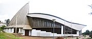
Sports Palace of Yaounde

Central Market ( Marché central )

.jpg)
.JPG)
_in_Yaound%C3%A9.JPG)
agreement
In 1963 and 1969, respectively, the Yaoundé Agreement was concluded with the European Community , which aimed to set up a free trade zone and remove trade barriers. These treaties were predecessors of the better known Lomé and Cotonou Conventions .
personalities
(Alphabetical)
- Patrice Abanda (born 1978), soccer player
- Vincent Aboubakar (born 1992), soccer player
- Joseph Akongo (born 1977), soccer player
- Brian Anunga (born 1996), soccer player
- Charles Atangana (c. 1883–1943), "chief chief of the Yaoundé and Bane", political leader of the Ewondo of Yaoundé
- Jules Baga (born 1987), soccer player
- David Bayiha (born 1986), soccer player
- Daniel Bekono (born 1978), soccer goalkeeper
- Françoise Bella (born 1983), soccer player
- Gilles Binya (born 1984), soccer player
- Petrus Boumal (born 1993), soccer player
- Paolo Dal Molin (born 1987), track and field athlete
- Biboul Darouiche (born 1963), percussionist and composer
- Patrick Ekeng (1990–2016), soccer player
- Paul Ekollo (born 1984), soccer player
- Rodrigue Ele (born 1998), soccer player
- Marie Gisèle Eleme Asse (born 1995), sprinter
- Joel Embiid (born 1994), basketball player
- Breel Embolo (born 1997), Swiss footballer
- Gaëlle Enganamouit (born 1992), soccer player
- Joël Epalle (born 1978), soccer player
- Narcisse Ewodo (born 1972), basketball player
- Marc-Vivien Foé (1975–2003), footballer
- Adrienne Ndongo Fouda (born 1990), soccer player
- Jeando Fuchs (born 1997), Cameroonian-French footballer
- Jérôme Guihoata (born 1994), soccer player
- Valery Hiek (born 1981), soccer player
- Mohamadou Idrissou (born 1980), soccer player
- Felix Kekoh (born 2001), soccer player
- Eric Kwekeu (born 1980), soccer player
- Jean Makoun (born 1983), soccer player
- Soulemanou Mandjombe (born 1992), soccer player
- Christine Manie (born 1984), soccer player
- Luc Mbah a Moute (born 1986), basketball player
- Stéphane Mbia (born 1986), soccer player
- Lorenzo Mbiahou (1977–2014), documentary filmmaker and cinematographer
- Matthew Mbuta (born 1985), soccer player
- Patrick Mevoungou (born 1986), soccer player
- Roger Milla (born 1952), soccer player
- Joseph Minala (born 1996), soccer player
- Phoenix Missi (born 2001), soccer player
- Youssoufa Moukoko (born 2004), German soccer player
- Ousseini Mounpain (born 1994), soccer player
- Patrice Nganang (born 1970), literary scholar and writer
- Gabrielle Ngaska (born 1988), soccer player
- Ariel Ngueukam (born 1988), soccer player
- Aaron Nguimbat (born 1978), soccer player
- Marlyse Bernadett Ngo Ndoumbouk (born 1985), soccer player
- Louis Ngwat-Mahop (born 1987), footballer
- Sandra Nkaké (born 1973), singer and actress
- Alain N'Kong (born 1979), soccer player
- Zacharie Noah (1937–2017), soccer player
- William Biassi Nyakwe (born 1991), footballer
- Florent Obama (born 1991), soccer player
- Dimitri Oberlin Mfomo (born 1997), Swiss football player
- Jean Onana (born 2000), soccer player
- Njongo Priso (born 1988), soccer player
- Isis Amareillle Sonkeng (born 1989), soccer player
- Samuel Umtiti (born 1993), French footballer
- Heinrich Vieter (1853–1914), Roman Catholic Bishop and First Vicar Apostolic of Cameroon
- Jeannette Yango (born 1993), soccer player
- Christian Zock (born 1994), soccer player
- Armand Zorn (born 1988), German politician (SPD)
- Francine Zouga (born 1987), soccer player
web links
itemizations
- ↑ All-pulations
- ↑ Lt. Notification to the Foreign Office on April 4, 1889; Federal Archives R 1001/3268, p. 14f
- ↑ German Embassy Yaoundé: 120 years of Yaoundé ( Memento of December 24, 2013 in the Internet Archive )
- ↑ World Urbanization Prospects - Population Division - United Nations. Retrieved July 23, 2018 .
- ↑ Mercer's 2018 Quality of Living Rankings. Retrieved August 18, 2018 (English).
- ↑ Société de transport et equipment collectifs de Yaoundé SA In: STECY.cm. Retrieved December 18, 2018 (French).
- ↑ Aéroport International de Yaoundé-Nsimalen (French), accessed 28 December 2020.
- ↑ Camrail - Railway transport of Passengers and freight , accessed 28 December 2020.
- ↑ Otto Sarrazin, Karl Schäfer: The government building in Cameroon , In: Centralblatt der (Prussian) building administration , No. 45, November 7, 1885.