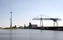
Magdeburg canal port

The Magdeburg Canal Harbor is one of the four Magdeburg harbors .
It is located in Magdeburg 's industrial area north and is the largest port in Magdeburg with an area of around 80 hectares
The canal port consists of the harbor basin I with the terminal Zweigkanal and the harbor basin II. The harbor basin I has a quay around 300 m long, harbor basin II a 1260 m long. Both together have 45,000 m² of paved outdoor storage space and 40,000 m² of unpaved outdoor storage space.
Most of the total handling of the Magdeburg port is handled at the canal port. Around 1 million tons of crude oil are handled annually. Other cargo handled are bulk and loose goods, general cargo, grain, animal feed, fertilizers and various metals as well as biodiesel. The canal port has several full-portal luffing cranes for this purpose .
An approximately 100 m wide, heaped up separation dam separates the port basin from the Stromelbe and the Rothensee connecting canal to the Magdeburg waterway intersection . The Trennungsdamm terminal with a quay length of 4,570 m is located at the Trennungsdamm. There are also 16,500 m² of paved open-air storage areas and 2,480 m² of covered storage areas.
The newly built low-water lock Magdeburg ensures that the water level in the port basin of the canal port is sufficient for shipping even when the water on the Elbe is low, so that the port of Magdeburg can be approached from the Mittelland Canal by normally loaded ships even at low tide.
Web links
- Magdeburg canal port on the website of the operating company of the Magdeburg ports
Individual evidence
Coordinates: 52 ° 11 ′ 23.7 " N , 11 ° 40 ′ 44.8" E

