Kanosero
| Kanosero | ||
|---|---|---|

|
||
| Geographical location | Murmansk Oblast ( Russia ) | |
| Tributaries | Umba , Kana , Muna , Tschornaja | |
| Drain | Conversion | |
| Data | ||
| Coordinates | 67 ° 2 ′ N , 34 ° 7 ′ E | |
|
|
||
| Altitude above sea level | 52 m | |
| surface | 84.3 km² | |
| length | 32 km | |
| width | 6 km | |
| Catchment area | 4920 km² | |
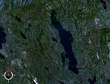
The Kanosero ( Russian Канозеро, Кано́зеро ) is a lake in the southwestern part of the Kola Peninsula in the Russian Murmansk Oblast .
The lake has an area of 84.3 km² and is at an altitude of 52 m. It has a length of 32 km and a maximum width of 6 km. The Umba ( Умба ) flows through the Kanosero from north to south. Other tributaries of the Kanosero are Kana ( Кана ), Muna ( Муна ) and Tschornaja ( Чёрная ). The lake is left by the two outlets Kiza ( Кица ) and Rodwinga ( Родвинга ), which reunite in Lake Pontschosero , 10 km to the south, to form the Umba, which finally flows into the White Sea . The Kanosero is covered with ice between the end of October and the end of May.
In 1997, rock carvings were found on an island in the southwestern part of the lake .
Web links
Individual evidence
- ↑ a b Kanosero in the State Water Register of the Russian Federation (Russian)

