
Cape Agulhas


The Cape Agulhas ( Portuguese Cabo das Agulhas for, Cape Agulhas'; Afrikaans Kaap Agulhas , English Cape Agulhas ) is the southernmost point of the African continent, not, as is often assumed, the Cape of Good Hope . The 20th meridian , on which Cape Agulhas lies roughly (exactly it runs approx. 150 m east), represents the geographical border between the Atlantic and Indian Oceans .
The continental shelf in front of the Cape extends over 250 kilometers seaward; the waters around the cape are among the richest in fish on the South African coast.
The first known European navigator to reach Cape Agulhas in 1488 was the Portuguese Bartolomeu Dias . Cabo das Agulhas is Portuguese for 'Cape of the Needles'. Probably the seafarers gave it the name because of its numerous rocks and reefs. The meeting of different ocean currents often leads to high waves, the waters around Cape Agulhas are therefore very dangerous because of the reefs. Another theory is that in the 15th century there the compass needle pointed exactly to the geographic North Pole , i.e. H. the magnetic declination was exactly 0 °.
The warm Agulhas Current , which Vasco da Gama first described on his first trip to India in 1497/98, is named after Cape Agulhas .
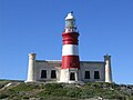
The lighthouse at Cape Agulhas

Climb to the upper platform


Trivia
The Agulhas long-beaked lobster is named after the cape.
See also
- Cap Vert (western tip of Africa)
- Cape Guardafui (eastern tip of Africa)
- Ras ben Sakka (northern tip of Africa)

Web links
Single receipts
- ^ Rudolf Pätzold: Compendium of Larks. All the larks on earth. Jan-Schimkat-Medienpublikation, Dresden 2003, ISBN 3-00-011219-7 .
Coordinates: 34 ° 50 ′ 0 ″ S , 20 ° 0 ′ 0 ″ E