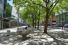
Capuchin planks
Kapuzinerplanken is the official street name for a square in downtown Mannheim . It extends over parts of the squares O 5 and O 6 opposite the squares N 5 and N 6 along the so-called Kunststraße .
history
The name of the square goes back to the Capuchin monastery , which was located in the squares N 5 and N 6 from 1701 to 1839/1840. The area was assigned to the Capuchin Order by Elector Johann Wilhelm II in 1699 . At that time, these two squares extended further north, beyond today's street (so-called art street ) to today's Kapuzinerplanken. The church even stood exactly where the street runs today. Only with the demolition of the church and monastery after 1838 was the new street layout created according to the present-day squares and the former monastery grounds were cut through. The Kapuzinerplanken are the northern remainder of the monastery area.
description
The Kapuzinerplanken is a pedestrian zone, planted with trees and suitable for smaller events, about 145 m long and 20 m wide. In O 5 and O 6 they run parallel to the large planks that, as part of the Mannheim pedestrian zone, lead from the water tower to the Paradeplatz . On the Kapuzinerplanken in O 5 there is a monument to Blumepeter , a Mannheim original.
The Kapuzinerplanken is not infrequently confused with the "Kapuzinerplatz" located diagonally opposite in N 4, which is also named after the Capuchin monastery and is popularly known as the Gockelsmarkt .
Regular events
- Organic weekly market, Fridays from 12:00 p.m. to 7:00 p.m.
- In summer, the square is the starting point for the 14-day inline skating runs .
- In December there is a smaller Christmas market , which is decorated in white over the holidays and then continues as a New Year's Eve market until the end of the year.
- Various retail events / markets mainly from Engelhorn (e.g. Christmas market, Easter market, craft market, etc.)
See also
Web links
- City board Capuchin monastery. (PDF, 1.3 MB) City of Mannheim, accessed on March 25, 2015 .
- Capuchin monastery Mannheim at LEO-BW, discover regional studies online
Individual evidence
- ↑ MARCHIVUM: street names, Kapuzinerplanken. Retrieved August 27, 2018 .
Coordinates: 49 ° 29 ′ 8 " N , 8 ° 28 ′ 11.2" E

