
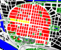
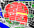
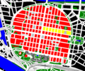
Square city


Quadratestadt is an epithet of the city of Mannheim , whose historic city center is laid out as a planned city in blocks instead of streets. Hardly any of these 144 “squares” is a square in the sense of geometry - rather, it is mostly different quadrilaterals . There are rectangular , rhombic and trapezoidal "squares" as well as two triangles. Occasionally two squares are connected to form a rectangle because there is no road between them. In everyday use, the entire city center is referred to as “the squares”, which means all streets surrounded by the ring roads, including buildings and squares.
This also explains the city administration's modern logo: Mannheim² (for Mannheim in a square ).
history

In 1606, Elector Friedrich IV of the Palatinate laid the foundation stone for the construction of the Friedrichsburg Citadel and commissioned the Dutch fortress architect Bartel Janson to plan the neighboring city. The ideals applicable to planned cities were strongly influenced by military aspects. This is how the regular system of geometric shapes, which is characteristic of Mannheim to this day, emerged with parallel streets crossing at right angles and uniform block development.
Until 1684, Mannheim had street names in the city center like any other city. They were each referred to as "Gasz" ("Gasse"), for example "Mauritz Gasz", "Ludwigs Gasz", "Friederichs Gasz". When the unusual numbering was introduced, the inhabitants of Mannheim still stuck to the old street names. This first numbering differed from today's: today's square P 1 was, for example, square XXXI, today's square E 1 was square XXXII. The Friedrichsburg castle, which stretched from the palace to the Mannheim planks , was excluded from this numbering . When this area was incorporated into the city in the 18th century, the numbering changed too.
The division into squares remained in place even after the destruction by the French in 1689 during the War of the Palatinate Succession and the reconstruction. After the remeasurement in the 1730s, the squares were designated with letters for the first time. In 1798 the city was redistributed and the apartment blocks were designated with letters (initially from A to Z; today from A to U) and numbers.
The current system of squares with letters and numbers was introduced in 1811. The previous division was no longer suitable for a city center that extended to the west and east and therefore required numbering that could be scaled to both sides.
Scheme

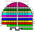
The horseshoe-shaped city center of Mannheim lies between the Rhine and Neckar , just under 3.5 km from the mouth of the Neckar . The Mannheim Palace stands in the southwest as a kind of baseline. From here the 1.1 km long “ Breite Straße ”, whose official name is Kurpfalzstraße , runs in the sense of a vertical central axis to the northeast through the city center. About halfway up it is crossed by the 1.4 km long “planks” in the area D 1 / E 1 and O 1 / P 1 (O 1 corresponds to the Paradeplatz). The other streets running parallel to these two main axes divide the city center into rectangular blocks, which are colloquially known as “squares”. Most of the streets in the city center have no name, but the "squares" are named from a combination of letters and numbers. At first glance, one might assume, the city is oriented in a north-south direction, in fact, it is about 32 degrees in a clockwise rotated.
Comparison with a chess board
Even if the comparison with a checkerboard pattern is obvious, the similarities are limited. The Mannheim “chess board” has the shape of an inverted “U” and is divided into a left and a right half. There are also rows that are longer and go beyond the frame of a chess board.

Numbering on a chess board

Simplified Mannheim numbering
Mannheim scheme, simplified


Streets
The ring
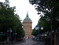
The arches of Kaiserring, Friedrichsring, Luisenring and Parkring together with the straight baseline (Bismarckstraße) form the horseshoe-shaped outline of the city center, the so-called ring , at the base of which the castle is located. The ring was only laid out around the inner city area from 1865 until the turn of the century and was initially known as the "Ringstrasse". The first part of the ring was built in the former trenches from Rheinstrasse to the gasworks at that time (now around K 7). The Parkring in the west was named after the former Friedrichspark at the castle, the Luisenring in the northwest after Luise of Prussia , Grand Duchess of Baden. The Friedrichsring, named after Friedrich I , Grand Duke of Baden, begins at the Kurpfalzkreisel ( Kurpfalzbrücke ) in the northeast . In the east, the Kaiserring runs between the water tower and the main train station as far as Bismarckstrasse. This was completed last, initially through the former tree nursery gardens from the Kaiserring to the castle and was later extended by the former front area of the castle. The ring was laid out generously from the start - the Kaiserring, for example, was planned to be 54 m wide in 1875 - and has been expanded to at least four lanes everywhere. Except on the Parkring, a tram track runs in the middle , on the Luisenring partly underground.
On July 3, 1886, on the Ringstrasse , Carl Benz carried out the first ever test drive of an automobile in his patented motor vehicle .
Streets in squares
The most important streets in the city center are the Planken (water tower axis), the Kunststraße and Fressgasse (the two next streets parallel to the Planken) and, perpendicular to this, the Breite Straße ( Kurpfalzbrücke- castle axis). On the one hand, they are the main streets with most shops and, on the other hand, they divide the city center into four large areas, each of which is connected to the suburbs.

With a few exceptions, the streets in the squares themselves have no official street names. This also applies to the aforementioned planks, the Fressgasse and others. Some popular or historical street names are used for orientation, but cannot be found on any street sign. The addresses are only formed by the square names with associated house numbers, for example D 6, 2. Street names were introduced in the squares as early as 1865, but were generally not used.
A special feature applies to the addresses along the ring: The inner sides of the squares are based on the system of squares; on the outside of the ring, on the other hand, the addresses are regularly formed from the respective street name and house number. For example, N 7, 12 is opposite Kaiserring 46.

Naming scheme
“Coordinate system” of the squares
The naming of the 144 squares does not appear comprehensible for non-residents without further knowledge, but is based on a simple scheme.
- The Kurpfalzstraße ("Breite Straße"), which starts from the castle in a northerly direction to the Kurpfalzbrücke, forms a central axis and divides the city center (which is roughly the shape of an inverted U) into a left and a right area.
- The horizontal rows of the squares to the left of the center, starting at the lock, have the letters A to K,
- the squares to the right of it correspond to L to U.
- Within the rows, the numbers of the squares indicate the distance from the "Breite Straße".
- A square designation like G 1 - the market square - should therefore be interpreted as follows: The letter G lies between A and K, so the square is to the left of Kurpfalzstrasse. There are seven letters from A to G, so the square is in the 7th row from the lock. Because of the number 1, the square is the first from the middle, so it is right on Kurpfalzstrasse.
- There are mostly seven squares per letter. The number can vary depending on the location and size. In the left area, the A row consists of 5 squares and the C row of 8, on the right S, T and U end after 6 squares. The L row (first row on the right) includes squares north and south of Bismarckstrasse and therefore counts up to L 15.
House numbers in the squares
The house numbers start at the corner of the respective square facing the lock.
- For the squares A to K on the left, they run counterclockwise around the square.
- In the squares L to U, the house numbers are reversed clockwise.
When determining the house number system, the electoral town planners supposedly had the following visual idea: The castle is a fountain, the fountain of which shoots up between the squares A 1 / L 1 up to K 1 / U 1. The squares are then the falling water. Accordingly, the "sense of rotation" to the left of the fountain is to the left (counterclockwise) and to the right of the fountain to the right.
From the castle to the planks (left)
The squares between the lock and the plank (left) form as inner-southwest quadrant the municipality Western upper town (A-D).
A squares
The A-squares were one of the best addresses in Mannheim - Friedrich Engelhorn , for example , who later founded BASF , lived here.
In addition, parts of the University of Mannheim are located in these squares and with the historical observatory , the Jesuit church and the Palais Bretzenheim, some of the few buildings that remain from the time of the electorate.

A squares (yellow)
Regional court in A 1

University building with Audimax , behind it the Jesuit Church


| Until 1733/ 1735 |
1735 - 1774 |
1774 Karg |
1774 - 1794 |
1794 - 1811 |
1811 - 1850 |
1850 - 1870 |
1870 - today |
Remarks |
|---|---|---|---|---|---|---|---|---|
| EE | 104 | 85 | 93 | A 1 | A 1 | A 1 | A 1 | The most famous building in the square was the Engelhornsche Palais in A 1, 2–3 in the Italian palazzo style. It was the home of the industrialist Friedrich Engelhorn , the founder of BASF . At the beginning of the 20th century, the Mannheimer Sparkasse took over the building and used it until 1954, before moving to square D 1. Although hardly damaged in the Second World War, the building was demolished to make way for a new building for the Mannheim District Court , which takes up the entire built-up area of the A1. The building by the architect Helmut Striffler catches the eye with its rust-brown COR-TEN steel cladding on the upper floors. It was the first time that an architect used rust steel to clad buildings in Germany. |
| FF | 105 | 86 | 94 | A 2 | A 2 | A 2 | A 2 | The Palais Bretzenheim in A 2, 1 - directly opposite the palace - is one of the most important historical Mannheim noble houses and was built from 1782 to 1788 according to plans by the court architect Peter Anton von Verschaffelt . In this building, the elector Carl Theodor had his maitresse , the dancer Josepha Seyffert-Heydeck and their four children together, whom Wolfgang Amadeus Mozart gave piano lessons here. In building A 2, 5 the student Karl Ludwig Sand murdered the Russian State Councilor August von Kotzebue on March 23, 1819 . This house later belonged to the Heinrich Lanz family . It then passed into the possession of the Niederbronn sisters , who opened the Sankt Hedwig Clinic here , a hospital with a maternity hospital . |
| GG | 106 | 87 | 95 | A 3 | A 3 | A 3 | A 3 | A 3, 1–8 is the university library built by Gottfried Böhm and Jürgen Minkus in 1986–1988 . The library building with reading room and lecture hall is located on a plot of land that was built on with the former Sodality Church until it was destroyed in World War II. Striking details are the tree sculptures cast in concrete, which show architectural and urban motifs as visible supports. |
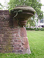
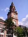
| HH | 107 | 88 | - | A 4 | A 4 | A 4 | A 4 | The Jesuit Church , the Mannheim observatory and the Ursuline grammar school are in A 4 . The Jesuit Church (A 4, 3) is now a Catholic parish church, consecrated to Saints Ignace and Francis Xavier and built between 1738 and 1760 under the court architect Alessandro Galli da Bibiena . The monumental church with a double tower facade is repeatedly referred to as the most important baroque church in southwest Germany. But this can also be an indication that there are not so many important Baroque churches in southwest Germany. The former observatory in A 4, 6 was built at the instigation of the Jesuit priest and court astronomer Christian Mayer on behalf of Elector Karl Theodor. The building is oriented exactly in the four cardinal directions and is therefore at an angle to the Jesuit church. |
| - | - | - | - | - | - | - | A 5 | A 5, the youngest “square”, was not separated from the palace garden by the road layout until 1960, when the driveway to Konrad-Adenauer-Brücke was redesigned and Bismarckstraße was continued straight from the palace. The library and seminar buildings of the University of Mannheim were built here as part of the campus in close proximity to the university facilities in the palace. Since 2006, the Mannheim Center for European Social Research has also been located in square A 5 , which was previously located in square L 7 together with the Center for European Economic Research . |
B squares

B squares (yellow)

Building of the Institute for Technical Computer Science at Heidelberg University , B 6
Historical view of the old national theater


| Until 1733/ 1735 |
1735 - 1774 |
1774 Plan Karg |
1774 - 1794 |
1794 - 1811 |
1811 - 1850 |
1850 - 1870 |
1870 - today |
Remarks |
|---|---|---|---|---|---|---|---|---|
| W. | 94 | 80 | 89 | B 1 | B 1 | B 1 | B 1 | In B 1 stood the "Heckerhaus" (destroyed by bombs in World War II), in which the revolutionary Friedrich Hecker lived as an attorney at court and member of the Baden state parliament. Hoffmann von Fallersleben also visited him there . With his wild beard and his "Heckerhut" He was the symbol of the uprising of 1848. Hecker fled to Switzerland and later to the United States , yet that was still Hecker song sung. |
| X | 95 | 81 | 90 | B 2 | B 2 | B 2 | B 2 | Wolfgang Amadeus Mozart lived in B 2 when he was seven years old when he played for the Elector in Schwetzingen in 1763 . In B 2, 1 is the loan office, in B 2, 12 one of the few Mannheim baroque houses. Between the two baroque houses in B 2, 12 and B 2, 14, on a 7.5 meter wide rubble site, the architect Helmut Striffler built the residential and commercial building of a private client in the early 1970s. |
| Y | 96 | 82 | - | B 3 | B 3 | B 3 | B 3 | In B 3 am Schillerplatz the former electoral fruit and granary has been converted into a theater from 1775 to 1776, the old National Theater , where 1782 The robbers of Friedrich Schiller was premiered. The actors Albert Bassermann and August Wilhelm Iffland played here . Wilhelm Furtwängler and Eugen Jochum worked here as directors . During the night air raid on 5./6. September 1943, during a performance by Carl Maria von Weber's Freischütz , it was bombed by the Royal Air Force and burned down completely. In addition to a statue of Schiller, there is also a memorial for the work of the rubble women in the reconstruction of the city. |
| Z | 97 | 83 | 91 | B 4 | B 4 | B 4 | B 4 | Carl Maria von Weber lived in the corner house B 4, 1 in 1810 . B 4, 1–5 is now a modern residential complex. Aloysia Weber, the composer's cousin, who lived in the A-squares, was often visited by Wolfgang Amadeus Mozart . When he was no longer needed for musical training, he could leave. Mozart later married Aloysia's sister Constanze . In B 4, 9 and B 4 10-10a there are former safe and office buildings of the Rheinische Kreditbank , which were planned by Albert Friedrich Speer in 1905. Today the extension is the depot of the Reiss-Engelhorn-Museum . |
| - | 98 | 84 | 92 | B 5 | B 5 | B 5 | B 5 | The Schillerhaus Museum of the Reiss-Engelhorn Museum is located on B 5, 7 . During his time in Mannheim from 1783 to 1785, Friedrich Schiller lived in various places. His last apartment was in Hölzel's house in B 5, 8, which is no longer preserved today. When Schiller's contract at the Mannheim Theater was not extended in 1784 and his creditors in Stuttgart pressed him, he was threatened with trial. In this predicament, his landlord, Anton Hölzel, scrapes together his savings and gives him the required amount. The Hölzel family were grateful to him that the trained physician Schiller cured their son from a serious illness. |
| - | 86 | - | - | C 8 | C 8 | B 6 | B 6 | The building of the Institute for Technical Computer Science at the University of Mannheim has been located in B 6, 26–29 since May 2005 , and has been part of Heidelberg University since 2008 . The completely renovated, listed Rhenania building from the 19th century is flanked by two new buildings, the lecture hall building and the laboratory building. |
| - | - | - | - | - | - | - | B 7 |
The student residence of the same name with around 100 places is located in square B 7. |
C squares
C squares (yellow)
List school with equestrian figure of city founder Friedrich I.
Birthplace Alfred Delp
Reiss-Engelhorn museums in the armory


| Until 1733/ 1735 |
1735 - 1774 |
1774 Karg |
1774 - 1794 |
1794 - 1811 |
1811 - 1850 |
1850 - 1870 |
1870 - today |
Remarks |
|---|---|---|---|---|---|---|---|---|
| N | 62 | 75 | 74 | C 1 | C 1 | C 1 | C 1 | The former Princess Katarine of Saarbrücken lived in C 1, 2 on Breiten Strasse under the title Countess von Ottweiler from 1795 to 1829. Katharina Margareta von Ludwigsburg (1784–1829) was a former goose maid, the Hereditary Prince Ludwig of Nassau-Saarbrücken to his second wife made and raised as Countess of Ottweiler to the nobility. Because of its simple origin it was called Gänsegretel by the people . She was known to be a cranky person. She surrounded herself with a large number of cats, which is why she was nicknamed "Cat Countess". In the same square, C 1, 6–7, directly on Paradeplatz, there is now the Thalia bookstore (formerly Kober and Löffler Fachbuch), whose specialty is the reading night held twice a year, during which visitors browse through the books until late at night can. |
| O | 69 | 76 | 75 | C 2 | C 2 | C 2 | C 2 | |
| P | 70 | 77 | 76 | C 3 | C 3 | C 3 | C 3 | Many inns in the B and C squares claim that Friedrich Schiller has stayed with them, for example the Weinhaus Hunzinger ( Fliegender Holländer ) in C 3, 20. He seems to have been very satisfied with the drinks there: “A fine wine “Should have been his comment about the wine list . |
| Q | 77 | 78 | 77 | C 4 | C 4 | C 4 | C 4 | The Palais Cunzmann is in C 4, 9b. The house has served as a restaurant near the former National Theater since 1873 . That is why it has been given the name "Zwischenakt", which is still used today. Later it was the seat of the Volksbank , today the institute for international art and cultural history of the Reiss-Engelhorn-Museum is located there . In C 4, 12 there was the Jewish restaurant Kaufmann, which was also used as a prayer room at times. |
| - | 78 | - | - | C 5 | C 5 | C 5 | C 5 | The Zeughaus Museum for Art, City and Theater History of the Reiss-Engelhorn Museum is located in C 5 . The 1778 by Peter Anton von Verschaffelt built armory was equipment Chamber of Palatine army , later barracks , then exhibition hall of the trade association and last pawn shop . After its destruction in the Second World War, it was restored in 1957 and, as the Carl Reiss Museum, housed the Mannheim city history and ethnographic collections. The foundation was the foundation of the Mannheim patron Carl Reiss and his sister, who bequeathed six million marks to the city in 1913 . On the Toulonplatz (named after the twin town of Toulon ) in front of the armory, the plan of the former garrison church is marked in the pavement. |
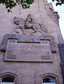
| LXI | 85 | - | - | C 6 | C 6 | C 6 | C 6 | The Friedrich-List-Schule is located in C 6, 1, a commercial school that was previously called the Kurfürst-Friedrich-Schule. Although the construction of the building was completed in 1906, it was not inaugurated until 1907, on the 300th anniversary of Mannheim. On this occasion, the facade relief with the equestrian figure of the city founder, Elector Friedrich , after whom the school had its previous name, was unveiled. An urban accent is the five-story tower-shaped corner building on the armory planks. |
| - | - | - | - | C 7 | C 7 | C 7 | C 7 | At the house C7, former Wöchnerinnenasyl Luisenheim was on 15 September 2003, the 97th birthday Alfred Delp , who was born here, unveiled a plaque on which states in part: There are even others may live happier, because we died are! These were the words Delp wrote after the death sentence was pronounced against him in January 1945. |
| - | - | - | - | - | - | C 7 | C 8 | This square is - except in the L-squares - the only one that has a number higher than 7. |
D squares

D squares (yellow)
Bankhaus Ladenburg in D 3, 12

Pyramid in front of the Reiss Museum


| Until 1733/ 1735 |
1735 - 1774 |
1774 Karg |
1774 - 1794 |
1794 - 1811 |
1811 - 1850 |
1850 - 1870 |
1870 - today |
Remarks |
|---|---|---|---|---|---|---|---|---|
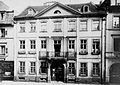
| E. | 63 | 69 | 68 | D 1 | D 1 | D 1 | D 1 | The D-squares start at the corner of Paradeplatz. This is where the Palatinate Court stood , one of the first hotels in the city, whose prominent guests included Tsar Paul I , who stayed here as Crown Prince in 1782. Wolfgang Amadeus Mozart lived with his mother in the Palatinate Court until the stay there became too expensive for both of them. They often sat freezing in the room because they had to pay extra for the firewood. The flutist Johann Baptist Wendling arranged for them to find new accommodation at Serrarius, where Mozart was able to earn his lodging money by giving the daughter of the house piano lessons. The Sparkasse Rhein Neckar Nord is located in D 1, 1–3 . The building of the clothing department store C&A is in D 1, 4–8 . |
| F. | 68 | 70 | 69 | D 2 | D 2 | D 2 | D 2 | In square D 2 was the Schwan bookstore, which, along with Löffler, was the first to print Friedrich Schiller's play Räuber (first edition: Mannheim: Schwan'sche Buchhandlung, 1782). |
| G | 71 | 71 | 70 | D 3 | D 3 | D 3 | D 3 | Friedrich Engelhorn completed his apprenticeship as a goldsmith in square D 3 . At the Ladenburg W. H. Ladenburg & Sons bank , a predecessor of Deutsche Bank , Engelhorn signed the articles of association with the banker Ladenburg and a few other personalities, which led to the founding of BASF . |
| H | 76 | 72 | 71 | D 4 | D 4 | D 4 | D 4 | The Mannheim Municipal Loan Office is located in D 4, 9-10 , which was founded in 1809 with the approval of Grand Duke Carl Friedrich von Baden. The pawnshop was supposed to counteract the usurious hustle and bustle of private pawnbrokers and thus “serve the best of the needy class” . It is currently the only municipal lending office in Germany from 35. |
| LI | 79 | 72 | 72 | D 5 | D 5 | D 5 | D 5 | The Museum of Archeology and Cultures of the World of the Reiss-Engelhorn Museum is located in D 5 . Changing special exhibitions also take place here. In front of the museum is a work of art with objects found in walls from the ruins of the Second World War. Here is also a plaque on which the Goethe quote from the epic Hermann and Dorothea , often quoted in Mannheim, is:
|
| LX | 84 | 74 | 73 | D 6 | D 6 | D 6 | D 6 | The Curt Engelhorn Center Archäometrie gGmbH and the Curt Engelhorn Foundation of the Reiss Engelhorn Museum are located in D 6 . The Curt Engelhorn Center for Archaeometry deals with archaeometry , a discipline of scientific archeology for the clarification of archaeological as well as art and cultural-historical questions with methods of natural science . The Klapsmühl 'Kleinkunstbühne , a local cabaret theater , is located in D 6, 3 . The mayor of Mannheim Heinrich Christian Diffené was born in the restaurant Silberner Schlüssel in D 6, 11 and the Mannheimer Liedertafel was founded in 1840 , to which only those who could either write, compose or sing a song could become members. |
| - | - | - | - | - | D 7 | D 7 | D 7 | The Schott house is in D 7, 5, the Elisabeth Gymnasium in D 7, 8. The "Elisabeth" was founded in 1863 by progressive Mannheim citizens and has been housed in a building since 1905 that was built by the city architect Richard Perrey . It is named after Catharina Elisabeth Goethe , the mother of Johann Wolfgang Goethe . In D 7, 8 ?? stood the late classicist Bassermann house from the time before 1840, which was demolished in 1902/03 in favor of a higher secondary school for girls and girls. The Bassermann house was built in 1829 by Jakob Friedrich Dyckerhoff for Friedrich and Wilhelmine Bassermann, for which three old houses had to be demolished. Friedrich Daniel Bassermann moved in as a member of the Paulskirche in Frankfurt in 1848 . He could never get over the failure of the reforms and so he committed suicide in 1855 on the same day as his parents celebrated their golden wedding anniversary. He was remembered as an upright citizen, even if the word of the Bassermann figures suggests otherwise, as it was twisted by his political opponents. Bassermann had actually said in 1848 in the Frankfurt National Assembly about the situation in Berlin:
|
From the planks to the Neckar (left)
The squares between the planks and the Neckar (left) form the north-western inner city quadrant of the city district Westliche Unterstadt (E – K).
E squares
E squares (yellow)

The town hall in E 5

Cafe Herrdegen

Mannheim Angel of Peace by Gerhard Marcks

Wooden door with the year inscription 1774 in E 3, 9


.jpg)
| Until 1733/ 1735 |
1735 - 1774 |
1774 Karg |
1774 - 1794 |
1794 - 1811 |
1811 - 1850 |
1850 - 1870 |
1870 - today |
Remarks |
|---|---|---|---|---|---|---|---|---|
| XXXII | 64 | 62 | 61 | E 1 | E 1 | E 1 | E 1 | In square E 1 stood the Jewish department store Wronker , which tried to protect itself against the theft of its cutlery in the refreshment room by having the words “Stolen at Wronker” engraved on the handles. In 1934 Kaufhaus Hansa ( Hertie ) took over the business and later even took up the entire square E 1. When Hertie was taken over by Karstadt AG in 1994 , this meant the end of the department store. It was closed in 1995. The building was gutted, partially demolished and rebuilt as a commercial and office building.
Today the stores H&M , Esprit , Deichmann and Rossmann are located in E 1 . |
| XL | 67 | 63 | 62 | E 2 | E 2 | E 2 | E 2 | E 2, 8 is where the Herrdegen pastry shop is located , which has been making Mannheim dirt according to a traditional recipe since the 19th century . In 1766 , Tobias Löffler founded his bookstore, which is still in existence today, in the Zum golden Leuchter house in E 2, 5 . |
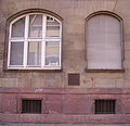
| XLI | 72 | 64 | 63 | E 3 | E 3 | E 3 | E 3 | E 3, 16 is a listed Wilhelminian style bank building. |
| L. | 75 | 65 | 64 | 65 | E 4 | E 4 | E 4 | Land E 4, 12-16 is occupied by the stock exchange. The Mannheim Stock Exchange, founded in 1862, had no meeting place of its own for over three decades and therefore had to change location several times before setting up its own building here. The specially founded Börsenbau-AG acquired four plots of land and had the buildings here, including the Great Mayerhof and the Hotel Portugal, demolished in order to erect a representative large building from around 1900. |
| LII | 80 | 66 | 65 | E 5 | E 5 | E 5 | E 5 | The town hall in E 5 was built in 1936 in the square E 5, which was laid down when the planks were breached, and shows features of the neo-classicist representational buildings of National Socialism. The floor plan of the town hall has the shape of the letter "H". There is no evidence of any reference to the name "Hitler". The architect Josef Zizler himself spoke of a double "T". After war damage to the as yet unfinished building, the city's head office and mayor have had their headquarters in the building since 1951. |
| LIX | 83 | 67 | 66 | C 8 | C 8 | E 6 | E 6 | In E 6, there is the Catholic Bürgerhospital with the hospital church built by Johann Faxlunger and Peter Anton von Verschaffelt . The hospital, founded in 1775 as a poor and emergency house, has been located here since 1784. According to the statute, it was “the care of poor Catholic sick and needy people” . In the early years there were first, second and third class needy people. The first included the inmates "from the local bourgeoisie" , the second those from the servants and the third "inmates from the class of servants of Catholic citizens as well as Catholic public servants" . In the 1930s, the Bürgerhospital stood in the way of widening the planks and was rebuilt between 1937 and 1939, offset by several meters. Also in E 6, behind the church of the community hospital, stands the Mannheim Angel of Peace , a sculpture by the sculptor Gerhard Marcks , which was moved here in 1983 from its location in B 4 at the entrance of the "Kalten Gass" near the Jesuit church.
|
| LIX½ | 87 | 68 | 67 | E 7 | E 7 | E 7 | E 7 | In E 7, 20 was the Reiss'sche Villa, in which Consul Carl Reiss lived with his sister Anna. In 1915, the villa came into the possession of the municipality by will and became the official villa of the mayor of Mannheim for a few years. E 7, 23–24 are two art nouveau houses. 18 years after building his residential and studio building in E 7, 7 , Carlfried Mutschler and Joachim Langner created a second residential and office building on the neighboring corner property in E 7, 5. |
F squares
F squares (yellow)

Old Town Hall and St. Sebastian Church

Old main synagogue , 1855


| Until 1733/ 1735 |
1735 - 1774 |
1774 Karg |
1774 - 1794 |
1794 - 1811 |
1811 - 1850 |
1850 - 1870 |
1870 - today |
Remarks |
|---|---|---|---|---|---|---|---|---|
| XXXIII | 65 | 55 | 54 | F 1 | F 1 | F 1 | F 1 | F 1, 5–6 occupy the two assembled buildings of the Old Town Hall and the Catholic St. Sebastian Church . The town hall, built from 1700 onwards, was connected to the Catholic St. Sebastian's Church at the request of the Elector, and thus architecturally indicated the change from the Protestant to the Catholic branch of the Electors. The representative design corresponded to the fact that the town hall and church received the central tower facade characteristic of Mannheim . In addition to the main synagogue, Mannheim had so-called Klausen, Jewish houses of learning that were used for Torah and Talmud studies . The most important was the Lemle-Moses-Klaus in F 1, 11, named after its founder . The marketplace guard of the municipal security service of the city of Mannheim is located in F 1, 5a. |
| XXXIX | 66 | 56 | 55 | F 2 | F 2 | F 2 | F 2 | At the corner of F 2 stood the Mannheim main synagogue , which was burned down during the November pogroms in 1938 . The main synagogue in F 2, 13 and the Klaus Synagogue in F 1, 11, first mentioned in 1670, served as the religious focal point of a Jewish community of 6,500 people in the early 1930s. |
| XLII | 73 | 57 | 56 | F 3 | F 3 | F 3 | F 3 | Wolfgang Amadeus Mozart and his mother lived in the house of Hofkammerrat Anton Joseph Serrarius , in F 3, 5 from December 10, 1777 until he left for Paris in March 1778 . Instead of paying rent, he teaches his stepdaughter Therese Pierron on the piano. Mozart wrote most of his Mannheim compositions here. A large part of the F 3 square is now occupied by the new Mannheim synagogue and the Jewish community center. The city’s desire to revitalize the fallow district and to create affordable apartments meant that the building program was expanded to include shops, kindergartens, old people’s, student and social housing. The synagogue on the north side of the square is enclosed in a U-shape by a five-story residential and commercial building.
|
| XLIX | 74 | 58 | 57 | F 4 | F 4 | F 4 | F 4 | This is where the 4-star Hotel Wyndham Mannheim is located. |
| LIII | 81 | 59 | 58 | F 5 | F 5 | F 5 | F 5 | F 5, 19 was significant in connection with the revolution of 1848 . Here in Moritz Hähner's (1803–1877) printing works, the “ Mannheimer Abendzeitung ” was printed, a democratic paper that was also widely distributed and recognized. |
| LIII | 82 | 60 | 59 | F 6 | F 6 | F 6 | F 6 | F 6, 1 from 1758 to 1804 Mannheim drawing academy in the art academy building, destroyed in World War II. |
| LVIII | 88 | 61 | 60 | F 7 | F 7 | F 7 | F 7 | The former Jewish cemetery has been located in F 7 since 1661. In 1839, when the city and synagogue council agreed on the establishment of a new cemetery following the main city cemetery , which was being planned, the Jewish cemetery was also relocated. |
G squares

G-squares (yellow)

Old Trinity Church

new Trinity Church


| Until 1733/ 1735 |
1735 - 1774 |
1774 Karg |
1774 - 1794 |
1794 - 1811 |
1811 - 1850 |
1850 - 1870 |
1870 - today |
Remarks |
|---|---|---|---|---|---|---|---|---|
| XXXIII½ | 43 | - | - | G 1 | G 1 | G 1 | G 1 | The gallows used to stand on the market square , G 1. On May 10, 1933, the National Socialists burned books here . Today the Mannheimer Markt takes place at the same location. When it was rebuilt from 1700 onwards, the market square lost its central location due to the expansion of the city to the south. The new center became the Paradeplatz in O 1. The fountain in the middle of the market square was donated to the city of Mannheim in 1767 by Elector Karl Theodor . The fountain figures from 1719 were not originally intended for Mannheim, but for the Heidelberg Castle Gardens. They were revised and supplemented for the installation in Mannheim. The sculptor and restorer Hans-Volker Dursy restored the market square fountain from 1978–1981 and replaced the original figures with replicas made of epoxy resin . |
| XXXVIII | 48 | 50 | 36 | G 2 | G 2 | G 2 | G 2 | On September 30, 1815, Johann Wolfgang von Goethe stayed at the Drei Könige restaurant on his seventh visit to Mannheim with his patron Grand Duke Carl August . |
| XLIII | 49 | 51 | 37 | G 3 | G 3 | G 3 | G 3 | |
| XLVIII | 56 | 52 | 38 | G 4 | G 4 | G 4 | G 4 | The former Lutheran Trinity Church in G 4, 1–4 from the years 1704–1706 was one of the oldest buildings in the city, along with the old town hall and the Catholic church on the market square. The church was overcrowded during the services of Pastor Erwin Eckert , who belonged to the "Religious Socialists" and later became a communist. Until it was destroyed in World War II, it faced north, unlike today's building, with a squat bell tower. After it was destroyed in 1943 except for the remains of the surrounding wall, a completely new church was to be built. The architect Helmut Striffler created a consistently modern church, which was highly praised by architecture critics but is little loved by the parish. The 57 meter high tower can be seen from afar. The church building is no longer used for worship. |
| LIV | 57 | 53 | 39 | G 5 | G 5 | G 5 | G 5 | The residential complexes of the non-profit construction company in G 5 / G 6 were created as parallel lines. |
| LVII | 61 | 54 | 40 | G 6 | G 6 | G 6 | G 6 | The Apollo theater was in G 6 . It was built in 1897 and demolished in 1935 as part of the renovation of the old town. Among others, the juggler Enrico Rastelli , the film actress Asta Nielsen , the humorist Otto Reutter and the singer Richard Tauber performed here . In place of the old houses there were block-edge buildings with inner courtyards. In 1935, the "Apollo" had to give way to National Socialist town planning. Between 1933 and 1937, the entire G 6 square was demolished and rebuilt under the slogan “Loosening up, clearing and healing the old town” . |
| - | - | - | - | - | - | G 7 | G 7 | G 7 is the only square that is almost divided into two halves by a dead end with a turning loop leading into the square . Around 1900 there were numerous tobacco companies in G 7 in which women workers made cigarettes. In G 7, 18, the Islamic Association of Mannheim has maintained a rear mosque since 1972. When the city of Mannheim declared the square a redevelopment area in 1984, a replacement had to be found, which ultimately led to the construction of the Yavuz Sultan Selim mosque in the Jungbusch district opposite . |
H squares
The H and I squares, as well as the S and T squares, were in the shadow of the fortress wall that surrounded Mannheim at the time.

H squares (yellow)
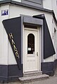
Barber shop in H 7: Haar Sieben

H 7 with a view of the Liebfrauenkirche


| Until 1733/ 1735 |
1735 - 1774 |
1774 Karg |
1774 - 1794 |
1794 - 1811 |
1811 - 1850 |
1850 - 1870 |
1870 - today |
Remarks |
|---|---|---|---|---|---|---|---|---|
| XXXIV | 44 | 43 | 41 | H 1 | H 1 | H 1 | H 1 | The houses facing the market square in G 2 and H 1 date from the time of the electorate and, together with the market square, town hall and St. Sebastian's Church, form an architectural unit. |
| XXXVII | 47 | 44 | 42 | H 2 | H 2 | H 2 | H 2 | |
| XLIV | 50 | 45 | 43 | H 3 | H 3 | H 3 | H 3 | |
| XLVII | 55 | 46 | 44 | H 4 | H 4 | H 4 | H 4 | The buildings in H 4 - as in J 5 and J 4 in the 1970s - were demolished in order to eliminate “unhealthy usage structures” .
Since 1982 the police station Mannheim-Innenstadt, also known locally as the “H4-Wache”, has been located in H 4, 1. Police station ”in F 1, 5 on the market square. |
| LV / LV½ | 58/59 | 47/48 | 45/47 | H 5 | H 5 | H 5 | H 5 | In H 5, 9 the "executioner's house" stood until the 1970s, the second oldest monument in the city center, which had to give way to a new building. |
| LVI | 60 | 49 | 46 | H 6 | H 6 | H 6 | H 6 | A large part of the square H 6 is taken by Swanseaplatz, which is named after Swansea , Mannheim's Welsh twin town . Several Wilhelminian-style houses had to give way to this somewhat neglected but largest children's playground in the city center. |
| - | - | - | - | - | - | H 7 | H 7 | In 1977, the H 7 square was declared a redevelopment area as part of the western lower town. In H 7, 1, the architect Theo Seiler created a modern commercial building that is an example of the reception of architecture from the 1950s in post-modern construction of the 1980s. |
I squares
In the Latin alphabet , there was no distinction between the sounds I and J for a long time, especially the capital letters were spelled the same in Germany until the 19th century and sometimes even longer. The capital I on the signs is not a J, there are no J (ot) squares. Non-residents are irritated by this spelling, as the following quote shows:
- “The squares go from A to U. J (Jot) does not exist. If someone says 'Jot five' instead of 'I five', the local laughs. Of course, Ä, Ö, Ü, ß are missing. "
Quoted from: Thomas Baumann: Square skull. A guide to Mannheim and the rest

I squares (yellow)

Road sign

Play street in I 3


| Until 1733/ 1735 |
1735 - 1774 |
1774 Plan Karg |
1774 - 1794 |
1794 - 1811 |
1811 - 1850 |
1850 - 1870 |
1870 - today |
Remarks |
|---|---|---|---|---|---|---|---|---|
| XXXV | 45 | 37 | 48 | I 1 | I 1 | I 1 | I 1 | Like K 1, I 1 belonged to the area of the former Neckartor, the largest of the three city gates, which was built in 1723. |
| XXXVI | 46 | 38 | 49 | I 2 | I 2 | I 2 | I 2 | |
| XLV / XLV½ |
52/ 51 |
39/ 40 |
50/ 53 |
I 3 / K 2 |
I 3 / K 2 |
I 3 / I 3 a |
I 3 | The "Schiefe Gasse", which cut I 3 and I 4 diagonally, created triangular squares, which were given the names I 3a and I 4a. |
| XLVI / XLVI½ |
54/ 53 |
41/ 42 |
51/ 52 |
I 4 / K 3 |
I 4 / K 3 | I 4 / I 4 a |
I 4 | The Central Institute for Mental Health , a renowned psychiatric clinic with an affiliated research institute, is located in I 4 and I 5 . The square I 4 was previously divided into I 4 and I 4a by an alley. The location within the Mannheimer squares was chosen to better integrate the patients into the social environment. The city administration linked the establishment of the institute with the goal of upgrading the western lower town. After the demolition of twenty houses, an eight-story high-rise was built that spans both squares, as the city planners tried to break up the structure of the city plan. |
| - | - | - | - | K 4 | K 4 | I 5 | I 5 | In 1970, in I 5, 6, the probably last examples of the typical Mannheim courtyard with wooden galleries were torn down. |
| - | - | - | - | - | - | I 6 | I 6 | As early as the 1920s, stationary and stationary traffic increased so much that options for relief were sought. In 1928 the Jungbusch garage, run by a private company, opened at I 6, 5, which was so unusual at the time that the local press thought it was worth mentioning:
|
| - | - | - | - | - | - | I 7 | I 7 |
K squares
The squares K and U did not yet exist at the time of the elector, because the walls of the fortress stretched over them. Even after the wall was razed in 1799, it took a long time for the first houses to be built here because the moat had not yet been filled in, which was a health risk on hot days. The first houses were built in the K-squares after 1850, namely in K 1 and K 4. The main part of the development took place between 1881 and 1890.

K squares (yellow)

Square K 5

Kurpfalzpassage with MVV customer center in K 1

City administration in K 7 with a view of the mosque


| Until 1733/ 1735 |
1735 - 1774 |
1774 Karg |
1774 - 1794 |
1794 - 1811 |
1811 - 1850 |
1850 - 1870 |
1870 - today |
Remarks |
|---|---|---|---|---|---|---|---|---|
| - | - | - | - | K 1 | K 1 | K 1 | K 1 | The Bernadushof is in K 1, 5–6. The Kurpfalzpassage runs through K 1, 7. The customer center of MVV GmbH , the Mannheimer Versorgungs- und Verkehrsgesellschaft mbH, was located here . The establishment of this customer and information center was seen as an opportunity to upgrade the north-western lower town and gave rise to the expansion of planning to build a representative residential and commercial building at the northern entrance to the inner city. The Mannheim architects Karl Schmucker and Andreas Plattner were entrusted with the design . In the post-war period, the Schauburg, a former cinema, was used as an alternative to the National Theater until the new building was ready for occupancy. |
| - | - | - | - | - | - | K 2 | K 2 | The former Jewish school was located in K 2, 6. In K 2, in the corner of a protruding bastion, there used to be a Catholic cemetery. |
| - | - | - | - | - | - | K 3 | K 3 | |
| - | - | - | - | - | - | K 4 | K 4 | |
| - | - | - | - | - | - | K 5 | K 5 | In K 5, in a three-storey listed old building, the Johannes Kepler School is located in the middle of a multicultural district. The "Pestbuckel" ran over from K 5 to Weststadt. When the plague broke out in 1666, the dead were buried here in a mass grave. Friedrich Engelhorn later built a gas factory on this plague hump in 1848. |
| - | - | - | - | - | - | K 6 | K 6 | |
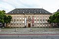
| - | - | - | - | - | - | - | K 7 | The regulatory office of the Mannheim city administration is located in K 7 in the former administration building of the water, gas and electricity works . The administration of the municipal water, gas and electricity works was set up in 1922–1926 and described in the Neue Mannheimer Zeitung of October 19, 1929 as a worthy representative of a large municipal company that takes into account all legitimate needs in terms of space and interior fittings.
Like U 6, K 7 is one of the two squares that do not have four corners, but a triangular shape. |
From the castle to the planks (right)
The squares between the castle and the planks (right) form the south-eastern inner city quadrant of the Ostliche Oberstadt district (L – O), the L squares south of Bismarckstrasse are in the castle area district (L 5–15).
L squares
The L-squares are located in the southeast of the inner city on both sides of Bismarckstrasse and are therefore the only squares that extend beyond the inner city ring. From L 4 only the squares with even numbers are north of Bismarckstrasse on the inner city side, those with odd numbers south of it and reach at the main station to L 15. They clearly exceed the numbering of the other squares.
Originally there was only one row of L-squares up to and including L 6 (at that time still called L 5), which until 1893 was partly built over at an angle with the stables of the dragoon barracks. The grand ducal tree nursery gardens followed in the direction of the Kaiserring. In connection with the construction of Bismarckstrasse through the nursery gardens, these were also parceled out after 1880 and the development of the new squares began. Initially they were coveted as a residential area, but after a few years Bismarckstraße was extended along the castle as planned and quickly developed into a busy street.

L squares (yellow)
L 1 with a view of the Mannheim Castle

Main service building of the police headquarters in L 6

University building in L 7

ZEW in L 7


| Until 1733/ 1735 |
1735 - 1774 |
1774 Karg |
1774 - 1794 |
1794 - 1811 |
1811 - 1850 |
1850 - 1870 |
1870 - today |
Remarks |
|---|---|---|---|---|---|---|---|---|
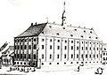
| DD | 103 | 94 | A 5 | A 5 | L 1 | L 1 | L 1 | In L 1 opposite the castle stood the monastery church of the Augustinian women who taught girls here. The monastery was later converted into a primary school. The city history collections were housed here from 1905 to the 1920s. The Rhein-Neckar Chamber of Commerce and Industry has its seat in L 1, 2. |
| CC | 102 | 95 | A 6 | A 6 | L 2 | L 2 | L 2 | Johann Baptist Lingg von Linggenfeld and his family lived in house L 2, 2 from 1821 until his death in 1842. He bought the house in 1833 from Captain Baron von Beidenfeld for 9500 guilders. 1842 it went at auction for 11,850 florins to the Lord Partikulier sneeze. Today this building belongs to the university (international meeting center for science). |
| BB | 101 | 96 | A 7 | A 7 | L 3 | L 3 | L 3 | The Carmelite monastery with a church was located in L 3. In total, there were four churches opposite the castle: the Jesuit Church, the Sodality Church, the Nuns Church and the Carmelite Church. Today the tax office is at this point. |
| AA | 100 | 97 | A 8 | A 8 | L 4 | L 4 | L 4 | In L 4, 4 stood the Düringersche Palais, the residential and commercial building of the cooper Heinrich Düringer. After the building was sold in 1919, the building fell into disrepair and in the 1950s had to give way to the functionalist new building of the labor court , which is now located at E 7. Heinrich Vögele had the existing corner house L 4, 15 built for investment. There was one apartment per floor with twelve rooms and high-quality furnishings, including an elevator with electrical control, central heating and a garbage disposal . |
| - | - | - | - | - | - | - | L 5 | The square L 5 is - south of Bismarckstrasse adjoining the east wing of Mannheim Palace - the narrowest of the L squares. The castle dungeons were located there until 1893, and were demolished in connection with the construction of Bismarckstrasse. The square was built on with villas after 1900 and was largely spared from destruction in the Second World War. University facilities can be found there. L 5, 1 is also known as the “Marketing Villa”, as Germany's most renowned university chairs for marketing are located here. In L 5, 2 is the villa of the factory owner Consul Alois Bender. The villa of the manufacturer Paul Giulini is in L 5, 3 . In L 5, 4 is the villa of banker Adolph Goldmann, in L 5, 5 the villa of civil servant Georg Gelb. The end of the villas is the neo-Gothic villa of the industrialist Heinrich Vögele in L 5, 6. |
| YY | 99 | 98 | A 9 | A 9 | L 5 | L 5 | L 6 | The Mannheim police headquarters are located in L 6, and the main service building in L 6, 1, which was built in 1903 as the Badisches Bezirksamt and has been used as a police headquarters since 1938. In 1828 the stables of the dragoon barracks were built, running diagonally across part of the square, which were located next door in M 3 a and M 4 a. The stables were demolished again in the summer of 1893. As a result, L 6, which until then had approximately the shape of a triangle, was given its rectangular shape. |
| - | - | - | - | - | - | - | L 7 | L 7, 1, the Center for European Economic Research (ZEW), one of the leading economic research institutes in Germany, his seat. He specializes in the micro-economic and micro- econometric research, particularly internationally comparative issues. The disposal building of the University of Mannheim is located in L 7, 3–5 on the corner of Bismarckstraße. At the site of the ZEW, the probably most important and most elaborate villa of the L-squares once stood. The banker Gustav Ladenburg (1847–1902), co-owner of the Ladenburg bank , had secured the southern half of the square by buying up six plots and had a sophisticated Renaissance-style villa built with a large garden area for over 350,000 marks in 1884/85. |
| - | - | - | - | - | - | - | L 8 | L 8 was only established at the end of the 19th century. Before that, from 1828 onwards, the dragoon stables, which were demolished in 1893 for the construction of Bismarckstrasse, ran diagonally across the L 6 towards the castle. The recessed corner to the square M 5 at L 8, 4 and L 8, 5 still reminds of the former course of the building front. |
| - | - | - | - | - | - | - | L 9 | L 9 was planned as a villa area towards the end of the 19th century and was acquired by Friedrich Engelhorn as a whole. Until 1890 he gradually sold the parcels to solvent interested parties, who in turn had the goal of building them profitably and reselling them. For example, Heinrich Lanz is said to have owned property L 9, 10 in 1892. The villa of the banker Wilhelm Maast in L 9, 4-5 is still preserved. The Mannheim Logenhaus is located in L 9, 9 . |
| - | - | - | - | - | - | - | L 10 | L 10 was created with the development of the former tree nursery gardens. From that time there is still the villa built in 1892 in L 10, 1 on Bismarckstrasse by Dr. Felix Hecht, which, compared to other villas in the L-squares, was designed very cautiously and dispensed with decorative details. |
| - | - | - | - | - | - | - | L 11 | L 11, also located in the former tree nursery gardens, was - in contrast to the squares L 5 to L 9 in the same row - no longer oriented primarily towards villas, but rather laid out in smaller plots. The two still preserved houses in L 11, 7 and L 11, 8 give an impression of the former streets. |
| - | - | - | - | - | - | - | L 12 | Established only after 1900. |
| - | - | - | - | - | - | - | L 13 | Established only after 1900 south of Bismarckstrasse. |
| - | - | - | - | - | - | - | L 14 | Established only after 1900. |
| - | - | - | - | - | - | - | L 15 | L 15 was only set up after 1900 south of Bismarckstrasse on the station forecourt. It is the Mannheim square with the highest number. It is dominated by the office building L 15, 1-6 on the Suez Canal , which the state of Baden-Württemberg bought from Hamburg-Mannheimer Versicherung at the end of 2002 and which houses the facilities of the University of Mannheim. The building complex adjoining the main train station is no longer part of L 15, but belongs to Willy-Brandt-Platz. |
M squares
Between 1722 and 1723, Elector Karl Philipp had the Belderbusch barracks built here, which was named Dragoon Barracks after the transition to Baden. During the period of passive resistance against France, the barracks were a reception camp for deportees, mostly railway workers. At the same time, the Ludwigshafen Railway Directorate was housed here. In the Third Reich, part of the dragoon barracks was rebuilt and used as the headquarters of the SA .

M squares (yellow)

Employment agency in M 3a
Remains of the St. Andreas bastion

Kurpfalzgymnasium


| Until 1733/ 1735 |
1735 - 1774 |
1774 Karg |
1774 - 1794 |
1794 - 1811 |
1811 - 1850 |
1850 - 1870 |
1870 - today |
Remarks |
|---|---|---|---|---|---|---|---|---|
| V | 93 | 89 | 79 | B 6 | M 1 | M 1 | M 1 | Karl von Drais , the inventor of the balance bike , lived in M 1, 8 . This was the start and end point of his test drive on June 12, 1817 to the relay house on the Chaussee in Schwetzingen. The square M 1 is also called the “church square” because most of the buildings are owned by the church. In addition to rented residential and commercial space, the central facility of the Evangelical Church in Mannheim, the “House of the Church” (with the deanery, church administration office, etc.) is located here. For a time, M 1, 8 housed the old music academy founded in 1899 . Constanze Weber, who later became Mozart's wife , lived in M 1, 10 with her family. |
| T | 92 | 90 | 80 | B 7 | M 2 | M 2 | M 2 | In M 2, 17, the first location of the Rheinische Porzellanfabrik Mannheim , is the former home of the Jewish Steiner family. |
| S. | 91 | 91 | 81 | B 8 | M 3 | M 3 / M 3 a |
M 3 / M 3a |
The square M 3 is divided into M 3 and M 3a by a cross street. The administration of the employment office and the career information center are located in M 3a . A barracks was built on M 3a and M 4a in 1722 for the electoral guardsmen, which was taken over by the 2nd Badischer Dragoon Regiment at the beginning of the 19th century and demolished in 1930/1932. |
| R. | 90 | 92 | 82 | B 9 | M 4 | M 4 / M 4 a |
M 4 / M 4a |
Karl von Drais lived in M 4, 9 until 1839. From 1722 to 1930/1932 a part of the dragoon barracks was located on the M 4a square, cf. M 3a. |
| KK | 89 | 93 | 83 | B 10 | M 5 | M 5 | M 5 | The head office of the trade association for trade and goods distribution is located in M 5, 7 . |
| - | - | - | - | - | - | - | M 6 | The M 6 square is shared by the Lauer Gardens and the Kurpfalzgymnasium . On March 28, 1945 - one day before the city was handed over to US troops - four employees of the Velvet and Silk Company were shot dead in this facility for raising a white flag. The last remaining aboveground part of the Mannheim fortifications is in the Lauer Gardens, the St. Andreas Bastion, which stretched across today's L 8 and L 6 squares towards the castle. |
| - | - | - | - | - | - | - | M 7 | The former central bank is in M 7, 3–6 . During his career, the architect designed around 90 branch buildings for the Reichsbank , often taking up local building traditions. The main feature of the three-storey building is the shell limestone clad facade. Striking details are the stone reliefs created by the Berlin sculptor August Vogel , which show putti , which allude to the commercial qualities of loyalty, diligence, vigilance and wealth. |
N squares
The Art Street lies between the N and O squares. However, this is only an unofficial name. The music and art dealers Sohler, Donnedker, Hasdenteufel and Heckel were located here. Emil Heckel, a friend of Richard Wagner's , had the first Wagner bust in Germany unveiled here in 1887.

N squares (yellow)
Town house N 1

Parking garage in N 2


| Until 1733/ 1735 |
1735 - 1774 |
1774 Karg |
1774 - 1794 |
1794 - 1811 |
1811 - 1850 |
1850 - 1870 |
1870 - today |
Remarks |
|---|---|---|---|---|---|---|---|---|
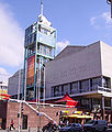
| M. | 22nd | 18th | 18th | C 9 | N 1 | N 1 | N 1 | The Mannheim town house occupies the square N 1, in a central location of the city . The dominant motif of the town house is the central tower with its open steel construction and a glass elevator shaft that leads to a café on the top floor. |
| L. | 15th | 19th | 19th | C 10 | N 2 | N 2 | N 2 | Right next to the town house is a remarkable parking garage, which in 1967 was one of the most advanced of its time. The cars drive on two opposite one-way streets over ceilings that form inclined levels with a gradient of 4 percent and serve as ramps for entry and exit. |
| K | 14th | 20th | 20th | C 11 | N 3 | N 3 | N 3 | The director of the Mannheim National Theater, Freiherr Wolfgang Heribert von Dalberg , lived in Dalberg's house in N 3, 4 . Today the music and children's department of the city library is located in this building. |
| J | 7th | - | 21st | C 12 | N 4 | N 4 | N 4 | The area of the northeast corner of the square N 4 is the Kapuzinerplatz , also called "Gockelsmarkt" (Gockel = pine cone), with a statue of St. John Nepomuk (replica), the original of which was created by Paul Egell . Originally the Blumepeter monument was also erected on Kapuzinerplatz, but was later moved to the Kapuzinerplanken in O 5. |
| - | 23 | - | - | C 13 | N 5 | N 5 | N 5 | The square N 5 is one of those areas, the development of which changed several times. In the 18th century there was a Capuchin monastery here, the monastery garden of which has been preserved as the "Scipio garden" and later belonged to the late Classicist villa of the merchant and private scholar Wilhelm Scipio . N 5, 6–7 is the location of the Engelhorn sports store. |
| I. | 25th | - | - | C 14 | - | N 6 | N 6 | In November 2012, the car park N 6 was named the worst car park in Germany in a test by the ADAC . The parking spaces are only 2.17 meters wide. Driveway, ramps and lane are too narrow. The parking spaces are lined with pillars and there is no lighting. There is only one parking space for the disabled. |
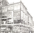
| - | - | - | - | - | - | N 7 | N 7 | Mannheim's largest cinema, the postmodern CinemaxX , is located in N 7, 17 , a spectacular new cinema building. Immediately afterwards in N 7, 18 is the former Siemenshaus, today's Mannheim University of Music and Performing Arts . The main work of New Objectivity was the department store of Berlin Samt & Silk and Terra AG in N 7 from 1927 to 1930, which was created by the Frankfurt architect Fritz Nathan , the first high-rise in Mannheim. |
O squares
The planks , the most important shopping street in the shopping city of Mannheim, run between the O and P squares . The southern parts of the squares O 5 and O 6 form the " Kapuzinerplanken ".

O squares (yellow)

Paradeplatz with town house

Former post office in O 2

Paradeplatz and planks


| Until 1733/ 1735 |
1735 - 1774 |
1774 Karg |
1774 - 1794 |
1794 - 1811 |
1811 - 1850 |
1850 - 1870 |
1870 - today |
Remarks |
|---|---|---|---|---|---|---|---|---|
| D. | 21st | - | - | D 7 | O 1 | O 1 | O 1 | The Mannheimer Paradeplatz occupies a central position in the city. It takes its name from the historical fact that it was used for troop deployment during the times of the electors. In the middle of the square is the Grupello pyramid , erected in 1743 , which was originally created in the Düsseldorf palace garden and in 1711 by Gabriel de Grupello for the elector Johann Wilhelm . The bronze pyramid has the name Allegory of the ruling virtues and represents the triumph of the princely virtues. The parade ground was a fallow area after the Second World War and, including the fountain, was not reconstructed until the turn of the century in the early 1990s. |
| C. | 16 | 13 | 13 | D 8 | O 2 | O 2 | O 2 | Right next to Paradeplatz in O 2, 1–10 is the post office, which was praised when it was inaugurated in 1957 as a building "of objectivity, but also of exhilaration" . The old post office, which was destroyed in the Second World War from 1880 to 1882, was a neo-renaissance building that occupied the northern part of the O 2 square, with the main facade on the planks . The new building takes up the entire O 2 square and faces the Paradeplatz. |
| B. | 13 | 14th | 14th | D 9 | O 3 | O 3 | O 3 | In O 3, 6–7, the Hirschland department store, which was destroyed in the Second World War, was opened by Albert Friedrich Speer senior in 1914–1917 . When the reinforced concrete structure was designed in such a way that the 800 square meter and 7.5 meter high sales hall on the ground floor could be built without internal supports. On the planks in O 3, 10 was the instrument and music shop of Karl Ferdinand Heckel , whose son, Emil Heckel, was an ardent Wagner fanatic who founded the first Wagner club in Germany in 1871 and supported the Bayreuth Festival at great expense a. |
| A. | 8th | 15th | 15th | D 10 | O 4 | O 4 | O 4 | In O 4, 3 stood the magnificent house of the architect Johann Jakob Rischer , which attracted attention with its lavish sculptural decoration. His house was passed on to the court chamberlain Wrede in 1763 and stood until 1905. The ice cream parlor is located in O 4, 5, from which the invention of spaghetti ice cream originates. |
| XI | 6th | 16 | 16 | D 11 | O 5 | O 5 | O 5 | During the renovation of the Engelhorn & Sturm clothing company , which was built in 1902–1903 in O 5, 4–5, a corner lot on the planks, the facade was completely freed from its historic decor in 1927–1928 and the helmet of the Bayers eliminated. The walls, which had been freed from architectural decorations, offered new possibilities for advertising slogans, so that advertising as a design element increasingly came to the fore. The place on the southern part of the squares O 5 and O 6 is called "Kapuzinerplanken". |
| II | 1 | 17th | 17th | D 12 | O 6 | O 6 | O 6 | Between O 6 and O 7, at that time still outside the city, the scaffold was built in 1820 on which Karl Ludwig Sand was beheaded, who murdered the Russian State Councilor August von Kotzebue on March 23, 1819 in A 2 . In O 6, 3 the aluminum facade of the former Engelhardt carpet store is striking, which was recognized as an “elegant accent on the planks” at the inauguration. Today it is an example of facade art from the 1960s. The Wempe office building is at O 6, 7. The place on the southern part of the squares O 5 and O 6 is called "Kapuzinerplanken". |
| - | - | - | - | - | - | O 7 | O 7 |
From the planks to the Neckar (right)
The squares between the planks and the Neckar (right) form the northeastern inner city quadrant of the city district of Eastern Lower Town (P – U).
P-squares
The Mannheimer Planken, Mannheim's main shopping street, run in front of the P-squares.
The street between P and Q has the unofficial name "Fressgasse" and was formerly called Pfälzer Straße.
P-squares (yellow)
View of the Mannheim water tower

Memorial sculpture glass cube in front of P 2


| Until 1733/ 1735 |
1735 - 1774 |
1774 Karg |
1774 - 1794 |
1794 - 1811 |
1811 - 1850 |
1850 - 1870 |
1870 - today |
Remarks |
|---|---|---|---|---|---|---|---|---|
| XXXI | 20th | 7th | 7th | E 8 | P 1 | P 1 | P 1 | At P 1, 10, where the Kaufhof is today, there used to be the Schmoller department store, which was founded by Jewish merchants. After expansion in 1911 and 1927, the company was Aryanized in 1938 and was called Ernst Vollmer & Co. from then on. After the war, it was operated as an Anker Kaufstätte (subsidiary of Kaufhof) from 1953, and renamed Kaufhof in 1968. |
| XXII | 17th | 8th | 8th | E 9 | P 2 | P 2 | P 2 | On the planks in front of P 2, in the form of a transparent cube, there is a memorial sculpture for the Jewish victims of National Socialism in Mannheim, designed by the Freiburg artist Jochen Kitzbihler . |
| XXI | 12 | 9 | 9 | E 10 | P 3 | P 3 | P 3 | In addition to the Dresdner Bank , the war ruins of another bank were located here after 1945: Commerz- und Privatbank AG Hamburg-Berlin. The new building in P 3, 1–2 was regarded as a model for a modern commercial building. The six-storey cubic building expresses objectivity and functionality, but still has a representative claim, which is already evident from the fact that it is clad with travertine . |
| XII | 9 | 10 | 10 | E 11 | P 4 | P 4 | P 4 | At P 4 there was the end of the plank, where the walkway was built over by the arcades over a length of thirty meters. Since 1921, the Mannheim headquarters of the General German Trade Union Confederation was located in P 4, 4–6. The occupation of the building in 1933 symbolized the smashing of the Mannheim trade union movement by the National Socialists. In the early 1990s, number 13 was also home to the pioneering breakbeat club Milk! . Today "P4, 4" is known primarily in the student club scene as a hotspot for underground parties. |
| X | 5 | 11 | 11 | E 12 | P 5 | P 5 | P 5 | The widening of the planks in the 1930s gave rise to an important new building project. In P 5, 1–4 was the "Defaka". In order to promote the expansion of the commercial street, the city decided to build a department store as a branch of the German family department store and an office building with a shopping arcade in the vacated squares P 5 and P 6. The building complex in P 5 is noticeable in that its south-west corner is emphasized by a building that protrudes into the street and is one storey higher. This is an indication of the point where the “narrow planks” formerly ended. |
| III | 2 | 12 | 12 | E 13 | P 6 | P 6 | P 6 | The squares P 5 and P 6 protruded into the street and formed the “narrow planks” until the 1930s. The Plankenhof in P 6 is a strict cubic structure that was created when the planks were breached in 1936. The purchase of the corner house P 6, 20 was rejected in 1911 on the grounds that the plank breakthrough was "to be left to private initiative" . |
| - | - | - | - | - | - | P 7 | P 7 | In P 7, 5-7 between the planks and the Fressgasse, the ÖVA-Passage was established between 1955 and 1957. It got its name from the former administration building of the public insurance company of the Badische Sparkassen (ÖVA, today: SV SparkassenVersicherung ). It runs in two arms that lead in a curve through the building and meet at Fressgasse. Another passage between Planken and Fressgasse is the Kurfürsten-Passage in P 7, 24. |
Q squares
Q squares (yellow)
Breeding, madhouse and orphanage

Q 4, 11


| Until 1733/ 1735 |
1735 - 1774 |
1774 Karg |
1774 - 1794 |
1794 - 1811 |
1811 - 1850 |
1850 - 1870 |
1870 - today |
Remarks |
|---|---|---|---|---|---|---|---|---|
| XXX | 19th | 1 | 1 | F 8 | Q 1 | Q 1 | Q 1 | |
| XXIII | 18th | 2 | 2 | F 9 | Q 2 | Q 2 | Q 2 | In a report on the Reichspogromnacht , the Mannheim local press wrote on November 9, 1938:
- Quoted from a facsimile in: Remember. Reich pogrom in Mannheim in November 1938. Mannheim 1988
|
| XX | 11 | 3 | 3 | F 10 | Q 3 | Q 3 | Q 3 | |
| XIII | 10 | 4th | 4th | F 11 | Q 4 | Q 4 | Q 4 | In Q 4, 11 the Habereckl brewery was founded in 1776, which built a new storage cellar with a capacity of 4,000 hectoliters here in 1933 and built a new brewhouse in the inner courtyard from 1936–1937, which was a 42-meter-high tower due to the limited space available was executed. This Habereckl tower was demolished in 1984 after the brewery had been taken over by Binding two years earlier and production in Mannheim had ceased. |
| IX | 4th | 5 | 5 | F 12 | Q 5 | Q 5 | Q 5 | |
| IV | 3 | 6th | 6th | F 13 | Q 6 | Q 6 | Q 6 | In Q 6 was the state prison, which was founded in 1749 under Elector Karl Theodor as a Mannheim kennel, madhouse and orphanage . Not only criminals were imprisoned in this prison, but also the mentally ill and orphans. The penitentiary doctor at the time wrote about the conditions in the area. FA May:
The development of Q 6 as a whole as well as the adjacent large parts of Q 7 were demolished in 2012/2013 to make way for a shopping mall called “Stadtquartier Q 6 Q 7”, which opened in autumn 2016. |
| - | 24 | - | - | - | - | Q 7 | Q 7 | In Q 7, 10 the small Elisabethbad was a public bath with swimming pool. It was one of six public baths that the city of Mannheim had set up as welfare institutions for the working population. |
R squares

R squares (yellow)

Former Mannheim Evening Academy in R 3
Central tower of the Konkordienkirche


| Until 1733/ 1735 |
1735 - 1774 |
1774 Karg |
1774 - 1794 |
1794 - 1811 |
1811 - 1850 |
1850 - 1870 |
1870 - today |
Remarks |
|---|---|---|---|---|---|---|---|---|
| XXIX | 42 | 31 | 22nd | G 7 | R 1 | R 1 | R 1 | Elector Karl Philipp moved into house R 1, 1, the so-called casino building, on November 14, 1720 , after he had left Heidelberg and moved the residence to Mannheim. The Prussian King Friedrich Wilhelm I lived in this house on August 6, 1730 with his son, who later became Friedrich the Great . Shortly before, a page had told the king of the Crown Prince's attempted escape the day before. The successor to the classicist Palais Bassermann in R 1, 4–6, which was destroyed in the Second World War, became the Mannheimer Morgen publishing house in 1958, with a white perforated facade that contrasts with the historical development. |
| XXIV | 36 | - | - | G 8 | R 2 | R 2 | R 2 | In R 2, 1–2 is the Konkordienkirche , a former double church with a central tower facade , the second half of which is now occupied by the Mozart School. |
| XIX | 35 | 32 | 23 | G 9 | R 3 | R 3 | R 3 | The Mannheim Evening Academy was in R 3, 13–15 until she moved to U 1 in 2009 . |
| XIV | 29 | 33 | 24 | G 10 | R 4 | R 4 | R 4 | |
| VIII | 28 | 34 | 25th | G 11 | R 5 | R 5 | R 5 | The Institute for German Language (IDS) is located in R 5, 6–13 . The Institute for German Language is a foundation under civil law that is dedicated to language research. The aim is to scientifically research and document the German language in its current use and in its recent history. In the new building at the beginning of the 1990s, the parts of the general hospital that were still preserved at that time were integrated into the current building. |
| V | 26th | 35 | 26th | G 12 | R 6 | R 6 | R 6 | The sloping streets at R 6 indicate the former course of the fortress walls. Here you come across fortress remains during construction work. |
| - | - | - | - | - | - | R 7 | R 7 | The Lamey Garden takes up part of the R 7 square. The garden is named after Andreas Lamey , who, together with Maillot de la Treille, ran a library with around 70,000 volumes, the use of which was open to everyone. In this square, the Mannheim architects Ferdinand and Heinrich Mündel built a residential high-rise between 1955 and 1957 on behalf of the Mannheim savings and construction association. |
S squares

S squares (yellow)

Residential houses in S 5

Supermarkets and apartment buildings

Weltladen in S 2


| Until 1733/ 1735 |
1735 - 1774 |
1774 Karg |
1774 - 1794 |
1794 - 1811 |
1811 - 1850 |
1850 - 1870 |
1870 - today |
Remarks |
|---|---|---|---|---|---|---|---|---|
| XXVIII | 41 | 27 | H 7 | H 7 | S 1 | S 1 | S 1 | |
| XXV | 37 | 28 | H 8 | H 8 | S 2 | S 2 | S 2 | |
| XVIII | 34 | 29 | H 9 | H 9 | S 3 | S 3 | S 3 | After being moved from N 6, S 3 was home to the asylum for women who had recently given birth and had such a bad reputation that it was called "Hell". From this asylum for women who had recently given birth, the gynecological clinic of the University of Heidelberg emerged after the transfer to Heidelberg in 1805 . The Mannheim workers' secretariat , founded in 1899, had its seat in a two-room apartment in S 3, 10. It was set up to prevent fragmentation among the unions , because in 1904 there were 41 trade union professional organizations in the city. In 1922 the Mannheim local cartel had over 40,000 members and so the ADGB moved to a former inn in P 4, 4–5. |
| XV | 30th | 30th | H 10 | H 10 | S 4 | S 4 | S 4 | The residential complexes of the non-profit construction company in S 4 / S 5 were created as parallel lines. In 1914, the renowned trade journal Deutsche Bauhütte referred to several new buildings in Mannheim, including the apartment building in S 4 designed by the architects Batz & Baumüller. The four-storey building with its sandstone facade was seen as proof of the efforts of the local architects for good design. |
| VI | 27 | 36 | - | H 11 | H 11 | S 5 | S 5 | |
| - | - | - | - | - | - | S 6 | S 6 |
T squares

T-squares (yellow)
"Glass Palace"
T 1

Memory of the first automobile in T 6, 33


| Until 1733/ 1735 |
1735 - 1774 |
1774 Karg |
1774 - 1794 |
1794 - 1811 |
1811 - 1850 |
1850 - 1870 |
1870 - today |
Remarks |
|---|---|---|---|---|---|---|---|---|
| XXVII | 40 | 22nd | 31 | J 5 | T 1 | T 1 | T 1 | In house T 1, 1 was the restaurant Zum silbernen Anker , where Johann Philipp Zeller founded the Mannheim antiquity association in 1859 . Its holdings formed the basic holdings of the later tearing museum . In 1900, the Kander department store, the first department store in Mannheim, was founded at the same location . It was nicknamed the "Glass Palace" because the walls were almost entirely made of glass. From 1990 on, T 1, 1–3 was the media house Prinz , a symbiosis between bookstore and media experience house of the Hamburg Ganske publishing group with sound carriers and software, which was released in 2001 due to the poor sales situation - against considerable resistance from the 86-strong workforce. has been closed. |
| XXVI | 38 | 23 | 32 | J 6 | T 2 | T 2 | T 2 | |
| XVII | 32 | 25th | 33 | J 7 | T 3 | T 1 | T 3 | |
| XVI | 31 | 26th | 34 | J 8 | T 4 | T 4 | T 4 | The originally only small area was located with a strongly sloping northeast side on a curtain wall of the city fortifications and could only be added to a rectangle after the fortress was removed in the 19th century. The "Kleine Wallgasse" along the former slope was preserved by the "square" until the Second World War. The complete square T 4 is currently fallow. Here was part of the former Sickingerschule, a secondary school with a technical secondary school . This was demolished starting in 2012. The new building is already well advanced (as of June 2018). |
| - | - | - | - | - | - | T 5 | T 5 | T 5 was not built until around 1865, some time after the city fortifications had been removed, in the area of the former St. Simon bastion. Here was the second part of the former Sicking School. The new development has started. |
| - | - | - | - | - | - | T 6 | T 6 | Carl Benz built his first automobile on property T 6, 11 (today T 6, 33) . Together with the mechanic August Ritter, he bought the property with a wooden shed in 1871 and named the company Carl Benz and August Ritter, mechanical workshops . |
U squares

U-squares (yellow)
Herschelbad in U 3
Eberhard Gothein School in U 2
Former, first hardware store in Germany in U 3


| Until 1733/ 1735 |
1735 - 1774 |
1774 Karg |
1774 - 1794 |
1794 - 1811 |
1811 - 1850 |
1850 - 1870 |
1870 - today |
Remarks |
|---|---|---|---|---|---|---|---|---|
| - | - | - | - | K 5 | U 1 | U 1 | U 1 | The Mannheim Evening Academy is located in U 1, 16-19 , an educational institution with 50 permanent employees and over 1,200 freelance workers, which was founded in 1899 and can be equated with adult education centers in other cities. |
| XXVI½ | 39 | - | 35 | K 6 | U 2 | U 2 | U 2 | The former Friedrichsschule, now Eberhard-Gothein-Schule (the "U-Schule"), a vocational school, and the Maria-Montessori -School are located in U 2 . Eberhard Gothein was a cultural historian and economist who in 1904 took over Max Weber's chair for national economy in Heidelberg. The square between the two schools is called Herschelplatz after the founder of the Herschelbad in square U 3. |
| XVII½ | 33 | 24 | - | K 7 | U 3 | U 1 | U 3 | In 1905 the Mannheim city councilor Bernhard Herschel donated 500,000 marks for the construction of a bath, the so-called Herschel bath . The building construction department checked 13 building sites as possible locations before square U 3 became vacant in 1911 when the main fire station moved . The indoor swimming pool, designed in neo-baroque style, is one of the main works of Art Nouveau in Mannheim. However, due to the destruction in World War II and the lack of a faithful reconstruction, today's appearance is severely impaired.
In 1960 the first hardware store in Germany was opened in U 3, 21-22 . Today only the neon advertising of the Bauhaus company , whose German headquarters is still based in Mannheim, reminds of the former location. |
| - | - | - | - | - | - | U 4 | U 4 | |
| - | - | - | - | - | - | U 5 | U 5 | |
| - | - | - | - | - | - | U 6 | U 6 | U 6, like K 7, is one of the two squares that do not have four corners, but a triangular shape. |
Former squares outside the ring
In the second half of the 19th century, streets in the area of today's Jungbusch were also included in the numbering of squares. To the northwest of the city center, the blocks on the Neckar were named as Z-squares. Between the ring road and the newly built connecting canal, the numbers were simply continued beyond the ring. This resulted in C 9 to F 8 and G 8 to G 12. In 1891, the Z squares and the squares from G 9 were included in the system from H to K and H 8 to H 12, J 8 to J 10 and K 8 to K 10. The square names Z 9 and Z 10 were temporarily used in the Lindenhof area near the main train station. At the end of the 19th century the names of squares outside the ring were finally abolished.
reception
Some institutions in Mannheim's city center approach their names onomatopoeically to the square of their location, for example the "Sea Five" spoken restaurant in C 5, the ZEPHYR branch of the Reiss-Engelhorn museums in C 4 or Haar 7 , the barber shop in H 7th
The Manhattan metric is also known as the "Mannheim metric".
The team of the inline hockey club ISC Mannheim is called "quadRats"
literature
- Valentin Schmitt: The Mannheim squares are uneven and lovable . Mannheimer Verlagsanstalt, Mannheim 1976, ISBN 3-87804-041-5 .
- Thomas Baumann : square skull. A guide to Mannheim and the rest . Hermann-Josef Emons Verlag, 2005, ISBN 3-89705-412-4 (on the subject of “squares”: pp. 13, 80, 138, 232).
- Andreas Schenk: Architectural Guide Mannheim . Dietrich Reimer Verlag, Berlin 1999, ISBN 3-496-01201-3 .
- Landesdenkmalamt Baden-Württemberg : The art monuments of the city district of Mannheim . Deutscher Kunstverlag, Munich 1982, ISBN 3-422-00556-0 (on the subject of “squares”: pp. 85–92).
Web links
A thematic collection of articles about the city can be found on the Mannheim portal .
Individual evidence
- ↑ Feder von, Heinrich [arr.]: History of the city of Mannheim according to the sources (Volume 1). City map from 1663. In: Heidelberg historical holdings - digital. Heidelberg University Library, p. 50/51 , accessed on August 4, 2015 .
- ↑ Chronicle Star. MARCHIVUM , August 15, 1865, accessed September 27, 2018 .
- ↑ Chronicle Star. MARCHIVUM, August 15, 1865, accessed September 27, 2018 .
- ↑ Beatrice Oßberger: Pawnbrokers: When the bank says no . In: THE WORLD . March 11, 2018 ( welt.de [accessed May 13, 2020]).
- ↑ Astrid Hansen: "In order to do justice to all people, it is an art that nobody can". On the repair of a Wilhelminian-style bank building in Mannheim, E 3, 16. In: Denkmalpflege in Baden-Württemberg, BD 32, No. 4 (2003), pp. 332–337 (PDF 748 kB).
- ^ City of Mannheim: Plank breakthrough and new town hall building. Retrieved January 27, 2015 .
- ↑ Chronicle Star. MARCHIVUM, May 21, 1981, accessed September 27, 2018 .
- ↑ a b Dragoon barracks. (PDF 455 kB) MARCHIVUM, accessed on May 19, 2018 .
- ↑ Chronicle Star. MARCHIVUM, July 3, 1893, accessed September 27, 2018 .
- ↑ a b Ferdinand Werner , Andreas Schenk: Mannheimer Villen: Architektur und Wohnkultur in den Quadrats und der Oststadt , Wernersche Verlagsgesellschaft, Worms, 2009, ISBN 978-3-88462-289-6 , p. 83 ff. ( Limited preview in the Google Book Search).
- ↑ MARCHIVUM: Mannheimer street names, Palatine Road. Retrieved September 17, 2018 .
- ↑ Mannheim city plans in the Baden-Württemberg State Archives, Mannheim around 1870 , Mannheim 1895 , Lindenhof 1874 and others
- ↑ Chronicle Star , MARCHIVUM, January 1st, 1899 accessed May 13, 2020th
Coordinates: 49 ° 29 ' N , 8 ° 28' E