
Karksi
| Karksi | |||
|
|||
| State : |
|
||
| Circle : |
|
||
| Coordinates : | 58 ° 7 ' N , 25 ° 35' E | ||
| Area : | 266.4 km² | ||
| Residents : | 4,022 (2010) | ||
| Population density : | 15 inhabitants per km² | ||
| Time zone : | EET (UTC + 2) | ||
| Telephone code : | (+372) 322.3 | ||
| Community type: | former rural community | ||
| Website : | |||

|
|||


Karksi (German: Karkus ) is a former rural community in the Estonian district of Viljandi with an area of 322.29 km². It had 4022 inhabitants (as of January 1, 2010). On October 24, 2017, the rural parishes of Karksi, Abja , Halliste and the small town of Mõisaküla were merged to form the new rural municipality Mulgi .
In addition to the town of Karksi-Nuia (2059 inhabitants, Nuia until 1987), the rural community included the villages of Äriküla, Ainja, Allaste, Hirmuküla, Karksi, Kõvaküla, Leeli, Lilli, Metsaküla, Morna, Muri, Mäeküla, Oti, Polli, Pärsi, Pärsi , Sudiste, Suuga, Tuhalaane and Univere.
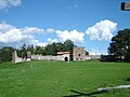
Karksi was first mentioned in a document in 1241. In the 13th century the parish and the castle emerged. The Peetri Church of Karksi with its distinctive tower was built in 1787 on a side wall of the castle, which was lost in 1708. The current mansion of Karksi was built in the 18th century in the early classical style.
Ordensburg Karkus


Karksi was first mentioned in a document in 1241. Karkus Castle was built in the 13th century . On a side wall of the castle of the Teutonic Order , which was destroyed in 1708, the Peetri Church of Karksi with its striking tower was built in 1787. Today the castle is in ruins.

Karkus Castle, 1

Karkus Castle, 2

Karkus Castle, 3

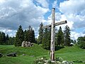
Castle hill in Karksi

Karkus Castle, 4

Karkus Castle, 5

Karkus Castle, 6

Karkus Castle, 7

Karkus Castle, 8

Karkus Castle, 9

Karkus Castle, 10
Karkus Castle, 11

Karkus Castle, 12
Karkus Castle, 13

Karkus Castle, 14

Karkus castle ruins with attached village church

"Ruins of the Karkus Castle", 1797, Johann Christoph Brotze's book Collection of various Lieland monuments

"Prospect at the ruins of Karkus in the year 1800", Johann Christoph Brotze's book collection of various Liefland monuments

"Ruins of the Karkus Castle", 1796, Johann Christoph Brotze's book Collection of various Lieland monuments

"Prospect of the ruins of Karkus Castle, next to the church. In the distance you can see Gut Pollenhof", 1792, Johann Christoph Brotze's book collection of various Liefland monuments

"Prospect of the church from Karkus and the ruins of the castle formerly located there", 1785, Johann Christoph Brotze's book collection of various Lieland monuments


Web links
- Karksi Municipality website (Estonian, English and Russian)