Kent Island (Western Australia)
| Kent Island | ||
|---|---|---|
| Waters | Scambridge Gulf , Pentecost River | |
| Geographical location | 15 ° 9 ′ S , 128 ° 7 ′ E | |
|
|
||
| length | 130 m | |
| width | 70 m | |
| Residents | uninhabited | |
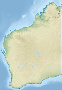
Kent Island is an uninhabited island in the Australian state of Western Australia . The island lies in the West Arm , part of the Cambridge Gulf at the mouth of the Pentecost River . The tiny island lies roughly in the middle of the arm of the water that extends deep into the land between the much larger islands of Adolphus Island and Fairfax Island , which lies between the west and east arm . The mainland in the west is around two kilometers from the Australian mainland. About one and a half kilometers to the coast is the small Saville Island .
Kent Island is 130 meters long and 70 meters wide.
Individual evidence
- ↑ Kent Island mapcarta.com (English). Last accessed on October 6, 2017
