
Kerspe dam
| Kerspe dam | |||||||
|---|---|---|---|---|---|---|---|
 |
|||||||
|
|||||||
|
|||||||
| Coordinates | 51 ° 7 '29 " N , 7 ° 29' 22" E | ||||||
| Data on the structure | |||||||
| Construction time: | 1908-1912 | ||||||
| Height above valley floor: | 28.5 m | ||||||
| Height above foundation level : | 34.57 m | ||||||
| Height above the river bed : | 32 m | ||||||
| Height of the structure crown: | 329.07 m | ||||||
| Building volume: | 70,000 m³ | ||||||
| Crown length: | 360 m | ||||||
| Crown width: | 6 m | ||||||
| Base width: | 23 m | ||||||
| Radius of curvature : | 307 m | ||||||
| Data on the reservoir | |||||||
| Altitude (at congestion destination ) | 327.78 m above sea level NN | ||||||
| Water surface | 150 ha | ||||||
| Storage space | 15.5 million m³ | ||||||
| Catchment area | 27.5 km² | ||||||
| Design flood : | 53 m³ / s | ||||||

The Kerspe dam , located in the urban area of Halver , Kierspe and Wipperfürth , serves to produce drinking water for the cities of Wuppertal , Wipperfürth and Remscheid . The gravity dam built from processed quarry stone between 1908 and 1912 dams the Kerspe . The barrier structure was designed by Otto Intze , Aachen. Until December 31, 2015, the dam operator of the facility, which was commissioned in 1913, was the Wuppertaler Stadtwerke (WSW). On January 1, 2016, the dam became the property of the Wupperverband , which had acquired it from WSW together with the Herbringhauser dam for EUR 46 million.
The reservoir for the permanent storage of drinking water, located in the area of the Oberbergisches Kreis and the Märkisches Kreis in North Rhine-Westphalia, is subordinate to the state environmental agency in Cologne. Every year 20 million m³ are withdrawn from it, the maximum daily withdrawal amount is 70,000 m³.
The catchment area of the reservoir is a water protection area according to the Water Management Act (WHG). Access to the bank is not possible for the public as it is located in water protection zone I.
The dam was renovated and reinforced in the 1990s. You got a control passage and a front cut-off wall. All operating and monitoring equipment was also renewed. A small hydropower plant with 2 × 68 kW output was also installed.
Several residential areas were flooded during the damming, including Ober- and Niederhersbach , Kerspe , Kersper Brücke , Strombach , Strombacher Hammer and several powder mills on the Kerspebach.
In the catchment area of the Kerspetalsperre was the single courtyard settlement (regional special form of the hall house ) Rhinschenschmidthausen . With the transfer to the LVR open-air museum in Kommern , it was saved from sinking in the rising water of the dam. Today the house from Rhinschenschmidthausen, built in 1724, can be viewed there in the Bergisches Land building group.

Dam wall from the air
The dam wall from a distance

Information sign with identification data

Do Not Enter!
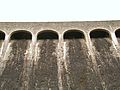
The overflow of the dam seen from below

Water drainage from the power plant into the stilling basin

Former fittings on display


See also
literature
- Kerspetalsperre - the water reservoir in the middle of the Bergisches Land ++ service provider with plus point / unfortunately without other useful, time- related information = WSW Wuppertaler Stadtwerke AG.
Web links
- Dams directory NRW (PDF; 124 kB)
- Dams in North Rhine-Westphalia; State Environment Agency NRW (PDF; 124 kB)
- Complete renovation of the Kerspetal dam / NRW
- Two turbines and generators installed
- PDF at www.maerkischer-kreis.de
- PDF at www.bezreg-koeln.nrw.de
Individual evidence
- ^ LVR open-air museum in Kommern. Rheinisches Landesmuseum für Volkskunde. Museum guide, arr. v. Michael H. Faber. Editorial assistance: Yvonne Breuer u. Andrea Nowotny. Based on the previous museum guide by Joachim Hähnel, arr. v. Michael Faber and Manuela Schütze, Cologne 2000. With contributions from Claus Cepok, Ingo Esser u. Carsten Vorwig. Mechernich-Kommern 2009 (= guides and writings of the LVR-Freilichtmuseum Kommern - Rheinisches Landesmuseum für Volkskunde No. 62) ISBN 978-3-00-025698-1 , p. 224.