Kesselfall (Semriach)
| Kesselfall | ||
|---|---|---|
| Coordinates | 47 ° 12 '20 " N , 15 ° 23' 56" E | |
|
|
||
| place | Semriach municipality , Graz-Umgebung district , Styria , Austria | |
| Falling watercourse | Rötschbach | |
| Estuarine waters | Rötschbach → Mur | |
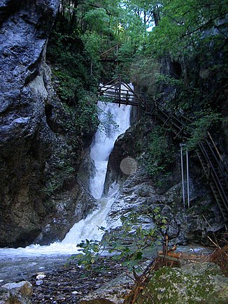
The Kesselfall is a waterfall in the municipality of Semriach in Styria . It is part of the Kesselfallklamm, which is named after him and accessible and is fed by the Rötschbach.
history
As early as 1873, a footpath in the so-called Rötschgraben to the Kesselfall was started. The waterfall, which falls in several steps at a height of 38 meters, got its name from the kettles (basins). The access to the waterfall was made possible by two wooden stairs. Ernst von Coelin and the Styrian Mountain Association began in 1904 to make the entire Kesselfallklamm accessible. The path stretched over 600 meters from the “Alten Sandwirt” to the “Kerschbaummühle”. The facility opened on July 31, 1904. A marble plaque by the waterfall commemorates the event.
In the course of its history, the climbing system in the gorge was damaged by floods. A severe storm devastated the Kesselfallklamm in July 1975 and tore away large parts of the facility. A short time later it was rebuilt. The Kesselfallklamm is currently operated by the Austrian Alpine Association.
Since 2003, the Grazer Umland-Weg , supervised by Naturefriends , has been leading through the gorge.
Web links
- Rudolf Speil: Gorges and gorges in Austria . On roaring waters. Leopold Stocker, 2008, ISBN 978-3-7020-1130-7 , pp. 262-264 ( austria-forum.org ).
Individual evidence
- ↑ a b Chronicle of the Kesselfallklamm ( Memento of the original from March 25, 2010 in the Internet Archive ) Info: The archive link was automatically inserted and not yet checked. Please check the original and archive link according to the instructions and then remove this notice.

