
Semriach
|
market community Semriach
|
||
|---|---|---|
| coat of arms | Austria map | |
 |
|
|
| Basic data | ||
| Country: | Austria | |
| State : | Styria | |
| Political District : | Graz area | |
| License plate : | GU | |
| Surface: | 60.34 km² | |
| Coordinates : | 47 ° 13 ' N , 15 ° 24' E | |
| Height : | 709 m above sea level A. | |
| Residents : | 3,291 (January 1, 2020) | |
| Population density : | 55 inhabitants per km² | |
| Postal code : | 8102 | |
| Area code : | 03127 | |
| Community code : | 6 06 45 | |
| NUTS region | AT221 | |
| Address of the municipal administration: |
Markt 27 8102 Semriach |
|
| Website: | ||
| politics | ||
| Mayor : | Gottfried Rieger ( ÖVP ) | |
|
Municipal Council : (2020) (21 members) |
||
| Location of Semriach in the Graz-Umgebung district | ||
  |
||
 View from the Kogel to Semriach |
||
| Source: Municipal data from Statistics Austria | ||

Semriach is a market town with 3291 inhabitants (as of January 1, 2020) on the north side of the Schöckl in the Graz-Umgebung district in Styria .
geography
Geographical location
Semriach is located about 25 km north of the provincial capital Graz on a high plateau, the Semriach Basin in the Grazer Bergland in Eastern Styria . With Schöckl (1445 m), Niederschöckl (1340 m), Hochtrötsch (1239 m), Fragnerberg (1109 m), Windhofkogel (1064 m), Rinnweberkogel (1041 m) and Rechbergkogel (1021 m), there are seven mountains over 1000 m in the municipality m height.
Expansion of the municipal area
Semriach is one of the largest communities in the Graz-Umgebung district. It stretches from Rechberg in the north to Schöckl in the south over 9 km and from Tanneben in the west to the district border with the Weiz district in the east over 7 km.
Community structure
The municipality includes the following seven localities (population in brackets as of January 1, 2020):
- Markterviertl (198) including Bach, Hub, Kogel, Mitteregg and Taschen
- Präbichl (147) including Augraben and Hitzendorf
- Rechberg (276) including Graben, Kampegg, Karner, Rechbergdorf, Schitterdorf and Waxenegg
- Schönegg (486) including Anger, Boden, Dreihöfen, Greith, Hollegg, Kogel, Mitterdorf am Trötsch, Pöllau, and Trötsch
- Semriach (1366) including Bach, Haaranger, Hitzendorf, Lur, Meierhöfen, Neudorf and Reitzengraben
- Thoneben (363) including Hiening, Jostensiedlung, Rötschgraben and Schachen
- Windhof (455) including Glett, Hochstraße, Oberrötschbach, Oberwindhof, Schöckl, Ulrichsbrunn and Unterwindhof
The community consists of the cadastral communities Markterviertl, Rechberg, Schönegg, Semriach and Windhof.
Neighboring communities
| Frohnleiten | Frohnleiten | Fladnitz at the Teichalm |
| Peggau | Passail | |
| Burr grain | Stattegg | Sankt Radegund near Graz |
history

Stone axes and pot shards from the Badl and Repolust caves are the oldest evidence of human settlement in Styria and were dated to the Younger Stone Age and Hallstatt Age.
The Roman times also left evidence in greater numbers. The Roman barrow on the Krienzer-Kogl, discovered in 1962, deserves special mention, but there are also Roman inscription stones on the south wall of the parish church.
Only a few Slavic names bear testimony to the subsequent migration period .
Around 1050 a Romanesque predecessor was built on the site of today's parish church. From 1505 to 1543 this church was replaced by a late Gothic hall church with a length of 44.2 meters.
The first documented mention of the market comes from the year 1320. The establishment of the market can be traced back to the medieval silver mining, in which lead containing silver was extracted. After the decline of mining, the place sank into a purely agricultural community. He was only affected by long-distance trade when the Mur valley was impassable.
Population development
| year | 1869 | 1880 | 1890 | 1900 | 1910 | 1923 | 1934 | 1939 | 1951 | 1961 | 1971 | 1981 | 1991 | 2001 |
|---|---|---|---|---|---|---|---|---|---|---|---|---|---|---|
| Residents | 2,822 | 2,961 | 3,018 | 3,022 | 2,993 | 2,924 | 3,069 | 2,867 | 2,873 | 2,615 | 2,680 | 2,676 | 2,876 | 3.163 |
Culture and sights
Museums
- The art gallery K2 was built by the Semriach artist Christian Eisenberger . There are exhibitions here at regular intervals.
- A fire brigade museum has been set up in the new fire station, which has been showing numerous equipment from the Semriach volunteer fire brigade since 1891.


Buildings
- The Semriach parish church was built between 1505 and 1515. It is located in the same place as the previous Romanesque building, built around 1100 and demolished at the end of the 15th century. The church is laid out in baroque style and was last renovated in 1987. The baroque altar had to be replaced by a neo-Gothic high altar in 1896
- On the Krienzerkogel you can visit a Roman-era barrow that was exposed in 1962. It is the only surviving Roman grave in Austria.
- On the so-called local mountain southwest of the Kesselfallklamm are the sparse remains of the Luginsland Castle , also known as the Luegg ruins. In the Middle Ages, the castle was owned by the Counts of Pfannberg .
Natural monuments
- Lurgrotte , Austria's largest stalactite cave with the largest free-hanging stalactite in the world.
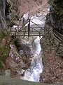
- Kesselfall Gorge : Bridges, ladders and footbridges lead through the gorge to the numerous waterfalls. Next to the gorge there is a breakthrough that is called the Stone Gate because of its shape .
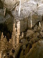
Lurgrotto

Kettle fall from below
Waterfall from above


Sports
The area around Semriach offers numerous sports opportunities in nature: hiking , Nordic walking , horse riding , archery in the great outdoors.
Economy and Infrastructure
traffic
Semriach is off the main roads, but traffic through Semriach as an alternative route to the Rechberg Pass has increased. The Pyhrn Autobahn (A9) is approx. 10 km away and can be reached via the Deutschfeistritz - Peggau junction (165). The Rechberg Straße (B 64) from Frohnleiten to Weiz runs through the northern municipality and is approx. 7 km away from the community center.
There is no train station in Semriach. The closest train station is Stübing an der Südbahn ; it offers hourly regional train connections to Graz and Bruck an der Mur . The 140 bus runs six times a day (three times on Sundays and public holidays) from Graz via Gratkorn to Semriach.
The Graz Airport is about 40 km away.
Public facilities
A mountain rescue service is located in Semriach .
politics
mayor
Mayor is Gottfried Rieger (ÖVP).
Municipal council
The municipal council consists of 21 members and has been composed of mandates from the following parties since the 2015 municipal council election:
The last municipal council elections brought the following results:
| Political party | 2015 | 2010 | ||||
|---|---|---|---|---|---|---|
| Sti. | % | M. | Sti. | % | M. | |
| ÖVP | 1222 | 61 | 13 | 1229 | 58 | 13 |
| SPÖ | 308 | 15th | 3 | 512 | 24 | 5 |
| FPÖ | 475 | 24 | 5 | 278 | 13 | 3 |
| BZÖ | not running | 90 | 4th | 0 | ||
| voter turnout | 76% | 81% | ||||
coat of arms
The coat of arms of Semriach shows a shield split in two halves. In the left half of the shield, a stag, turned to the right and hit on the chest by a silver-colored arrow, rises on a red background from the central dome of a green trefoil. The right half of the shield shows, on a blue background, a round tower with a half-raised golden portcullis and a red, golden pompous roof, built on a green mountain of silver-colored cuboids, above three windows placed side by side, below by a gate with a half-raised golden portcullis.
The wounded stag in the left field refers to the legend of St. Aegidius, the church patron of Semriach. The silver defense tower stands for the former castles of Luginsland and Forchtenberg as well as for the former silver mining in Semriach.
Personalities
Honorary citizen
- 1972: Emmy Hiesleitner-Singer (1884–1980), graphic artist and painter
- 1975: Franz Wegart (1918–2009), Styrian state politician, including state governor deputy and state parliament president
- 2015: Jakob Taibinger (* 1945), mayor from 1990–2015
Sons and daughters of the church
- Christian Eisenberger (* 1978), artist, lives and works in Vienna
- Marlena Martinelli (* 1979), pop singer from Semriach
- Hans Rinner (1963–2018), entrepreneur and ex-president of Sturm Graz
- Josef Trattner (* 1955), artist and member of the Vienna Secession ; lives and works in Vienna
- Martin Wabl (* 1945), politician and lawyer
People in connection with Semriach
- Aramis (1950–2010), actually Hans Peter Sagmüller, artist and author; lived in Semriach
- Hans Gsellmann (* 1929; † July 4, 2011), Styrian legend of mountaineering, skiing and photography; lived in Semriach
- Johann Karlon , artist and member of the Carlone family of artists ; lived in Semriach
- Franz Parz , instrument maker of the Styrian harmonica ; lives in Semriach
- Martina Schenk (* 1972), from 2008 to 2013 member of the Austrian National Council for the BZÖ, moved to Team Stronach in 2013, and since 2017 FLÖ
Web links
- 60645 - Semriach. Community data, Statistics Austria .
- Semriach
- Lurgrotte Semriach
- Luginsland / Luegg
- In the Ochsenhimmelreich , documentation of a cattle auction from 1994 in the online archive of the Austrian Media Library
Individual evidence
- ↑ Statistics Austria: Population on January 1st, 2020 by locality (area status on January 1st, 2020) , ( CSV )
- ^ Community homepage
- ^ Christian Eisenberger: Art with cocoons & clubs . Kleine Zeitung , June 4, 2008, archived from the original on September 14, 2014 .
- ↑ Christoph Marek: Pop / Schlager. An analysis of the development processes of popular music in the US and German-speaking countries , Lit Verlag, Vienna 2006, ISBN 3-8258-9456-8 , p. 68.
- ↑ "Kleine Zeitung" of July 8, 2011, p. 75.

Deutschfeistritz |
Dobl-Zwaring |
Eggersdorf near Graz |
Feldkirchen near Graz |
Fernitz-Mellach |
Frohnleiten |
Gössendorf |
Burr grain |
Gratwein street angel |
Hart near Graz |
Haselsdorf-Tobelbad |
Hausmannstätten |
Hitzendorf |
Kainbach near Graz |
Kalsdorf near Graz |
Kumberg |
Laßnitzhöhe |
Lieboch |
Nestelbach near Graz |
Peggau |
Premstätten |
Raaba-Grambach |
Saint Bartholomew |
Sankt Marein near Graz |
Sankt Oswald bei Plankenwarth |
Sankt Radegund near Graz |
Seiersberg-Pirka |
Semriach |
Stattegg |
Stiwoll |
Thal |
Ubelbach |
Vasoldsberg |
Weinitzen |
Werndorf |
Wundschuh
15 former communities (dissolved 1945–1992): Affenberg |
Edelsbach near Graz |
Gnaning |
Hart bei Eggersdorf |
Haselbach-Buchegg |
Hof |
Mauritzen |
Mitterlaßnitz |
Petzendorf |
Pöls on the Wieserbahn |
Reitergg |
Rothleiten |
Ubelbach Land |
Ubelbach Market |
Windhof 26 former municipalities (dissolved in 2015): Attendorf |
Brodingberg |
Dobl |
Edelsgrub |
Eisbach |
Fernitz |
Grambach |
Gratwein |
Großstübing |
Gschnaidt |
Hart-Purgstall |
Höf-Präbach |
Judendorf street angel |
Krumegg |
Langegg near Graz |
Mellach |
Petersdorf II |
Pirka |
Raaba |
Rohrbach-Steinberg |
Röthelstein |
Schrems near Frohnleiten |
Seiersberg |
Unterpremstätten |
Zettling |
Zwaring-Pöls