Dobl
| Dobl (former municipality) | ||
|---|---|---|
|
|
||
| Basic data | ||
| Pole. District , state | Graz-Umgebung (GU), Styria | |
| Judicial district | Graz-East | |
| Coordinates | 46 ° 56 '48 " N , 15 ° 22' 35" E | |
| height | 349 m above sea level A. | |
| Residents of the stat. An H. | 1887 (January 1, 2016) | |
| Building status | 594 (2011 ) | |
| surface | 13.66 km² | |
| Post Code | 8143 Dobl | |
| prefix | + 43/3136 (Dobl) | |
| Statistical identification | ||
| Community code | 60660 | |
| Counting district / district | Dobl (60 660 000) | |

|
||
| Independent municipality until the end of 2014; KG: 63209 Dobl, 63258 Muttendorf, 63296 Petzendorf; OS: 14901 Dobl, 14902 Muttendorf, 14903 Petzendorf, 14904 Weinzettl Source: STAT : Local directory ; BEV : GEONAM ; GIS-Stmk |
||
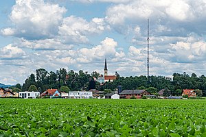
Dobl is a former market town with 1,887 inhabitants (as of January 1, 2016) southwest of Graz in the Graz-Umgebung district in the state of Styria . Since January 1, 2015, it has been merged with the municipality of Zwaring-Pöls as part of the municipal structural reform . The new municipality bears the name " Dobl-Zwaring ".
geography
Geographical location
Dobl is located in the Kaiserwald in the Kainach Valley, about 14 km southwest of Graz. The stream of the same name flows directly through the village .
Former parish structure
The municipality comprised the following four localities (residents as of January 1, 2020):
- Dobl (843)
- Muttendorf (651)
- Petzendorf (89)
- Weinzettl (401)
The community consisted of three cadastral communities (area as of 2015):
- Dobl (585.02 ha)
- Muttendorf (512.14 ha)
- Petzendorf (268.45 ha)
Former neighboring communities
| Dear | Haselsdorf-Tobelbad | Unterpremstätten |
| Lannach |

|
Unterpremstätten |
| Sankt Josef (West Styria) | Zwaring-Pöls | Zwaring-Pöls |
history
Dobl was first mentioned in documents as "Tobel" in 1219 when Archbishop Eberhard II of Salzburg assigned the district to the newly founded diocese of Seckau . For centuries the history of Dobl was influenced by Gjaidhof Castle , which was Maria Theresa's hunting lodge . On January 1, 2015, the municipality of Dobl was merged with Zwaring-Pöls to form the new market municipality of Dobl-Zwaring .
Economy and Infrastructure
traffic
The area is located on the south autobahn A 2, the closest junctions are Lieboch (194) 3 km away and Unterpremstätten (188) 5 km away. The Pyhrn Autobahn A 9 can be reached via the Schachenwald junction (192) in 5 km. The Kaiserwald service station is located on the A 2.
Bus routes from Graz to western Styria serve the Tobelbad rehabilitation center run by the General Accident Insurance Fund . The area of this hospital belonged to Dobl only until 1850. Since then it has not been in the municipality of Dobl, but in the neighboring municipality of Haselsdorf-Tobelbad to the north .
There is no train station in the area, but the neighboring communities offer access to the Graz-Köflacher Railway : In Unterpremstätten and Lieboch to the Graz- Köflach line and in Lieboch and Lannach to the (Graz) -Lieboch- Deutschlandsberg -Wies-Eibiswald line.
The Graz Airport is about 10 km away.
Culture and sights
One of the sights worth mentioning is the Dobl transmitter , a medium-wave transmitter from the Second World War . The transmitter mast, like the transmitter building in which the private radio station Antenne Steiermark was based, is a listed building.
Historical maps
- The Dobl area in the regional surveys from 1790 to 1910
The area north of Dobl with Dobelbad and Dobelzipf in the Josephinische Landesaufnahme around 1790
Dobl north of the Kainachtal, recording sheet of the Franzisco-Josephinische Landesaufnahme around 1878
The Dobl area (top left) in the Franzisco-Josephinische Landesaufnahme around 1910
Web links
Individual evidence
- ^ Announcement of the Styrian regional government of December 19, 2013 on the unification of the market community Dobl and the community Zwaring-Pöls, both political district Graz-Umgebung. Styrian Provincial Law Gazette of December 30, 2013. No. 188, 38th issue. ZDB ID 705127-x . P. 764.
- ↑ Statistics Austria: Population on January 1st, 2020 by locality (area status on January 1st, 2020) , ( CSV )
- ↑ cadastral communities Styria. 2015 (Excel file, 128 kB); Retrieved July 29, 2015


