Neudorf near Passail
|
Neudorf bei Passail (Former municipality) Cadastral municipality Neudorf near Semriach |
||
|---|---|---|
|
|
||
| Basic data | ||
| Pole. District , state | Weiz (WZ), Styria | |
| Judicial district | Wheat | |
| Coordinates | 47 ° 15 ′ 18 ″ N , 15 ° 28 ′ 1 ″ E | |
| height | 800 m above sea level A. | |
| Residents of the stat. An H. | 492 (January 1, 2015) | |
| Building status | 200 (2001 ) | |
| Area d. KG | 1271.17 ha (2019) | |
| Postcodes | 8102, 8162 | |
| prefix | + 43/3179 (Passail) | |
| Statistical identification | ||
| Community code | 61763 | |
| Cadastral parish number | 68240 | |
| Counting district / district | Neudorf near Passail (61763 005) | |
 Location of the former municipality in the Weiz district |
||
| Independent municipality until the end of 2014; Locations: 16315 Amstein, 16316 Oberneudorf, 16317 Untersteudorf Source: STAT : Local directory ; BEV : GEONAM ; GIS-Stmk |
||
Neudorf bei Passail is a former municipality with 492 inhabitants (as of January 1, 2015) in Eastern Styria. The former municipality is now Neudorf bei Semriach and is a cadastral municipality of the municipality of Passail , because as part of the municipal structural reform in Styria , the municipality was incorporated into the municipality of Passail in 2015 together with the previously independent municipalities of Hohenau an der Raab and Arzberg . The basis for this was the Styrian Municipal Structural Reform Act - StGsrG.
geography
Neudorf bei Passail is located southwest of Passail in the judicial district or district of Weiz .
structure
The municipality is divided into three localities (residents as of January 1, 2020):
- Amstein (80)
- Oberneudorf (232)
- Untereudorf (155)
The former municipality is congruent with the still existing cadastral municipality of Neudorf bei Semriach .
politics
The last mayor was Johann Schrei (FPÖ). After the municipal council elections in 2010, the local council was composed as follows:
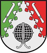
coat of arms
Description:
- The globe stands for the historic surveying stone on the Schöckl (in what was then Neudorf's municipality), which was used for the first meridian measurement between Brno and Varaždin in the second half of the 18th century under Maria Theresa .
- On the one hand, the clearing knives symbolize the Count Dietrichstein as the owners of the Semriach and Rabenstein lords in the 18th and 19th centuries. Century (largest landlords in the municipality), on the other hand the clearing activity in the Schöckl area, from which the Neudorf settlement emerged in the High Middle Ages.
- The linden leaf cut documents the former frequent presence of the linden tree and the healing properties of its flowers.
- Silver is the earthly, earthly metal and was also mined on a property in Neudorf, green the color of fresh vegetation and nature, the symbol of hope and is the complementary color to red, the symbol of strength and youthful freshness, of human life at all.
Web links
Individual evidence
- ^ Styrian municipal structural reform .
- ↑ Section 3, Paragraph 11, Item 2 of the Act of December 17, 2013 on the reorganization of the municipalities of the State of Styria ( Styrian Municipal Reform Act - StGsrG). Provincial Law Gazette for Styria of April 2, 2014, No. 31, year 2014, ZDB -ID 705127-x , p. 4.
- ↑ Statistics Austria: Population on January 1st, 2020 by locality (area status on January 1st, 2020) , ( CSV )


