
Raaba-Grambach
|
market community Raaba-Grambach
|
||
|---|---|---|
| coat of arms | Austria map | |
 |
|
|
| Basic data | ||
| Country: | Austria | |
| State : | Styria | |
| Political District : | Graz area | |
| License plate : | GU | |
| Main town : | Raaba | |
| Surface: | 14.64 km² | |
| Coordinates : | 47 ° 2 ' N , 15 ° 30' E | |
| Height : | 350 m above sea level A. | |
| Residents : | 4,676 (Jan 1, 2020) | |
| Postcodes : | 8071, 8074, 8302 | |
| Area code : | 0316 | |
| Community code : | 6 06 67 | |
| NUTS region | AT221 | |
| Address of the municipal administration: |
Josef-Krainer-Strasse 40 8074 Raaba-Grambach |
|
| Website: | ||
| politics | ||
| Mayor : | Karl Mayrhold ( SPÖ ) | |
|
Municipal Council : (Election year: 2020) (21 members) |
||
| Location of Raaba-Grambach in the Graz-Umgebung district | ||
  |
||
| Source: Municipal data from Statistics Austria | ||

Raaba-Grambach has been a market town in the Graz-Umgebung district in Styria since the beginning of 2015 . It emerged as part of the municipal structural reform in Styria from the municipalities of Raaba and Grambach, which were dissolved at the end of 2014 . A complaint lodged by both municipalities against the merger with the Constitutional Court was unsuccessful.
geography
Geographical location
The community is located on the south-eastern outskirts of the provincial capital Graz in the eastern Styrian hill country and belongs to the Graz Basin . The main flowing water is the Raababach , on which a flood retention basin was built by 2017 .
Community structure
The municipality comprises four localities (residents as of January 1, 2020):
- Dürwagersbach (181) including Sternleiten
- Grambach (1912) including Eisenberg, Erlenstraße, Forstsiedlung, Grünfeldsiedlung, Himmelreich, Hinterleiten, Höhenstraße and Wolfsgraben
- Lamberg (251)
- Raaba (2332) including Hart and Tiefental
and consists of two cadastral communities (area as of 2015):
Incorporations
On January 1st, 2015 the communities Raaba and Grambach were merged.
Neighboring communities
| Graz | Hard near Graz | Laßnitzhöhe |
| Gössendorf |
.svg)
|
Vasoldsberg |
| Gössendorf | Hausmannstätten | Vasoldsberg |
history
In 1265 Grambach was first mentioned in the registers of the Graz Marshal's Office.
Until 1848 the place belonged to several manors like the dominions Liebenau, Messendorf-Hintenfeld, Münzgraben, Mühlegg, Schwarzenegg, Vasoldsberg, the upcoming Leech of the Kreuzerischen gilt, the Dominican Sisters of Graz, the Gut Kellerhof and the parish houses Hausmannstätten and Fernitz.
The two local parishes of Raaba and Grambach came into being in 1850 as autonomous bodies. After the annexation of Austria in 1938, the municipalities became part of the Reichsgau Steiermark, from 1945 to 1955 they were part of the British zone of occupation in Austria.
In 2000 Raaba was raised to a market town.
Culture and sights


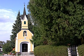
Lady Chapel in Raaba

Local chapel in Grambach

Chapel of the Scourged Savior in Raaba


- Player yard in Grambach
- Böhmervilla in Raaba, was built in the Art Nouveau style as Gut Neuhof in 1870 and renovated in 1910.
- Lady Chapel in Raaba
- Local chapel in Grambach
- Chapel of the Scourged Savior in Raaba
Parks
The Life Park in 2000 in Raaba created by the merger of the Bohemian parks with the garden spot of the grounds and has an area of about 11,000 sqm.
Economy and Infrastructure
traffic
Due to its proximity to Graz, Raaba-Grambach is very conveniently located. The south autobahn A2 runs directly through the area and can be reached from all parts of the village via the Puchwerk junction on the Graz-Ost autobahn slip road . The Unterkirchbacherstraße B 73 can in the neighboring Hausmannstätten be reached after about two kilometers.
In Raaba there is a Styrian Eastern Railway station , which offers hourly regional train connections to Graz and Gleisdorf . The central station Graz is about eight kilometers away. Raaba-Grambach is connected to the bus network of Graz AG Verkehrsbetriebe .
The distance to Graz Airport is around seven to ten kilometers.

Established businesses
In Raaba-Grambach u. a. the following companies locations:
- the data center and other departments of Raiffeisen-Landesbank Steiermark
- the Raiffeisenverband Steiermark
- the Alpine processing industry (AVI)
- the development and utilization GmbH (EVG)
- the Hutter and Schranz fence technology (H + S)
- the Andritz Energy & Environment
- the NTS Netzwerk Telekom Service AG
- the Spari Stahlbau GmbH
The waste water of the municipality are in the water treatment plant of the city of Graz in Gössendorf cleaned and then the Mur fed.
politics
Municipal council
The 21 seats in the municipal council are distributed as follows after the 2015 municipal council elections:
coat of arms
- Coats of arms of the previous municipalities

Raaba

Grambach


Both previous municipalities had a municipality coat of arms. Due to the amalgamation of municipalities, these lost their official validity on January 1st, 2015. The new municipal coat of arms for the merged community took place on October 20, 2016.
Blazon (coat of arms description):
- “In the black and gold bordered red shield there is a golden, black bordered diagonal right bar, covered with four black six-spoke wagon wheels adjoining on all sides; from the edge of the shield and the bar growing upwards, three golden spikes. "
literature
- Mag. Ingo Mirsch, Dr. Carol Veenstra: The story of a community ( story of Raaba ). Available at the municipal office.
- Mag. Ingo Mirsch: Raaba 1849 - 2000 . Published on the occasion of the market survey. Available at the municipal office.
Web links
- 60667 - Raaba-Grambach. Community data, Statistics Austria .
- www.raaba-grambach.gv.at
Individual evidence
- ^ Styrian municipal structural reform .
- ↑ § 3 Paragraph 3 Z 4 StGsrG, Provincial Law Gazette for Styria No. 31, year 2014. ZDB -ID 705127-x .
- ↑ recognition of the Constitutional Court of 23 September 2014 G 47/2014, G 114/2014.
- ↑ Statistics Austria: Population on January 1st, 2020 by locality (area status on January 1st, 2020) , ( CSV )
- ↑ cadastral communities Styria. 2015 (Excel file, 128 kB); Retrieved July 29, 2015
- ↑ [Statistics Austria: dissolutions or associations of municipalities from 1945 http://www.statistik.at/web_de/static/gemeindeaenderungen_ab_1945_vereinigungen_teilungen_namens-_u._statusaende_054994.pdf ]
- ↑ Holding Graz quoted in: Josef Riegler: Chronik der Marktgemeinde Gössendorf . 2nd, updated and expanded edition, Marktgemeinde Gössendorf 2017, pp. 163–165.
- ↑ 122. Announcement of the Styrian state government of October 6, 2016 on the granting of the right to use a municipal coat of arms to the market town of Raaba-Grambach (political district of Graz-Umgebung) , accessed on October 20, 2016
Cadastral communities: Grambach | Raaba
Locations: Dürwagersbach | Grambach | Raaba
Market place: Raaba Village: Grambach Settlements: Forstsiedlung • Grünfeldsiedlung Rotten: Eisenberg • Erlenstrasse • Hart • Himmelreich • Hinterleiten • Höhenstrasse • Lamberg • Sternleiten • Tiefental • Wolfsgraben Scattered houses: Dürwagersbach
Counting district: Grambach | Raaba

Deutschfeistritz |
Dobl-Zwaring |
Eggersdorf near Graz |
Feldkirchen near Graz |
Fernitz-Mellach |
Frohnleiten |
Gössendorf |
Burr grain |
Gratwein street angel |
Hart near Graz |
Haselsdorf-Tobelbad |
Hausmannstätten |
Hitzendorf |
Kainbach near Graz |
Kalsdorf near Graz |
Kumberg |
Laßnitzhöhe |
Lieboch |
Nestelbach near Graz |
Peggau |
Premstätten |
Raaba-Grambach |
Saint Bartholomew |
Sankt Marein near Graz |
Sankt Oswald bei Plankenwarth |
Sankt Radegund near Graz |
Seiersberg-Pirka |
Semriach |
Stattegg |
Stiwoll |
Thal |
Ubelbach |
Vasoldsberg |
Weinitzen |
Werndorf |
Wundschuh
15 former communities (dissolved 1945–1992): Affenberg |
Edelsbach near Graz |
Gnaning |
Hart bei Eggersdorf |
Haselbach-Buchegg |
Hof |
Mauritzen |
Mitterlaßnitz |
Petzendorf |
Pöls on the Wieserbahn |
Reitergg |
Rothleiten |
Ubelbach Land |
Ubelbach Market |
Windhof 26 former municipalities (dissolved in 2015): Attendorf |
Brodingberg |
Dobl |
Edelsgrub |
Eisbach |
Fernitz |
Grambach |
Gratwein |
Großstübing |
Gschnaidt |
Hart-Purgstall |
Höf-Präbach |
Judendorf street angel |
Krumegg |
Langegg near Graz |
Mellach |
Petersdorf II |
Pirka |
Raaba |
Rohrbach-Steinberg |
Röthelstein |
Schrems near Frohnleiten |
Seiersberg |
Unterpremstätten |
Zettling |
Zwaring-Pöls