
Raababach
| Raababach | ||
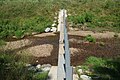
 Renatured stream in the retention basin |
||
| Data | ||
| location | Styria , Austria | |
| River system | Danube | |
| Drain over | Mur → Drava → Danube → Black Sea | |
| source | southeast of Hönigtal 47 ° 5 ′ 27 ″ N , 15 ° 34 ′ 10 ″ E |
|
| Source height | 500 m above sea level A. | |
| muzzle | at Gössendorf in the Mur coordinates: 46 ° 59 '28 " N , 15 ° 28' 25" O 46 ° 59 '28 " N , 15 ° 28' 25" O |
|
| Mouth height | 321 m above sea level A. | |
| Height difference | 179 m | |
| Bottom slope | 10 ‰ | |
| length | 17.2 km | |
| Catchment area | 35.89 km² | |
| Left tributaries | Moggaubach, Wöblingbach, Grambach | |
| Right tributaries | Wagnerbach, Brühlwaldbach, Reintalbach, Messendorferbach, (Gössendorfer Mühlkanal) | |
| Communities | Kainbach near Graz , Laßnitzhöhe , Hart near Graz , Raaba-Grambach , Gössendorf | |
| Residents in the catchment area | approx. 10,000 (2017) | |
The Raababach is a left bank tributary of the Mur in the Austrian state of Styria . It forms a sole valley east of the provincial capital Graz and flows into the Mur after 17 km at Gössendorf .
course

According to the Digital Atlas of the State of Styria, the Raababach, known in the upper reaches as the Kohlgrabenbach, rises southeast of Hönigtal . The land register of the BMLFUW names a confluence of the source streams Kohlgrabenbach (right) and Moggaubach (left) as the place of origin. The stream initially flows parallel to the Ostbahn through the Tomschetal and then runs largely close to nature along the south A 2 motorway . After the village of Autal, the now straightened Raababach takes on the Wöblingbach and forms the southern border of the municipality of Hart bei Graz near Pachern . After the confluence of the Reintal, the stream crosses a flood retention basin , which was completed in 2017, in a largely renatured setting, before the valley opens into the Grazer Feld in Raaba .
In the market town of Gössendorf , where the Raababach formerly converged with the Gössendorfer Mühlkanal , its water now runs through the alluvial forest directly towards the Mur. It flows into the underwater area of the Gössendorf power plant around 500 m south of the city of Graz's sewage treatment plant .
Flood protection
The Raab Abach made in the past often for floods in the municipalities Raaba Grambach and Gössendorf, most recently in 2009 and 2013. in this regard the first studies were undertaken in 1978, after a runoff study in 2008 and a project that determines in 2010 was the establishment of a Flood retention basin in the north of the Raaba-Grambach municipality . After a year and a half of construction, including recultivation measures , the retention basin, which is also intended to serve as a recreation area, was officially opened in July 2017. The system, which is designed for a 100- year flood (HQ 100 ), has a retention volume of 228,500 m³ and is surrounded by an 1150 m long and maximum 12.5 m high dam . The finance amounting to 5.84 million euros was provided to 47.5% by the ministry, the rest from the state and municipality. In addition, a motorway exit to Pachern is planned over the dam .
Between 2006 and 2009, the HQ 100 flood areas for Gössendorf downstream were determined and the endangerment of a total of 300 residential buildings as well as important infrastructure and some farms were determined. Due to a rated discharge of 43 m³ / s, a linear expansion of the stream bed, consisting of walls and dams, began in 2017. 35% of the costs of 10 million euros were financed by the federal and state governments, the remainder was borne by the municipality.
photos
Sediment lock

Retention basin with a view upstream

Retention basin from the east

Stream in the retention basin

Retention basin outlet

Stream before entering the Mur floodplains


Web links
- Flood risk management plan 2015 - Raaba-Gössendorf risk area
- Plan of the Raababach retention basin
- Flood protection in the community of Gössendorf
Individual evidence
- ↑ a b Digital Atlas of Styria: Waters & Water Information. State of Styria , accessed April 7, 2019 .
- ↑ BMLFUW (ed.) : List of areas of the Austrian river basins: Mur area. In: Contributions to Austria's Hydrography Issue No. 60, Vienna 2011, p. 90. PDF download , accessed on July 14, 2018.
- ↑ a b c Raababach flood protection. Federal Ministry for Sustainability and Tourism , November 17, 2015, accessed on November 19, 2018 .
- ↑ a b Opening of the Raababach retention basin. State of Styria , July 8, 2017, accessed November 19, 2018 .
- ↑ a b Completion of the Raababach retention basin and opening ceremony. Citizen Service of the Raaba-Grambach / Johannes Ulrich community, June 21, 2017, accessed on November 19, 2018 .
- ↑ Groundbreaking for a multi-million dollar project on Raababach. State of Styria , October 28, 2015, accessed on November 19, 2018 .
- ^ HWS Raababach in the communities of Gössendorf and Raaba-Grambach. State of Styria and others / Johannes Ulrich, February 2016, accessed on November 19, 2018 .
- ↑ Groundbreaking ceremony for Raababach flood protection. State of Styria , May 15, 2017, accessed on November 19, 2018 .