
Werndorf
|
Werndorf
|
||
|---|---|---|
| coat of arms | Austria map | |
 |
|
|
| Basic data | ||
| Country: | Austria | |
| State : | Styria | |
| Political District : | Graz area | |
| License plate : | GU | |
| Surface: | 6.24 km² | |
| Coordinates : | 46 ° 55 ' N , 15 ° 29' E | |
| Height : | 309 m above sea level A. | |
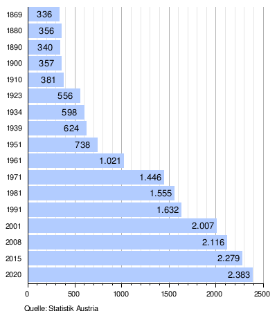
| Residents : | 2,383 (Jan 1, 2020) | |
| Postal code : | 8402 | |
| Area code : | 03135 | |
| Community code : | 6 06 55 | |
| NUTS region | AT221 | |
| Address of the municipal administration: |
Bundesstrasse 135 8402 Werndorf |
|
| Website: | ||
| politics | ||
| Mayor : | Willibald Rohrer ( SPÖ ) | |
|
Municipal Council : (2020) (15 members) |
||
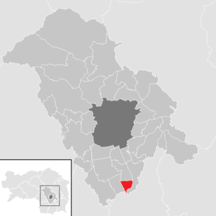
| Location of Werndorf in the Graz-Umgebung district | ||
  |
||
 The district heating power plant is the landmark of Werndorf that can be seen from afar |
||
| Source: Municipal data from Statistics Austria | ||

Werndorf is an Austrian municipality south of Graz with 2383 inhabitants (as of January 1, 2020) in Styria in the Graz-Umgebung district .
geography
Geographical location
Werndorf is about 15 kilometers south of the provincial capital Graz in the Graz Basin . The community lies on the Mur .
Community structure
There are no other cadastral communities and localities except Werndorf, the community area is 6.24 km². Districts are:
- Railway settlement, heaven, northern settlement, scythe factory, settlements and western settlement.
Neighboring communities
| Kalsdorf near Graz | ||
| Wound shoe |
.svg)
|
Fernitz-Mellach |
| Wildon |
history
In 1144, Werndorf was first mentioned in a document as a donation to Rein Abbey under the name “Zuwerendorf”. The name goes back to the Old High German personal name Wero / Waro . Until the abolition of the landlord in 1848, the Rhine Abbey was the largest landlord in the area. The local communities as autonomous corporations came into being in 1850. Werndorf came to the community of Kalsdorf as a tax community.
In 1914, due to frequent disputes, the Styrian state parliament decided to separate the village of Werndorf from the municipality of Kalsdorf, but this was only implemented on January 18, 1917. After the annexation of Austria in 1938, the community became part of the Reichsgau Steiermark, from 1945 to 1955 it was part of the British zone of occupation in Austria.
Population development
Culture and sights
Museums
- The Neumühle Bicycle Museum is located in the outbuilding of an old mill and is privately owned. It houses everything “to do with bicycles”, from high bikes and low bikes to sports bikes as exhibits and on (old) photos.
Economy and Infrastructure
traffic
The Pyhrn Autobahn A 9 touches the municipality and can be reached via the junctions Wundschuh (exit 197) and Wildon (exit 202). The Grazer Straße B 67 from Graz to Leibnitz runs directly through the municipality.
Werndorf has a freight terminal for combined transport on the southern line and its own train station. Most of the time , S-Bahn trains to Graz and Spielfeld - Straß run every hour , and at shorter intervals during rush hour . The bus connections from Graz to Leibnitz also run via Werndorf.
The Graz Airport is about eight kilometers away.
Established businesses
- The Isovolta was founded in Werndorf 1949th Today part of the production is located in the municipality.
- The Belgian company Allnex produces synthetic resins in Werndorf.
- Historical maps of the Werndorf area

“Padendorf”: Josephinische Landesaufnahme , approx. 1790

Franzisco-Josephinische Landaufnahme , ca.1910


politics
mayor
Mayor is Willibald Rohrer (SPÖ).
The community board also includes the deputy mayor Alexander Ernst (SPÖ) and the community treasurer Christian Aldrian (ÖVP).
Municipal council
The council sat down after the municipal elections of 2015 as follows:
The last municipal council elections brought the following results:
| Political party | 2020 | 2015 | 2010 | 2005 | 2000 | ||||||||||
|---|---|---|---|---|---|---|---|---|---|---|---|---|---|---|---|
| St. | % | M. | St. | % | M. | St. | % | M. | St. | % | M. | St. | % | M. | |
| SPÖ | 702 | 57 | 9 | 732 | 59 | 9 | 859 | 72 | 11 | 736 | 65 | 10 | |||
| ÖVP | 311 | 25th | 4th | 367 | 30th | 5 | 339 | 28 | 4th | 307 | 27 | 4th | |||
| FPÖ | 212 | 17th | 2 | 75 | 6th | 1 | not running | 82 | 7th | 1 | |||||
| BZÖ | not running | 65 | 5 | 0 | not running | not running | |||||||||
| voter turnout | 67% | 71% | 73% | 77% | |||||||||||
coat of arms
The municipal coat of arms was awarded with effect from October 1, 1983.
The blazon reads:
- "An octagonal silver umbrella board in green on a silver crown, with a black panther growing in it."
Honorary citizen
- 1976: Johann Bammer (1922–2017), Provincial Councilor
Web links
- 60655 - Werndorf. Community data, Statistics Austria .
- werndorf.gv.at Website of the municipality
Individual evidence
- ↑ Fritz Frhr. Lochner von Hüttenbach: On the name property of the early Middle Ages in Styria (= magazine of the Historical Association for Styria . Volume 99 ). Böhlau Verlag, Vienna 2008, p. 50 ( historerverein-stmk.at [PDF; 16.9 MB ]).
- ↑ Werndorf municipality: municipal council , accessed on July 14, 2019.
- ↑ Communications from the Styrian State Archives 34, 1984, p. 36

Deutschfeistritz |
Dobl-Zwaring |
Eggersdorf near Graz |
Feldkirchen near Graz |
Fernitz-Mellach |
Frohnleiten |
Gössendorf |
Burr grain |
Gratwein street angel |
Hart near Graz |
Haselsdorf-Tobelbad |
Hausmannstätten |
Hitzendorf |
Kainbach near Graz |
Kalsdorf near Graz |
Kumberg |
Laßnitzhöhe |
Lieboch |
Nestelbach near Graz |
Peggau |
Premstätten |
Raaba-Grambach |
Saint Bartholomew |
Sankt Marein near Graz |
Sankt Oswald bei Plankenwarth |
Sankt Radegund near Graz |
Seiersberg-Pirka |
Semriach |
Stattegg |
Stiwoll |
Thal |
Ubelbach |
Vasoldsberg |
Weinitzen |
Werndorf |
Wundschuh
15 former communities (dissolved 1945–1992): Affenberg |
Edelsbach near Graz |
Gnaning |
Hart bei Eggersdorf |
Haselbach-Buchegg |
Hof |
Mauritzen |
Mitterlaßnitz |
Petzendorf |
Pöls on the Wieserbahn |
Reitergg |
Rothleiten |
Ubelbach Land |
Ubelbach Market |
Windhof 26 former municipalities (dissolved in 2015): Attendorf |
Brodingberg |
Dobl |
Edelsgrub |
Eisbach |
Fernitz |
Grambach |
Gratwein |
Großstübing |
Gschnaidt |
Hart-Purgstall |
Höf-Präbach |
Judendorf street angel |
Krumegg |
Langegg near Graz |
Mellach |
Petersdorf II |
Pirka |
Raaba |
Rohrbach-Steinberg |
Röthelstein |
Schrems near Frohnleiten |
Seiersberg |
Unterpremstätten |
Zettling |
Zwaring-Pöls