Kete Kesu
| Kete Kesu | ||
|---|---|---|
|
|
||
| Coordinates | 3 ° 0 ′ S , 119 ° 55 ′ E | |
| Basic data | ||
| Country | Indonesia | |
|
Geographical unit |
Sulawesi | |
| province | Sulawesi Selatan | |
| ISO 3166-2 | ID-SN | |
| Kabupaten | North Toraya | |
|
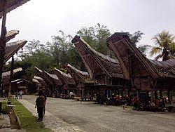
Tonkonans and rice granary (alang) in Kete Kesu
|
||
Kete Kesu or Ke'te Kesu ' is a Toraja village in Toraja Utara , Indonesia about 10 km southeast of Rantepao .
The village is one of the main tourist attractions in Toraja Utara . The village has a number of traditional houses (6 Tongkonan houses and 12 rice granaries (Alang)), with one house serving as a museum. Kete Kesu is also known for its graves in rock caves and its coffins hanging on rock walls. The graves are located about 50 meters from the village and some are estimated to be over 500 years old. Some of the traditional coffins (erong) are shaped like a boat, others like buffalo or pigs. There are also graves of nobles and more than 20 menhirs . Lemo is one of ten traditional Toraja settlements put on the "Tentative List" by the Indonesian Ministry of Culture for nominations by UNESCO .
Web links
Individual evidence
- ↑ Luwuraya.com: Pesona Kuburan Purbakala Kete Kesu. January 4, 2011. Retrieved December 1, 2012.
- ↑ http://whc.unesco.org/en/tentativelists/5462/


