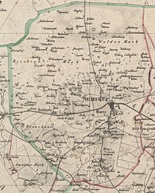
Parish of Ochtrup
Until 1890, the parish of Ochtrup was a municipality in the Steinfurt district in what was then the province of Westphalia . Today your area belongs to the city of Ochtrup in the Steinfurt district in North Rhine-Westphalia . The community was one of the "parish communities" that occurred several times in the Münsterland and comprised the rural area around a church village .
geography
The parish parish Ochtrup enclosed the Wigbold Ochtrup and had an area of 81 km². It included the Easter farmers, the West farmers and the wine farmers and the suburbs of Ochtrup Horst and Wall.
history
After the Napoleonic era , the area of the community initially belonged to the mayor's office in Ochtrup in the Steinfurt district, founded in 1816. With the introduction of the Westphalian rural community order in 1844, the mayor of Ochtrup became the Ochtrup office, to which the Wigbold Ochtrup and the parishes of the parish of Ochtrup (at the time also called the outer community of Ochtrup ), Langenhorst and Welbergen belonged. By law of April 14, 1890, Wigbold and parish Ochtrup were merged to form the municipality of Ochtrup with effect from October 1, 1890.
Population development
| year | Residents | source |
|---|---|---|
| 1832 | 3194 | |
| 1858 | 3428 | |
| 1871 | 3283 | |
| 1885 | 4355 |
Individual evidence
- ^ A b Hans-Walter Pries: Parish Ochtrup. In: HIS-Data. Retrieved January 21, 2017 .
- ↑ GenWiki: Ochtrup
- ↑ Official Journal for the Münster administrative region, 1844, page 47. Retrieved on September 3, 2017 .
- ↑ Official Journal for the Münster administrative district 1890, page 194. Retrieved on September 3, 2017 . ; Law of April 14, 1890 (GS p. 53)
- ^ Westphalia Lexicon 1832-1835 . In: Landschaftsverband Westfalen-Lippe (Ed.): Reprints for the Westphalian archive maintenance . tape 3 . Münster 1978, p. 234 (reprint of the original from 1834).
- ↑ Statistical news about the government district of Münster, 1860
- ^ Community encyclopedia for the province of Westphalia 1885
Coordinates: 52 ° 11 ' N , 7 ° 11' E
