Kisdorferwohld
|
Kisdorferwohld
community Kisdorf
Coordinates: 53 ° 49 ′ 12 ″ N , 10 ° 4 ′ 51 ″ E
|
||
|---|---|---|
| Height : | 51 m | |
| Area : | 8 km² | |
| Residents : | 350 | |
| Population density : | 44 inhabitants / km² | |
| Primaries : | 04193, 04194, 04535 | |
|
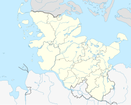
Location of Kisdorferwohld in Schleswig-Holstein |
||
Kisdorferwohld (Kisdorf Forest) is the largest and at the same time most village district of the municipality of Kisdorf in the Segeberg district in Schleswig-Holstein with an area of approx. 8 km² . Kisdorferwohld extends directly to the east of the actual village on the Rathkrügen elevation (91 m above sea level).
Kisdorferwohld is also the name for a mountain range that runs through the community of Kisdorf and the neighboring communities. It is a terminal moraine landscape from the Vistula Ice Age .
The Endern enclosure is located in Kisdorferwohld, part of the Rantzau State Forestry Office and a popular local recreation area in the region.
Furthermore, Kisdorferwohld is known nationwide as the location of the “Gut Waldhof” golf course.
history
Until the 18th century there were several in Kisdorferwohld Meiler fields where charcoal was produced. These historical fields can still be recognized today by street names.
For example:
- Willbrann - Wild fire
- Dierksbrann - Dierks Meilerfeld
During the Second World War, Kisdorferwohld was used as a strategic radio location due to its relatively high location.
