Kita-Iwojima
| Kita-Iwojima | ||
|---|---|---|
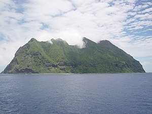
| Kita-Iwojima seen from the lake | ||
| Waters | Pacific Ocean | |
| Archipelago | Kazan-rettō | |
| Geographical location | 25 ° 26 '2 " N , 141 ° 17' 0" E | |
|
|
||
| length | 2.1 km | |
| width | 1.9 km | |
| surface | 5.56 km² | |
| Highest elevation | Sakaki-ga mine 792 m |
|
| Residents | uninhabited | |
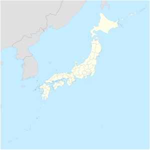
| Map of Kita-Iwojima | ||
Kita-Iwojima ( Japanese 北 硫黄島 , Kita-Iōtō , literally: "North Sulfur Island ") is a volcanic island in the Kazan-rettō ( volcanic islands ) of the Ogasawara Islands south of the main Japanese islands. Like the entire archipelago, it is administratively part of Tokyo Prefecture .
The uninhabited island is the heavily eroded summit of a stratovolcano , which protrudes 792 m (according to other information 804 m) from the sea. It covers an area of 5.56 km² and is 70 km north of Iwojima , the main island of the archipelago .
The island was inhabited earlier. When World War II broke out in 1939, the population of Kita-Iwojima was 103. This civilian population was evacuated during World War II. On the east coast was the place Ishinomura ( 石 野村 ) and on the west coast Nishimura ( 西村 ). The until then unincorporated island became part of the newly founded community Iōtō-mura in 1940 and was finally incorporated with this in 1968 to Ogasawara-mura , when the islands were returned to Japan by the United States.
On June 16, 2007, Kita-Iōjima was renamed to Kita-Iōtō, in which the Kun reading was changed back from 島 to the earlier On reading .
During the total solar eclipse on July 22, 2009 , the island was the piece of land with the longest total duration (6 minutes and 34 seconds).
Individual evidence
- ↑ 島 面積 . (PDF; 144 kB) (No longer available online.) Kokudo Chiriin , October 1, 2014, archived from the original on April 2, 2015 ; Retrieved July 28, 2016 (Japanese). Info: The archive link was inserted automatically and has not yet been checked. Please check the original and archive link according to the instructions and then remove this notice.
- ↑ NealM. Bowers: The Mariana, Volcano and Bonin Islands, in Otis W. Freeman: Geography of the Pacific, 1951, p. 229
- ↑ Map of the island from the National Land Surveyor. In: Kokudo Chiriin. Retrieved July 28, 2016 (Japanese).
- ↑ NASA: Total Solar Eclipse of 2009 July 22 - Local Circumstances for Japan and Pacific (PDF; 1.4 MB)
Web links
- Kita-Iwojima in the Global Volcanism Program of the Smithsonian Institution (English)
- Kita-Iwojima in the Japanese Volcanoes Quaternary database (English and Japanese)


